I'm wondering what geostatistical software is best for handling very large data
sets.  With the advent of GIS and remote sensing, having too much data is a
problem.  Sampling of course is useful, but only to a point if a large study
area is used.  I've read other places that among the commercial stat packages,
SAS is best at handling large data sets.  Is this true?  Also, I've produced my
own little routine in IDRISI that can create 'random' samples that are
clustered by inverse distance, so that short lags are preferred.  Are there any
software packages that can create a random sample of points that show a
pre-specified clustering pattern in space? Thanks -Seth
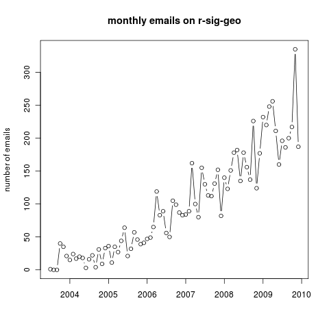
________________________________
From: owner-ai-geost...@jrc.ec.europa.eu [owner-ai-geost...@jrc.ec.europa.eu]
on behalf of Edzer Pebesma [edzer.pebe...@uni-muenster.de]
Sent: Wednesday, January 06, 2010 2:52 PM
To: Younes Fadakar
Cc: ai-geostats@jrc.it
Subject: Re: AI-GEOSTATS: (1) Geostatistics in pain

Younes, thanks for the provocative message.

I believe you are looking for this free or cheap, all-capable package with a
complete, friendly and robust graphical user interface with dynamic graphics. A
problem is that such a thing is hard and expensive to develop, and unlikely to
be arise as a side product of a research project. Look at the worlds of GIS or
image analysis -- there's a lot of high quality things out there for free, but
the thing you're looking for is very expensive.

In your list I missed at least:
9. ArcGIS + geostatistical analyst
10. SGEMS, the new Stanford software after GSLIB
11. other packages in R, such as gstat, randomFields, rsaga, and so on.
12. ... (I hope others will finish this list!)

I'm one of the many people active in the r-sig-geo community, and am constantly
astonished about the growth of the activity around R; you can see some
statistics on this in a paper in the latest issue of the R journal, e.g. fig 4
in
http://journal.r-project.org/archive/2009-2/RJournal_2009-2_Fox.pdf

The special-interest-group on spatial data with R, r-sig-geo, undergoes a
similar growth; it has now some 1400 subscribers and the development of mailing
list activity is plotted in http://ifgi.uni-muenster.de/~epebe_01/r-sig-geo.png
. A major part of this activity focuses around geostatistics.

Looking at these graphs, I have the impression that I'm not alone when thinking
that although graphical, interactive exploratory data analysis is a very nice
thing to have, a solid data analysis should start from the principle of
reproducability, and therefore as little as possible depend on the reproduction
of long sequences of mouse clicks.

Are users of this list aware of other communities and/or mailing lists where
considerable activity around geostatistics and/or geostatistical software takes
place?

Younes, could you be more precise about exactly which "serious request [...]
remained more than 20 years"?

I hope your email gets many responses,
--
Edzer

Younes Fadakar wrote:

Hi there,

This is my first message as a test message checking the usage of the service,
working with ai-geostats mailing list. I have many questions to ask you too.
To start:
The world of Geostatistics seriously needs a tool to present well to novices
and professionals. Current availabilities have many of disadvantages. Some are
too old, others not user-friendly and the rest more expensive.
1- GsLib seems powerful but too old (DOS-command line in 2010!)
2- WinGsLib is completely confusing despite of logging and automating! no
direct input and output!!
3- Variowin is too weak in terms of GUI!
4- mGstat as a Matlab toolbox written too complex not handy program!
5- GeoR as an extention for R makes you to work with R such a command-line
environment! what a development rather than GsLib!!
6- Isatis is more expensive; for what?!
7- Gs+ is in pain with weak performance of GUI!
8- Geoeas is something funny just to remember DOS graphics!
9- ...
So obviously a serious request remained for more than 20 years without suitable
answer!
Why?


Younes


__________________________________________________________________________________
See what's on at the movies in your area. Find out now:
http://au.movies.yahoo.com/session-times/

+
+ To post a message to the list, send it to
ai-geost...@jrc.ec.europa.eu<mailto:ai-geost...@jrc.ec.europa.eu>
+ To unsubscribe, send email to majordomo@ jrc.ec.europa.eu with no subject and
"unsubscribe ai-geostats" in the message body. DO NOT SEND
Subscribe/Unsubscribe requests to the list
+ As a general service to list users, please remember to post a summary of any
useful responses to your questions.
+ Support to the forum can be found at http://www.ai-geostats.org/


--
Edzer Pebesma
Institute for Geoinformatics (ifgi), University of Münster
Weseler Straße 253, 48151 Münster, Germany. Phone: +49 251
8333081, Fax: +49 251 8339763  http://ifgi.uni-muenster.de
http://www.52north.org/geostatistics
e.pebe...@wwu.de<mailto:e.pebe...@wwu.de>