    Date: Saturday, September 3, 2022 @ 19:16:06
  Author: arojas
Revision: 1292704
archrelease: copy trunk to community-any
Added:
gpsprune/repos/community-any/PKGBUILD
(from rev 1292703, gpsprune/trunk/PKGBUILD)
gpsprune/repos/community-any/gpsprune.appdata.xml
(from rev 1292703, gpsprune/trunk/gpsprune.appdata.xml)
gpsprune/repos/community-any/gpsprune.desktop
(from rev 1292703, gpsprune/trunk/gpsprune.desktop)
gpsprune/repos/community-any/gpsprune.sh
(from rev 1292703, gpsprune/trunk/gpsprune.sh)
Deleted:
gpsprune/repos/community-any/PKGBUILD
gpsprune/repos/community-any/gpsprune.appdata.xml
gpsprune/repos/community-any/gpsprune.desktop
gpsprune/repos/community-any/gpsprune.sh
----------------------+
PKGBUILD | 76 ++++++++++++++++++++++++-------------------------
gpsprune.appdata.xml | 54 +++++++++++++++++-----------------
gpsprune.desktop | 24 +++++++--------
gpsprune.sh | 4 +-
4 files changed, 79 insertions(+), 79 deletions(-)
Deleted: PKGBUILD
===================================================================
--- PKGBUILD 2022-09-03 19:15:53 UTC (rev 1292703)
+++ PKGBUILD 2022-09-03 19:16:06 UTC (rev 1292704)
@@ -1,38 +0,0 @@
-# Maintainer: Balló György <ballogyor+arch at gmail dot com>
-# Contributor: jose <jose1711 [at] gmail (dot) com>
-
-pkgname=gpsprune
-pkgver=21.1
-pkgrel=1
-pkgdesc="View, edit and convert coordinate data from GPS systems"
-arch=('any')
-url="https://activityworkshop.net/software/gpsprune/";
-license=('GPL')
-depends=('desktop-file-utils' 'hicolor-icon-theme' 'java-runtime')
-makedepends=('imagemagick')
-optdepends=('gnuplot: draw charts'
- 'gpsbabel: load data directly from GPS receivers'
- 'perl-image-exiftool: save coordinates into JPEG files')
-source=("https://activityworkshop.net/software/$pkgname/${pkgname}_$pkgver.jar";
- "https://activityworkshop.net/software/gpsprune/prunelogo.png";
- "$pkgname.sh"
- "$pkgname.desktop"
- "$pkgname.appdata.xml")
-noextract=("${pkgname}_$pkgver.jar")
-sha256sums=('5b223d20acd498a1a2aa262ce924ae1a155474ed940ac3d248bfc88cf2f29223'
- '9d08bebe643266d2be126597a6841b0364ab07b2d44fdde8c7ad2ec59088523c'
- 'cd8b8f8fc54df03e7435e4849d734e7d9ef5291d8f75c6abab0bfe809fe6abd9'
- '744f83c1c6d76c3d339b41450ddc79a7c15fbaf6d637741fb2c09529a65a0311'
- 'bba63de51deff95f3453bdacd8e34126c7cbbd33658fadad0b2c51b19855fdb9')
-
-prepare() {
- convert prunelogo.png +set date:create +set date:modify -gravity center
-extent 96x96 $pkgname.png
-}
-
-package() {
- install -Dm644 ${pkgname}_$pkgver.jar
"$pkgdir/usr/share/java/$pkgname/$pkgname.jar"
- install -Dm755 $pkgname.sh "$pkgdir/usr/bin/$pkgname"
- install -Dm644 $pkgname.desktop
"$pkgdir/usr/share/applications/$pkgname.desktop"
- install -Dm644 $pkgname.appdata.xml
"$pkgdir/usr/share/metainfo/$pkgname.appdata.xml"
- install -Dm644 $pkgname.png
"$pkgdir/usr/share/icons/hicolor/96x96/apps/$pkgname.png"
-}
Copied: gpsprune/repos/community-any/PKGBUILD (from rev 1292703,
gpsprune/trunk/PKGBUILD)
===================================================================
--- PKGBUILD (rev 0)
+++ PKGBUILD 2022-09-03 19:16:06 UTC (rev 1292704)
@@ -0,0 +1,38 @@
+# Maintainer: Balló György <ballogyor+arch at gmail dot com>
+# Contributor: jose <jose1711 [at] gmail (dot) com>
+
+pkgname=gpsprune
+pkgver=22.1
+pkgrel=1
+pkgdesc="View, edit and convert coordinate data from GPS systems"
+arch=('any')
+url="https://activityworkshop.net/software/gpsprune/";
+license=('GPL')
+depends=('hicolor-icon-theme' 'java-runtime')
+makedepends=('imagemagick')
+optdepends=('gnuplot: draw charts'
+ 'gpsbabel: load data directly from GPS receivers'
+ 'perl-image-exiftool: save coordinates into JPEG files')
+source=("https://activityworkshop.net/software/$pkgname/${pkgname}_$pkgver.jar";
+ "https://activityworkshop.net/software/gpsprune/prunelogo.png";
+ "$pkgname.sh"
+ "$pkgname.desktop"
+ "$pkgname.appdata.xml")
+noextract=("${pkgname}_$pkgver.jar")
+sha256sums=('22db3cc3ee0800f94d9ce61ec2b4c8b585b0ffb21c01f08ad449c0cee9f849c2'
+ '9d08bebe643266d2be126597a6841b0364ab07b2d44fdde8c7ad2ec59088523c'
+ 'cd8b8f8fc54df03e7435e4849d734e7d9ef5291d8f75c6abab0bfe809fe6abd9'
+ '744f83c1c6d76c3d339b41450ddc79a7c15fbaf6d637741fb2c09529a65a0311'
+ 'bba63de51deff95f3453bdacd8e34126c7cbbd33658fadad0b2c51b19855fdb9')
+
+prepare() {
+ convert prunelogo.png +set date:create +set date:modify -gravity center
-extent 96x96 $pkgname.png
+}
+
+package() {
+ install -Dm644 ${pkgname}_$pkgver.jar
"$pkgdir/usr/share/java/$pkgname/$pkgname.jar"
+ install -Dm755 $pkgname.sh "$pkgdir/usr/bin/$pkgname"
+ install -Dm644 $pkgname.desktop
"$pkgdir/usr/share/applications/$pkgname.desktop"
+ install -Dm644 $pkgname.appdata.xml
"$pkgdir/usr/share/metainfo/$pkgname.appdata.xml"
+ install -Dm644 $pkgname.png
"$pkgdir/usr/share/icons/hicolor/96x96/apps/$pkgname.png"
+}
Deleted: gpsprune.appdata.xml
===================================================================
--- gpsprune.appdata.xml 2022-09-03 19:15:53 UTC (rev 1292703)
+++ gpsprune.appdata.xml 2022-09-03 19:16:06 UTC (rev 1292704)
@@ -1,27 +0,0 @@
-<?xml version="1.0" encoding="UTF-8"?>
-<component type="desktop-application">
- <id>net.activityworkshop.gpsprune</id>
- <launchable type="desktop-id">gpsprune.desktop</launchable>
- <name>GpsPrune</name>
- <summary>Visualize, edit and prune GPS tracks</summary>
- <metadata_license>CC0-1.0</metadata_license>
- <project_license>GPL-2.0</project_license>
- <description>
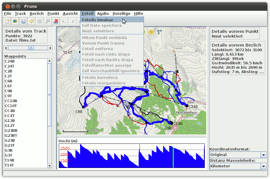
- <p>GpsPrune is an application for viewing, editing and converting
coordinate data from GPS systems. Basically it's a tool to let you play with
your GPS data after you get home from your trip.</p>
- <p>It can load data from arbitrary text-based formats (for example, any
tab-separated or comma-separated file) or Xml, or directly from a GPS receiver.
It can display the data (as map view using openstreetmap images and as altitude
profile), edit this data (for example delete points and ranges, sort waypoints,
compress tracks), and save the data (in various text-based formats). It can
also export data as a Gpx file, or as Kml/Kmz for import into Google Earth, or
send it to a GPS receiver.</p>
- <p>Some example uses of GpsPrune include cleaning up tracks by deleting
wayward points - either recorded by error or by unintended detours. It can also
be used to compare and combine tracks, convert to and from various formats,
compress tracks, export data to Google Earth, or to analyse data to calculate
distances, altitudes and so on.</p>
- </description>
- <screenshots>
- <screenshot type="default">
-
<image>https://activityworkshop.net/software/gpsprune/screengrabs/gpsprune_13_ordnance_survey.png</image>
- </screenshot>
- <screenshot>
-
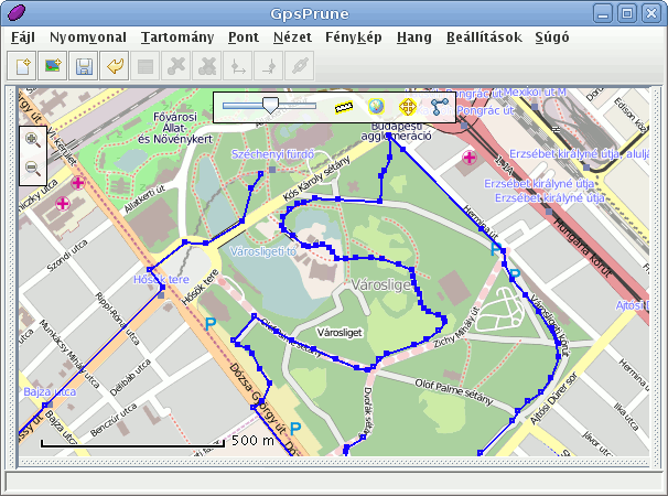
<image>https://activityworkshop.net/software/gpsprune/screengrabs/gpsprune_13_hungarian.png</image>
- </screenshot>
- <screenshot>
-
<image>https://activityworkshop.net/software/gpsprune/screengrabs/prune_12_ubuntu.png</image>
- </screenshot>
- </screenshots>
- <url
type="bugtracker">https://github.com/activityworkshop/GpsPrune/issues</url>
- <url type="homepage">https://activityworkshop.net/software/gpsprune/</url>
-</component>
Copied: gpsprune/repos/community-any/gpsprune.appdata.xml (from rev 1292703,
gpsprune/trunk/gpsprune.appdata.xml)
===================================================================
--- gpsprune.appdata.xml (rev 0)
+++ gpsprune.appdata.xml 2022-09-03 19:16:06 UTC (rev 1292704)
@@ -0,0 +1,27 @@
+<?xml version="1.0" encoding="UTF-8"?>
+<component type="desktop-application">
+ <id>net.activityworkshop.gpsprune</id>
+ <launchable type="desktop-id">gpsprune.desktop</launchable>
+ <name>GpsPrune</name>
+ <summary>Visualize, edit and prune GPS tracks</summary>
+ <metadata_license>CC0-1.0</metadata_license>
+ <project_license>GPL-2.0</project_license>
+ <description>
+ <p>GpsPrune is an application for viewing, editing and converting
coordinate data from GPS systems. Basically it's a tool to let you play with
your GPS data after you get home from your trip.</p>
+ <p>It can load data from arbitrary text-based formats (for example, any
tab-separated or comma-separated file) or Xml, or directly from a GPS receiver.
It can display the data (as map view using openstreetmap images and as altitude
profile), edit this data (for example delete points and ranges, sort waypoints,
compress tracks), and save the data (in various text-based formats). It can
also export data as a Gpx file, or as Kml/Kmz for import into Google Earth, or
send it to a GPS receiver.</p>
+ <p>Some example uses of GpsPrune include cleaning up tracks by deleting
wayward points - either recorded by error or by unintended detours. It can also
be used to compare and combine tracks, convert to and from various formats,
compress tracks, export data to Google Earth, or to analyse data to calculate
distances, altitudes and so on.</p>
+ </description>
+ <screenshots>
+ <screenshot type="default">
+
<image>https://activityworkshop.net/software/gpsprune/screengrabs/gpsprune_13_ordnance_survey.png</image>
+ </screenshot>
+ <screenshot>
+
<image>https://activityworkshop.net/software/gpsprune/screengrabs/gpsprune_13_hungarian.png</image>
+ </screenshot>
+ <screenshot>
+
<image>https://activityworkshop.net/software/gpsprune/screengrabs/prune_12_ubuntu.png</image>
+ </screenshot>
+ </screenshots>
+ <url
type="bugtracker">https://github.com/activityworkshop/GpsPrune/issues</url>
+ <url type="homepage">https://activityworkshop.net/software/gpsprune/</url>
+</component>
Deleted: gpsprune.desktop
===================================================================
--- gpsprune.desktop 2022-09-03 19:15:53 UTC (rev 1292703)
+++ gpsprune.desktop 2022-09-03 19:16:06 UTC (rev 1292704)
@@ -1,12 +0,0 @@
-[Desktop Entry]
-Version=1.0
-Name=GpsPrune
-Comment=Visualize, edit and prune GPS tracks
-Exec=gpsprune %F
-Icon=gpsprune
-Categories=Education;Science;Geoscience;
-StartupNotify=false
-Terminal=false
-Type=Application
-MimeType=application/gpx+xml;
-Keywords=gps;gpx;kml;kmz;tracks;waypoints;routes;
Copied: gpsprune/repos/community-any/gpsprune.desktop (from rev 1292703,
gpsprune/trunk/gpsprune.desktop)
===================================================================
--- gpsprune.desktop (rev 0)
+++ gpsprune.desktop 2022-09-03 19:16:06 UTC (rev 1292704)
@@ -0,0 +1,12 @@
+[Desktop Entry]
+Version=1.0
+Name=GpsPrune
+Comment=Visualize, edit and prune GPS tracks
+Exec=gpsprune %F
+Icon=gpsprune
+Categories=Education;Science;Geoscience;
+StartupNotify=false
+Terminal=false
+Type=Application
+MimeType=application/gpx+xml;
+Keywords=gps;gpx;kml;kmz;tracks;waypoints;routes;
Deleted: gpsprune.sh
===================================================================
--- gpsprune.sh 2022-09-03 19:15:53 UTC (rev 1292703)
+++ gpsprune.sh 2022-09-03 19:16:06 UTC (rev 1292704)
@@ -1,2 +0,0 @@
-#!/bin/bash
-java -jar /usr/share/java/gpsprune/gpsprune.jar "$@"
Copied: gpsprune/repos/community-any/gpsprune.sh (from rev 1292703,
gpsprune/trunk/gpsprune.sh)
===================================================================
--- gpsprune.sh (rev 0)
+++ gpsprune.sh 2022-09-03 19:16:06 UTC (rev 1292704)
@@ -0,0 +1,2 @@
+#!/bin/bash
+java -jar /usr/share/java/gpsprune/gpsprune.jar "$@"