I would like to restate my concern about describing the tri-polar grid as a
coordinate reference system, using the 'grid mapping' defined in approach in
5.6. Horizontal Coordinate Reference Systems, Grid Mappings, and Projections
and Appendix F Grid Mappings.
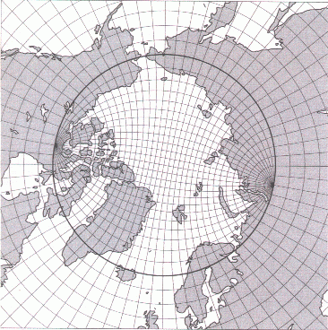
I do not think that the tri-polar grid is a Coordinate Reference System, unlike
all other entities defined in Appendix F.  I think that adding a tri-polar
definition here fundamentally alters the interpretation of 'grid mapping' and
has potentially significant implications for software providing capabilities to
work with grid mapping entities.
This would represent a significant change of scope for these aspects of the
Conventions document.

Currently all entries in Appendix F are either a Geographic Coordinate
Reference System or a Projected Coordinate Reference System.
The tri-polar grid is neither of these.
The mechanics of looking up the required longitude and latitude values for a
given x/i and y/j coordinate index are not mathematically similar to the
calculations for geographic or projected space

I think the CF community would do well to consider where else information
defining a tri-polar grid may be encoded in a file, and to keep the scope of
the Grid Mapping section constrained.

I saw Appendix D: Parametric Vertical Coordinates mentioned as well, all be it
in passing.  The tri-polar grid does not seem like a case of parametric
coordinates either, to me, even if the 'vertical' was relaxed.

I realise I am raising objections but not proposing solutions, I do not have an
easy answer here, I am afraid.

all the best
mark


________________________________________
From: CF-metadata [[email protected]] on behalf of Sebastien
Villaume [[email protected]]
Sent: 05 April 2017 19:20
To: Gregory, Jonathan
Cc: [email protected]
Subject: Re: [CF-metadata] CF compliant tripolar grid representation

Dear Jonathan,

I will try to look at Appendix F and come back with a proposal. I have a rough
idea of what I need but I have no clue what would be the proper terms for
those: extra attributes to describe north pole 1 and north pole 2, latitude
separating the "regular" from the irregular region, etc.

____________________________________

Dr. Sébastien Villaume
Analyst
ECMWF
Shinfield Park,
Reading RG2 9AX, UK
+44 7825 521592
[email protected]
____________________________________

----- Original Message -----
From: "Jonathan Gregory" <[email protected]>
To: [email protected]
Sent: Wednesday, 5 April, 2017 16:15:55
Subject: Re: [CF-metadata] CF compliant tripolar grid representation

Dear Sebastien

Apologies. I meant Appendix F (grid mappings) not D. Could you describe
your species of tripolar grid as one of these? Maybe there aren't any
parameters to be recorded.

Best wishes

Jonathan

----- Forwarded message from Sebastien Villaume <[email protected]>
-----

> Date: Wed, 5 Apr 2017 08:47:57 +0000
> From: Sebastien Villaume <[email protected]>
> To: [email protected]
> Subject: Re: [CF-metadata] CF compliant tripolar grid representation
> X-Mailer: Zimbra 8.6.0_GA_1200 (ZimbraWebClient - FF50 (Linux)/8.6.0_GA_1200)
>
> Hi all,
>
> I could try to draft an new entry in grid_mapping or a new entry in Appendix
> D (it will not be a dimensionless "vertical" coordinate but a dimensionless
> "horizontal" coordinate)
>
> Could we agree first on what I need to define? I don't want to invest too
> much time in defining something before everyone agree on the way forward.
>
> thanks
>
> ____________________________________
>
> Dr. Sébastien Villaume
> Analyst
> ECMWF Shinfield Park,
> Reading RG2 9AX, UK
> +44 7825 521592
> [email protected]
> ____________________________________
>
> ----- Original Message -----
> From: "Jim Biard" <[email protected]>
> To: [email protected]
> Sent: Tuesday, 4 April, 2017 21:47:36
> Subject: Re: [CF-metadata] CF compliant tripolar grid representation
>
> Hi.
>
> I tend to agree with Jonathan about the use of the grid_mapping variable,
> although it would probably be necessary to provide a clear distinction
> between this sort of information about mapping grid indices to lats and lons
> and providing information about mapping projected coordinate axis values to
> lats and lons. This new use is probably more appropriate for the name of the
> variable ( grid _mapping). Having said that, the potential for confusion and
> complication makes me wonder if a new construct isn't needed.
>
> The problem that I see with x/y_coordinate_index is that the indices are very
> likely indices to lat/lon coordinates, not x/y coordinates. They function as
> a sort of unitless, non-geographic x and y, but I think it would better to
> avoid overloading concepts. It's also possible that these indices could be
> indices to x and y coordinates, so it seems to me that
> lat/lon_coordinate_index would be no better. This is what led me to the names
> in my list that didn't use x, y, lat, or lon. They could be useful in other
> scenarios, such as satellite swath imagery, which have axes of scan and
> sample, so I didn't want to constrain the terms too closely to the mesh grid
> scenario that this discussion started with.
>
> Grace and peace,
>
> Jim
>
> On 4/4/17 4:25 PM, Jonathan Gregory wrote:
>
>
>
> Dear Sébastien et al.
>
> From what you say I understand that the translation of indices to coordinate
> values is rather ad-hoc, rather than being done by the same formulae for all
> sorts of tripolar grid. You could identify the grid construction, if that
> would
> be useful, in a non-standard way in some attribute such as "comment". To
> provide a standardised description, I still think grid_mapping would be the
> right place, but evidently "tripolar" would not be a sufficient definition.
> Instead you would need different entries in Appendix D for the different sorts
> of tripolar grid in use. In these entries you could certainly give URLs to
> documentation, I think, as well as a description. The aim of putting it in
> Appendix D would be to provide a source of information about how the indices
> are related to coordinate values.
>
> I suggested [xy]_coordinate_index because these phrases are already used in
> standard names (one of each). If we don't like them now, we ought to change
> the
> existing names, since we should be consistent. I think the phrase "coordinate
> index" means "the index to a coordinate value". Just "index" would be less
> informative, I feel.
>
> Best wishes
>
> Jonathan
>
>
> ----- Forwarded message from Sebastien Villaume
> <[email protected]> -----
>
>
>
> Date: Mon, 3 Apr 2017 13:56:40 +0000
> From: Sebastien Villaume <[email protected]> To:
> [email protected] Subject: Re: [CF-metadata] CF compliant tripolar
> grid representation
> X-Mailer: Zimbra 8.6.0_GA_1200 (ZimbraWebClient - FF50 (Linux)/8.6.0_GA_1200)
>
>
> Hi Mark,
>
> I agree that we need to find the best way to describe these grids (with the
> appropriate controlled metadata) and not necessarily use an existing concept
> (crs, grid_mapping) if it does not fit the purpose and generates confusion.
>
> These tripolar grids are tricky and I guess this is why there is no standard
> systematic way to describe them.
>
> Reading more on it, I realized that some of them are not always "regular
> grids" (by regular I mean monotonic increase of lat and lon when increasing i
> and j indices): it seems that some NEMO configurations reuse some of the i
> and j indices that are over land (large parts of Asia and Africa) and
> relocate them over specific water regions to locally increase the grid
> resolution!
>
> This can be seen here:
> http://www.nemo-ocean.eu/content/download/7538/40914/file/meshmask_grid.pdf
> Some of these grids do not have a simple analytical description since it is a
> composite of several local descriptions. How can I then properly
> reference/identify them? using an attribute like "model_grid_mapping" or
> "model_mesh_mapping" or simply "mesh_mapping" instead of "grid_mapping" and
> points to an URN/URI?
>
> AMy main issue is that I can not derive directly from the metadata the type
> of grid used. I have to plot it to know what it is and this is not
> satisfactory.
>
> Regardless of the preferred solution (if one exists), I would still like to
> have a proper standard name for my 1-D mesh indices i and j.
>
> thanks
> ____________________________________
>
> Dr. Sébastien Villaume
> Analyst
> ECMWF Shinfield Park,
> Reading RG2 9AX, UK
> +44 7825 521592 [email protected]
> ____________________________________
>
> ----- Original Message -----
> From: "Hedley, Mark" <[email protected]> To: "Jim Biard"
> <[email protected]> , [email protected] Sent: Monday, 3 April, 2017
> 10:28:05
> Subject: Re: [CF-metadata] CF compliant tripolar grid representation
>
> Hello All,
>
> I'd like to pick up on an earlier comment from Jim:
> If I'm not mistaken, we would need to propose a new grid_mapping to be
> added to the Conventions that would define a Tripolar Coordinate Reference
> System, along with any attributes that don't currently exist that are
> needed to complete the definition. I did a search for a standard tripolar
> CRS in proj4 or epsg, and was unable to find one. Is it possible to make
> such a definition?
> I don't think this is the correct approach
>
> In my opinion, the tri-polar grid is described with respect to a Geographic
> Coordinate Reference System: typically the one used to co-locate the
> observations for assimilation, by spatial coordinates.
> The 'Grid' is not a projection and it is not a coordinate reference system:
> it is the description of a model grid.
> In data files I have seen, each spatial location is defined by a location in
> latitude, longitude and depth, with respect to a suitable geodetic datum.
>
>
> I agree with your more recent comment Jim:
>
> I'm wondering if x and y have too strong an association to projected
> coordinate
> systems. I also like u/v, but that may be too strongly associated for some
> people
> with vector components (wind, for example).
>
> I think that describing grid indices should be carefully distinguished from
> spatial coordinates. Put a different way, I don't think a grid index can be
> georeferenceable.
>
> I think that a good deal of care not to confuse the grid indices with any
> interpretation of 'grid_mapping' relations is required here.
> I don't think that a CF grid mapping should be used to connect any
> description of model index space with geographic space in these cases.
>
> Sebastien states:
>
> I would like to propose for addition standard names to support the mesh
> indices/coordinates:
>
> "mesh_grid_i/j_index" suggested by Jim
> or
> "x/y_coordinate_index" suggested by Jonathan
>
> The mixing of the terms coordinate and index gives me pause for thought. What
> information is being encoded here?
>
> A key question I have is about the expectation for values of these indices,
> under operations such as sub-setting. I have seen many files which do not
> have coordinate variables for the x-like and y-like dimensions, the only
> horizontal spatial metadata is contained in auxiliary coordinates.
> Clearly I can perform index operations on these arrays, but I don't consider
> the index values important and I don't preserve them.
>
> Sebastien:
> Is it the case that you would like to ensure that model index space values
> are preserved, for example when removing a regional subset from a tri-polar
> ocean model?
> Would you like to be able to encode a result where it is clear that a
> regional subset of 50 <= x < 150, 70 <= x < 120 has been taken from a larger
> extent model?
>
> If standard names are provided to encode such information, I would advocate
> clear descriptive text stating that there is no mathematical relationship
> between such index coordinates (i still don't like mixing these terms) and
> projection coordinates or geographic coordinates
>
> Sebastien states:
> I have checked both IPSL and CNRM CMIP5 datasets. It is indeed NEMO datasets
> and it is probably a
> ORCA tripolar grid in both cases. I write "probably" because it is not clear
> and conclusive
> without plotting the datasets: lat and lon are 2D fields, the datasets define
> 2 extra 1D coordinates "i" and "j"
> to be used as mesh indices (but without a proper standard name).
> The datasets also have bounds for lat and lon, defined as "lat_vertices" and
> "lon_vertices" which I think
> is one solution to describe the tripolar grid. I would prefer something more
> standardized and documented so
> that one can quickly identify from the metadata that it is a tripolar grid
> (defining the resolution,
> where are the poles, how it is derived, etc.)
>
> I appreciate the desire to have a standardised approach to defining such a
> model grid. I would not advocate trying to use grid mapping variables
> and relationships for this, I think this could do more harm than good.
> I don't have a better suggestion to hand, I'm sad to say.
>
> I am not raising principled objections to this conversation or the direction
> of travel; I am raising waryness and caution about introducing further
> confusion or implying stronger relationships than can be provided.
>
> all the best
> mark
>
>
> From: CF-metadata [ [email protected] ] on behalf of Jim Biard
> [ [email protected] ]
> Sent: 31 March 2017 23:26
> To: [email protected] Subject: Re: [CF-metadata] CF compliant tripolar
> grid representation
>
>
>
> Hi.
>
> I like the more generic x/y_coordinate_index name, but I'm wondering if x and
> y have too strong an association to projected coordinate systems. I also like
> u/v, but that may be too strongly associated for some people with vector
> components (wind, for example). What do the rest of you think? Here are some
> names that come to mind. Feel free to suggest something better!
>
>
>     * mesh_grid_i_index, mesh_grid_j_index
>     * grid_i_index, grid_j_index
>     * grid_i_coordinate, grid_j_coordinate
>     * x_coordinate_index, y_coordinate_index
>     * index_x_coordinate, index_y_coordinate (this ordering matches the
> projection_x/y_coordinate naming)
>     * u_coordinate, v_coordinate
>     * i_coordinate, j_coordinate
>     * grid_row_coordinate, grid_column_coordinate
>     * row_coordinate, column_coordinate
>
>
> The more I look at these, the more I like the last two.
>
>
> As for a definitions, how about something like this variation on the ones for
> the projection_x/y_coordinate?
>
>
>
>
> column_coordinate: "column" indicates the fastest-changing dimension of a
> two-dimensional grid, when this is not associated with a spatial coordinate
> dimension such as longitude or projected X, positive with increasing column.
> The column coordinate, possibly in conjunction with the row coordinate,
> serves as a parametric driver mapping abstract grid positions to spatial
> coordinates such as latitude and longitude.
>
>
> row_coordinate: "row" indicates the the slowest-changing dimension of a
> 2-dimensional grid, when this is not associated with a spatial coordinate
> dimension such as latitude or projected Y, positive with increasing row. The
> row and column coordinates serve as a parametric driver mapping abstract grid
> positions to spatial coordinates such as latitude and longitude. Grace and
> peace,
>
> Jim
>
> On 3/31/17 5:37 PM, Sebastien Villaume wrote:
>
>
>
> Hi all,
>
> I have checked both IPSL and CNRM CMIP5 datasets. It is indeed NEMO datasets
> and it is probably a ORCA tripolar grid in both cases. I write "probably"
> because it is not clear and conclusive without plotting the datasets: lat and
> lon are 2D fields, the datasets define 2 extra 1D coordinates "i" and "j" to
> be used as mesh indices (but without a proper standard name). The datasets
> also have bounds for lat and lon, defined as "lat_vertices" and
> "lon_vertices" which I think is one solution to describe the tripolar grid. I
> would prefer something more standardized and documented so that one can
> quickly identify from the metadata that it is a tripolar grid (defining the
> resolution, where are the poles, how it is derived, etc.)
>
> I would like to propose for addition standard names to support the mesh
> indices/coordinates:
>
> "mesh_grid_i/j_index" suggested by Jim
> or
> "x/y_coordinate_index" suggested by Jonathan
>
> I let the experts in standard names decide which pair suits best the present
> case.
>
> Regarding tripolar grids characteristics, I did some research and came to the
> conclusion that "Murray tripolar grids" are not identical to "ORCA/NEMO
> tripolar grids". This is true even without considering characteristics like
> the grid resolution, the location of the poles or where the latitude boundary
> is placed between the modified and unmodified parts.
>
> The Murray tripolar grid (used by GFDL) has its "north" poles on the boundary
> as shown here:
> https://www.gfdl.noaa.gov/wp-content/uploads/pix/user_images/mw/bipolar.gif
> The ORCA/NEMO tripolar grids have the "north" poles within the modified
> regions but not on the boundary as shown in my original post:
> http://www.geomar.de/typo3temp/pics/globe_grid2_14_b8edb639ae.png This
> complicates things...
>
>
> ____________________________________
>
> Dr. Sébastien Villaume
> Analyst
> ECMWF Shinfield Park,
> Reading RG2 9AX, UK
> +44 7825 521592 [email protected]
> ____________________________________
>
> ----- Original Message -----
> From: "James Orr" <[email protected]> To: "Karl Taylor"
> <[email protected]> Cc: [email protected] Sent: Thursday, 30 March,
> 2017 23:01:54
> Subject: Re: [CF-metadata] CF compliant tripolar grid representation
>
> The IPSL and CNRM cimate models that participated in CMIP5 both used the NEMO
> model (ORCA2 and ORCA1 configurations) with tripolar grids.  Both provided
> output the was CF compliant.
>
> James
>
> On Thu, 30 Mar 2017, Karl Taylor wrote:
>
>
>
> Hi Sebastien,
>
> More than one group stored output on a tripolar grid in CMIP5.  I'm pretty
> sure they did it in a CF-conforming way.  I know at least some of the GFDL
> model output was reported on a tripolar grid, as described at
> http://nomads.gfdl.noaa.gov/CM2.X/oceangrid.html (or search on "tripolar
> grid" for additional links).  You could look to their example, and see if you
> think it is done correctly.
>
> I don't think extensions or modifications to CF are needed for tripolar
> grids.
>
> best regards,
> Karl
>
> On 3/30/17 9:42 AM, Jim Biard wrote:
>
>
>
> Sébastien,
>
> If I'm not mistaken, we would need to propose a new grid_mapping to be
> added to the Conventions that would define a Tripolar Coordinate Reference
> System, along with any attributes that don't currently exist that are
> needed to complete the definition. I did a search for a standard tripolar
> CRS in proj4 or epsg, and was unable to find one. Is it possible to make
> such a definition?
>
> Regarding the standard names for your X and Y coordinate variables, I think
> you could use "projection_x/y_coordinate" once a grid_mapping has been
> defined. Of course you could always leave the attribute off, since a
> standard_name attribute is not a requirement.
>
> If making a new grid_mapping is not feasible, you could request standard
> names along the lines of mesh_grid_i_index and mesh_grid_j_index. These
> standard names would (on reading their definitions) make it clear that the
> measurements are on a mesh grid for which there is no CRS. At least that's
> what comes to mind at the moment.
>
> Grace and peace,
>
> Jim
>
> On 3/30/17 11:52 AM, Sebastien Villaume wrote:
>
>
>
> Hello all,
>
> I am looking for the best approach to describe in a CF compliant way the
> tripolar grids usually used in NEMO configurations.
>
> Basically, the difference with a usual bipolar grid (north pole-south
> pole) is that the north pole is split into 2 poles moved over Canada and
> Russia (to have distortions/singularities not over the ocean). A good
> visual representation can be found here:
> http://www.geomar.de/typo3temp/pics/globe_grid2_14_b8edb639ae.png everything
> south of the green line (40degN) is identical to a regular
> grid, but everything north of it is computed using a technique described
> here:
>
> Madec, G. and M. Imbard, 1996 : A global ocean mesh to overcome the north
> pole singularity. Clim. Dyn., 12, 381–388.
>
>
> The usual NEMO output of the grid looks like this:
>
>      float longitude(y, x) ;
>          longitude:standard_name = "longitude" ;
>          longitude:units = "degrees_east" ;
>          longitude:long_name = "longitude" ;
>      float latitude(y, x) ;
>          latitude:standard_name = "latitude" ;
>          latitude:units = "degrees_north" ;
>          latitude:long_name = "latitude" ;
>
>
> Basically both latitudes and longitudes need to be specified for each grid
> point, hence lat and lon are 2D arrays. This is not a problem itself but I
> would like to give more information through maybe grid_mapping or crs so
> it is clear that the grid is tripolar. This is useful information if one
> want to project/interpolate this back to a more regular representation.
>
> Looking at the CF conventions, I can see that grids can be fairly nicely
> documented but nothing for tripolar grids.
>
> Is there some documentation/guidelines on how to derive a proper
> grid_mapping/crs with valid attributes for tripolar grids?
>
> I would also like to add to my netcdf file a way to better describe axes:
>
>      double y(y) ;
>          y:units = "1" ;
>          y:long_name = "j-index of mesh grid" ;
>          y:standard_name = ??? ;
>      double x(x) ;
>          x:units = "1" ;
>          x:long_name = "i-index of mesh grid" ;
>          x:standard_name = ??? ;
>
> what would be the standard name of these?
>
> Thanks,
>
> ____________________________________
>
> Dr. Sébastien Villaume
> Analyst
> ECMWF Shinfield Park,
> Reading RG2 9AX, UK
> +44 7825 521592 [email protected]
> ____________________________________
> _______________________________________________
> CF-metadata mailing list [email protected]
> http://mailman.cgd.ucar.edu/mailman/listinfo/cf-metadata --
> CICS-NC <http://www.cicsnc.org/> Visit us on
> Facebook <http://www.facebook.com/cicsnc> *Jim Biard*
> *Research Scholar*
> Cooperative Institute for Climate and Satellites NC <http://cicsnc.org/>
> North Carolina State University <http://ncsu.edu/> NOAA National Centers for
> Environmental Information <http://ncdc.noaa.gov/> /formerly NOAA’s National
> Climatic Data Center/
> 151 Patton Ave, Asheville, NC 28801
> e: [email protected] <mailto:[email protected]> o: +1 828 271 4900
>
> /Connect with us on Facebook for climate
> <https://www.facebook.com/NOAANCEIclimate> and ocean and geophysics
> <https://www.facebook.com/NOAANCEIoceangeo> information, and follow us on
> Twitter at @NOAANCEIclimate <https://twitter.com/NOAANCEIclimate> and
> @NOAANCEIocngeo <https://twitter.com/NOAANCEIocngeo> . /
>
>
>
>
> _______________________________________________
> CF-metadata mailing list [email protected]
> http://mailman.cgd.ucar.edu/mailman/listinfo/cf-metadata --
>
>       Visit us on
> Facebook      Jim Biard
> Research Scholar
> Cooperative Institute for Climate and Satellites NC
> North Carolina State University
> NOAA National Centers for Environmental Information
> formerly NOAA’s National Climatic Data Center
> 151 Patton Ave, Asheville, NC 28801
> e: [email protected] o: +1 828 271 4900
>
> Connect with us on Facebook for climate and ocean and geophysics information,
> and follow us on Twitter at @NOAANCEIclimate and @NOAANCEIocngeo .
>
> _______________________________________________
> CF-metadata mailing list [email protected]
> http://mailman.cgd.ucar.edu/mailman/listinfo/cf-metadata
>
>
>
> _______________________________________________
> CF-metadata mailing list [email protected]
> http://mailman.cgd.ucar.edu/mailman/listinfo/cf-metadata
> ----- End forwarded message -----
> _______________________________________________
> CF-metadata mailing list [email protected]
> http://mailman.cgd.ucar.edu/mailman/listinfo/cf-metadata
>
> --
>
>       Visit us on
> Facebook      Jim Biard
> Research Scholar
> Cooperative Institute for Climate and Satellites NC
> North Carolina State University
> NOAA National Centers for Environmental Information
> formerly NOAA’s National Climatic Data Center
> 151 Patton Ave, Asheville, NC 28801
> e: [email protected]
> o: +1 828 271 4900
>
> Connect with us on Facebook for climate and ocean and geophysics information,
> and follow us on Twitter at @NOAANCEIclimate and @NOAANCEIocngeo .
>
> _______________________________________________
> CF-metadata mailing list
> [email protected]
> http://mailman.cgd.ucar.edu/mailman/listinfo/cf-metadata


> _______________________________________________
> CF-metadata mailing list
> [email protected]
> http://mailman.cgd.ucar.edu/mailman/listinfo/cf-metadata


----- End forwarded message -----
_______________________________________________
CF-metadata mailing list
[email protected]
http://mailman.cgd.ucar.edu/mailman/listinfo/cf-metadata
_______________________________________________
CF-metadata mailing list
[email protected]
http://mailman.cgd.ucar.edu/mailman/listinfo/cf-metadata
_______________________________________________
CF-metadata mailing list
[email protected]
http://mailman.cgd.ucar.edu/mailman/listinfo/cf-metadata