Bob, I'd like to mirror Paul and Christopher's comments.
There are a lot of browser based mapping clients available, many of them
Open Source.
From a user's point of view, this is confusing rather than useful.
"Should I get features A,B,C,D or A,C,E,G?"
Where possible, common libraries should be extracted from projects,
allowing developers to focus on other problems.
However, emotionally it is hard to merge two or more projects. If two
projects merge together, roughly half of each project code should be
thrown away.
As Chris noted, Mapbuilder is in the process of merging OpenLayers into
its codebase. This involves throwing away a lot of our original code,
but at the same time, makes Mapbuilder a more robust product because we
can focus on other areas.
Christopher Schmidt wrote:
On Wed, Feb 28, 2007 at 02:22:37PM -0600, Bob Basques wrote:
Paul,

It's funny you put it the way you did.  From an Email exchange today
about how our project compares ti OpenLayers :

This is how I see them as being different.  Others, feel free to chime
in.

Moose has more of the Desktop GIS functionality and more tightly
integrated with MapServer. For example: measure, data popups, graphic
design skins, move layers, legends, printing, more configuration
options, identify, and select.  I don't think this type of
functionality
is the goal of OpenLayers, they strive more to make it easy to
integrate
multiple data sources.
Although this is not in the goal of the *core* of OpenLayers, building
the application on *top* of OpenLayers (assuming that you're searching
for a web interface) is exactly what OpenLayers is targeted to. The
examples directory of OpenLayers contains an example for how to do
feature identification/query
(http://openlayers.org/dev/examples/getfeatureinfo.html), and path
measuring is one of the tools that the new vector integration will allow
us to build.

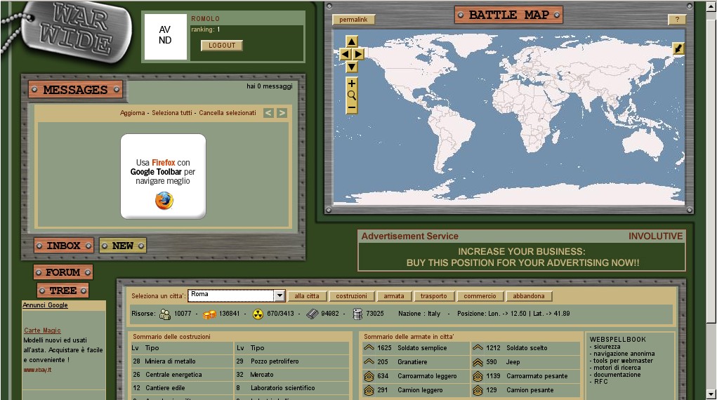
Styling the OpenLayers UI and integrating it into a larger surrounding
UI is also part of the design of the project:
http://www.warwide.com/images/wwscreen/wwss_01.jpg shows, for example,
an OpenLayers interface integrated into a war game.

Moving layers is something that there is no existing UI for, but
something that I would love to see, either as an example or as an
external control. However, at the moment it is true that we're
concentrating on how to get data into the interface.

In general, OpenLayers seeks to create an API which can be used at the
base level of any browser-based GIS application. MapBuilder has already
begun to use the OpenLayers API to replace their existing map renderer,
by building their tools around an OpenLayers Map created via that API.
ka-Map may do something similar in the future.
OpenLayers strives to have easy support for numerous data sources like
Google, Yahoo, GeoRSS, and WMS.  Then they work off of the concept of
placing point markers and soon vector (line and polygon) on top of
those
data sources.  The also support tiled and untiled data sources in the
same interface.  This works very nice if your don't have a lot of
layers
that are changing all the time and you can make use of caching.  I
think
an interface like this would be pretty slow and hard to manage for a
organization like Douglas County, MN that is updating their parcels,
plats, E911 address points and roads every week.
I'm not sure how you're going to be able to improve that -- I'd be
interested to learn more about what you feel the challenges are that
OpenLayers doesn't help you meet.
A more discrete description might be that MOOSE is shooting for the
customers that need to publish data in all sort of formats (and legacy
Systems), in a near Realtime fashion.  The intent is to make the process
as transparent to the Data publishers as it is to the Data users.
I'm slightly confused, now. You mention 'publish their data', which to
me, sounds like a server, rather than a client. Clients consume
published data. OpenLayers is a client. Mapserver, GeoServer,
ka-Map, TileCache, WorldWind are servers. Which is MOOSE?
Regards,
--
Cameron Shorter
Systems Architect, http://lisasoft.com.au
Tel: +61 (0)2 8570 5011
Mob: +61 (0)419 142 254

_______________________________________________
Discuss mailing list
[email protected]
http://lists.osgeo.org/mailman/listinfo/discuss