I need a mantra so I can submit QGIS issues please! Thank you!

JASON M WHEATLEY, MS, GISP
CENTURY ENGINEERING, INC.
p. 443.589.2400 x1465     www.centuryeng.com
c. 443.880.0189
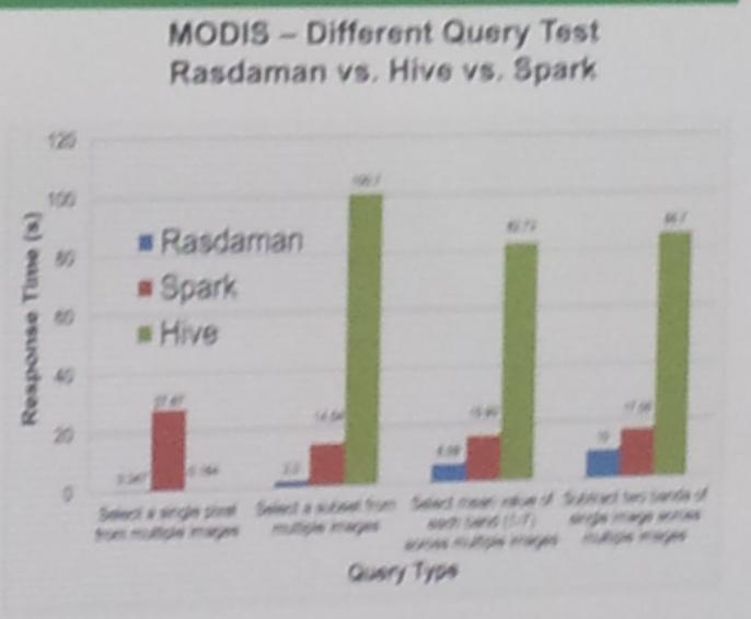
-----Original Message-----
From: Discuss [mailto:[email protected]] On Behalf Of
[email protected]
Sent: Friday, May 20, 2016 3:00 PM
To: [email protected]
Subject: Discuss Digest, Vol 113, Issue 20

Send Discuss mailing list submissions to
        [email protected]

To subscribe or unsubscribe via the World Wide Web, visit
        http://lists.osgeo.org/mailman/listinfo/discuss
or, via email, send a message with subject or body 'help' to
        [email protected]

You can reach the person managing the list at
        [email protected]

When replying, please edit your Subject line so it is more specific than "Re:
Contents of Discuss digest..."


Today's Topics:

   1. Re: Mantra request (OsgeoID) (Sandro Santilli)
   2. Re: Adding "wiki" component to osgeo trac ? (Sandro Santilli)
   3. Does rasdaman CE solve an open source geospatial  problem?
      (Edzer Pebesma)
   4. Re: Tales from a Benevolent Dictator (Peter Baumann)
   5. gvSIG Festival: webinars in English (SERGIO ACOSTAYLARA)


----------------------------------------------------------------------

Message: 1
Date: Thu, 19 May 2016 21:32:14 +0200
From: Sandro Santilli <[email protected]>
To: Johan Van de Wauw <[email protected]>
Cc: Yves Jacolin <[email protected]>, OSGeo Discussions
        <[email protected]>, Frank Olieu <[email protected]>
Subject: Re: [OSGeo-Discuss] Mantra request (OsgeoID)
Message-ID: <20160519193214.GC23969@localhost>
Content-Type: text/plain; charset=us-ascii

On Thu, May 19, 2016 at 06:27:16PM +0200, Johan Van de Wauw wrote:
> Maybe the mantra should be posted to this list with a link to this
> discussion. I'm quite sure that blocks most spam and removes a barrier
> to reporting a bug/contributing.
>
> Now people have to register for the mailinglist, confirm. Ask for a pw.
> Wait for it. Register. Confirm ...

You can also ask for the mantra on IRC, with no registration required there. Or
(we could add this info to the page) people may ask for the mantra to someone
from the project they are registering to contribute to.

--strk;


------------------------------

Message: 2
Date: Thu, 19 May 2016 21:38:03 +0200
From: Sandro Santilli <[email protected]>
To: Christian Willmes <[email protected]>
Cc: [email protected]
Subject: Re: [OSGeo-Discuss] Adding "wiki" component to osgeo trac ?
Message-ID: <20160519193803.GD23969@localhost>
Content-Type: text/plain; charset=us-ascii

On Thu, May 19, 2016 at 06:21:47PM +0200, Christian Willmes wrote:
> +1
>
> Yes, sounds like a good Idea to give an opportunity for requesting
> features and reporting bugs.

Great.
Component added and some tickets moved to it (for testing).
I'm not sure you'll receive notifications, due to
https://trac.osgeo.org/osgeo/ticket/1671, do you ?

There are many more tickets that belong to the "Wiki" component.
This is a list of all the ones with "wiki" in the title, in case you want to
move some to the new component:
https://trac.osgeo.org/osgeo/query?status=assigned&status=new&status=reopened&summary=~wiki&col=id&col=summary&col=status&col=type&col=priority&col=milestone&col=component&order=priority

--strk;


------------------------------

Message: 3
Date: Fri, 20 May 2016 09:30:13 +0200
From: Edzer Pebesma <[email protected]>
To: [email protected]
Subject: [OSGeo-Discuss] Does rasdaman CE solve an open source
        geospatial      problem?
Message-ID: <[email protected]>
Content-Type: text/plain; charset="utf-8"

As a scientist, I teach my students that for doing science it is a requirement
to work with open source software, because only then workflows are fully
transparent and can be reproduced by other scientists without prohibitive
license costs. Currently, working with large amounts of earth observation (EO)
or climate model data typically requires to download these data tile by tile,
stitch them together, and go through all of them. Array databases may simplify
this substantially: after ingesting the tiles, they can directly work on the
whole data as a multi-dimensinal array ("data cube").
Computations on these array are typically embarassingly parallel, and scale up
with the number of cores in a cluster.

Rasdaman is an array data base that comes in two flavours, the open source
community edition (CE) and the commercial enterprise edition (EE). The
differences between the two are clear [1]. When I want to use rasdaman CE (open
source) for scalable image analysis, I get stuck waiting for one core to finish
everything [1]. This is not going to solve any problems related to computing on
large data, and is not scalable. The bold claim that rasdaman.org opens with
("This worldwide leading array analytics engine distinguishes itself by its
flexibility, performance, and scalability") is not true for the CE advertised.
This has been mentioned in the past on mailing lists [2,3], but the typical
answer from Peter Baumann diverts into other arguments. Also the benchmark
graph (photo from an AGU poster) [4] that Peter sent this week [5] must refer
to the enterprise edition, since Spark and Hive both scale, but rasdaman CE
does not [3].

I assume that on the discussions on this list, ONLY the open source community
edition is considered, compared, and discussed, as a potential future OSGeo
project.

OSGeo supports the needs of the open source geospatial community [6].

Given

 * the bold claims and continuing confusion about whether,
   and which, rasdaman is scalable,
 * the need for OSGeo to give good advice to prospective users
   about technologies that do scale EO data analysis,
 * the current (unfilled!) needs of scientists for good, open source
   software for such analysis, and
 * the potential conflict of interest of its creator [7],

I wonder wether OSGeo should recommend rasdaman CE to the open source
geospatial community.


[1] http://rasdaman.org/wiki/Features
[2] https://lists.osgeo.org/pipermail/incubator/2014-October/002540.html
[3] https://groups.google.com/forum/#!topic/rasdaman-users/66XL3tmDDQI
[4]
https://lists.osgeo.org/pipermail/discuss/attachments/20160515/49200cd4/attachment.jpg
[5] https://lists.osgeo.org/pipermail/discuss/2016-May/016099.html
[6] http://www.osgeo.org/content/faq/foundation_faq.html
[7] https://lists.osgeo.org/pipermail/discuss/2016-May/016045.html
--
Edzer Pebesma
Institute for Geoinformatics  (ifgi),  University of Münster Heisenbergstraße
2, 48149 Münster, Germany; +49 251 83 33081
Journal of Statistical Software:   http://www.jstatsoft.org/
Computers & Geosciences:   http://elsevier.com/locate/cageo/
Spatial Statistics Society http://www.spatialstatistics.info

-------------- next part --------------
A non-text attachment was scrubbed...
Name: signature.asc
Type: application/pgp-signature
Size: 490 bytes
Desc: OpenPGP digital signature
URL:
<http://lists.osgeo.org/pipermail/discuss/attachments/20160520/e38df4d8/attachment-0001.sig>

------------------------------

Message: 4
Date: Fri, 20 May 2016 12:39:16 +0200
From: Peter Baumann <[email protected]>
To: Moritz Lennert <[email protected]>, Marco Afonso
        <[email protected]>, Anita Graser <[email protected]>
Cc: osgeo-discuss <[email protected]>
Subject: Re: [OSGeo-Discuss] Tales from a Benevolent Dictator
Message-ID: <[email protected]>
Content-Type: text/plain; charset="utf-8"

Hi all-
there is a bunch brilliant people to carry on "after me", should that be the
concern.
-Peter

On 05/15/2016 03:30 PM, Moritz Lennert wrote:
> On 15/05/16 14:40, Marco Afonso wrote:
>> Hi Anita,
>>
>> Aha! So there is a ponderation weight on software quality evaluation
>> AND project organization evaluation.
>>
>> So you can exclude an open source software with high quality if their
>> organization evaluation is low.
>>
>> For me that seems wrong. A software on a public repository is only
>> limited by it's licence terms, or unlimited at all. :)
>
> But the discussion is not about whether the software should be in a
> public repository or not, or what the licence term should be. The
> discussion is about what the meaning of the "OSGeo project" label is.
>
> I don't think anyone has questioned the quality of the software, here.
> However, one of the aims of labeling a project an OSGeo project is to
> give a certain level of guarantee to potential users that this
> software _project_ respects a series of criteria that are considered
> important to ensure a long-term sustainability of that project.
> Putting one person's name in the statutes of a project and designating
> that person as the one who has ultimate decision rights (even if these
> decisions are always based on quality criteria), leaves the question
> of what would happen if that person lands under the proverbial bus.
>
> A more collective governance structure is seen by many as more
> sustainable in the long run. Similar debates have gone on for ages in
> Debian, for example, about team-based maintaining of packages vs individual
> maintainers.
>
> What I personally haven't really understood, yet, is what the rasdaman
> community is really afraid of. If the community works as well as
> described, why would the creation of a PSC-like structure create such
> problems ?
>
> Moritz
> _______________________________________________
> Discuss mailing list
> [email protected]
> http://lists.osgeo.org/mailman/listinfo/discuss

--
Dr. Peter Baumann
 - Professor of Computer Science, Jacobs University Bremen
   www.faculty.jacobs-university.de/pbaumann
   mail: [email protected]
   tel: +49-421-200-3178, fax: +49-421-200-493178
 - Executive Director, rasdaman GmbH Bremen (HRB 26793)
   www.rasdaman.com, mail: [email protected]
   tel: 0800-rasdaman, fax: 0800-rasdafax, mobile: +49-173-5837882 "Si forte in
alienas manus oberraverit hec peregrina epistola incertis ventis dimissa, sed
Deo commendata, precamur ut ei reddatur cui soli destinata, nec preripiat
quisquam non sibi parata." (mail disclaimer, AD 1083)


------------------------------

Message: 5
Date: Fri, 20 May 2016 14:25:28 +0000
From: SERGIO ACOSTAYLARA <[email protected]>
To: "[email protected]" <[email protected]>,
        "[email protected]" <[email protected]>
Subject: [OSGeo-Discuss] gvSIG Festival: webinars in English
Message-ID: <[email protected]>
Content-Type: text/plain; charset="iso-8859-1"

Sorry for cross-posting

https://blog.gvsig.org/2016/05/18/gvsig-festival-webinars-in-english/?

Regards,


Sergio Acosta y Lara
Departamento de Geomática
Dirección Nacional de Topografía
Ministerio de Transporte y Obras Públicas
URUGUAY
-------------- next part --------------
An HTML attachment was scrubbed...
URL:
<http://lists.osgeo.org/pipermail/discuss/attachments/20160520/2333d138/attachment-0001.html>

------------------------------

Subject: Digest Footer

_______________________________________________
Discuss mailing list
[email protected]
http://lists.osgeo.org/mailman/listinfo/discuss

------------------------------

End of Discuss Digest, Vol 113, Issue 20
****************************************
_______________________________________________
Discuss mailing list
[email protected]
http://lists.osgeo.org/mailman/listinfo/discuss