Hi Mark and others,

I figured out where the error I'm getting from v.net.components is coming
from. I just don't know how to fix it.
The problem is that when I clean my roads network it's breaking some lines
and these are kept with the same categories. So when I run v.net.components
it tries to calculate the connectivity of the components based on the cat
value. Since there are some repeated values for broken roads, it can't
continue. So I believe I need to get new cat values for the network. Just
don't know ow to do it (been away from GRASS for a while)...
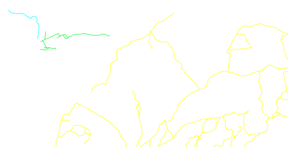
How can I get new cat values? And can I keep the old values in order to
keep the DB link to the roads network?

Cheers
Daniel

On Fri, Jan 16, 2015 at 3:35 PM, Daniel Victoria <[email protected]>
wrote:

> Hi Mark,
>
> I tried using v.clean with break, rmdup and snap. However, when I try to
> run v.net.components I get an error saying that
>
> v.net.components input=rede_brk_rmdup_snap@PERMANENT node_layer=1
> output=component_brk_rmdup_snap method=weak
> Building graph...
> Registering arcs...
> Flattening the graph...
> Graph was built
> ERROR: Cannot insert new record: insert into component_brk_rmdup_snap
> values (3689, 1)
>
> I'm using Grass v7RC1 on Windows and v.net.components work if I use only
> the snap tool in my roads network
>
> Cheers
> Daniel
>
> On Thu, Jan 15, 2015 at 7:40 PM, Mark Wynter <[email protected]>
> wrote:
>
>> Hi Daniel
>> When you ran v.clean, did you v.clean tool=break,rmdupl ?
>>
>> I suspect you still may encounter a problem with road T junctions if the
>> vectors don't cross or intersect.  Take this simple example of 2 roads -
>> NS, and EW.  Each line has only 2 nodes - at the line’s  start and end
>> points.
>> |—
>> The problem is when the horizontal line “undershoots” the vertical line.
>> The break command will have no effect, and snapping won’t make any
>> difference because there is no midpoint node to which the horizontal line
>> can attach itself to.
>>
>> I’d be interested to hear how others have dealt with what is essentially
>> a “data preparation” issue in GRASS?
>>
>> [The solution I ended up implementing used a PostGIS SQL custom function
>> to “break” overshoots and undershoots, with rules for correct treatment of
>> bridges and tunnels. The function is fast, and can be run in parallel when
>> working with continental-sized road networks.
>> After PostGIS, I import the “broken-up” network into GRASS and use
>> v.clean to snap the nodes, but NOT break the lines - as my PostGIS function
>> has already dealt with this.
>> The GRASS procedure involves running the v.clean in 5 steps, to avoid
>> inadvertently snapping a tunnel node to say a bridge node, just because
>> they are spatially close.
>> 1) v.clean tool=snap # no bridges, no tunnels
>> 2) v.clean tool=snap # bridges only
>> 3) v.clean tool=snap # tunnels only
>> 4) v.patch (steps 1-3)
>> 5) v.clean tool=snap # on the patched layer, with a much smaller
>> tolerance to that used in steps 1-3 to again avoid say tunnel nodes
>> inadvertently snapping to bridge nodes.
>> We’re then good to go with v.net analysis.]
>>
>> This may sound like a complicated process, but when using imperfect data
>> to model complex road networks in dense urban areas, its important to get
>> the vector topology as close as possible to the real world.  I’ve found
>> this process generates a highly representative, routable vector topology
>> from imperfect OSM data.
>>
>> Your situation might be much simpler, which is not to say you won’t
>> encounter anomalies like you’ve already identified.
>>
>> Mark
>>
>>
>>
>> ----------------------------------------------------------------------
>>
>> Message: 1
>> Date: Thu, 15 Jan 2015 15:22:27 -0200
>> From: Daniel Victoria <[email protected]>
>> To: grass <[email protected]>
>> Subject: [GRASS-user] Checking and fixing roads for network analysis
>> Message-ID:
>>         <
>> ca+irsjjekzq9eqq7igzcgl92k7umfdkujv6a-kvbtp7wn-x...@mail.gmail.com>
>> Content-Type: text/plain; charset="utf-8"
>>
>> Hi List,
>>
>> I'll need to perform some network analysis and right now I'm trying to see
>> if my roads map is all good. I know that there are some clearly isolated
>> areas on my roads network but I'd like to identify and fix the less
>> obvious
>> ones.
>>
>> Here is what I did:
>> 1) Import road lines (v.in.ogr)
>> 2) Clean the topology with snap tool, thresh=0.0001 (it's a latlong
>> location)
>> 2) Create network (v.net using the nodes option --not sure if that was
>> the
>> correct option)
>> 3) Ran v.net.components to find the weakly connected components, not
>> setting any cost columns
>> 4) Color roads lines according to the component number
>>
>> By doing that I could spot the lines that were clearly disconnected
>> (net_components_unlink.png).
>> But I also found some lines that where disconnected even thou there are
>> nodes (red squares) linking them (apparently) -
>> net_components_pseudo_link.png
>>
>> Should I increase my snapping threshold?
>> How can I see if my nodes are endnodes or located between two lines?
>>
>> Thanks
>> Daniel
>> -------------- next part --------------
>> An HTML attachment was scrubbed...
>> URL: <
>> http://lists.osgeo.org/pipermail/grass-user/attachments/20150115/0dd532a1/attachment.html
>> >
>> -------------- next part --------------
>> A non-text attachment was scrubbed...
>> Name: net_components_unlink.png
>> Type: image/png
>> Size: 25250 bytes
>> Desc: not available
>> URL: <
>> http://lists.osgeo.org/pipermail/grass-user/attachments/20150115/0dd532a1/attachment.png
>> >
>> -------------- next part --------------
>> A non-text attachment was scrubbed...
>> Name: net_components_pseudo_link.png
>> Type: image/png
>> Size: 15279 bytes
>> Desc: not available
>> URL: <
>> http://lists.osgeo.org/pipermail/grass-user/attachments/20150115/0dd532a1/attachment-0001.png
>> >
>>
>> ------------------------------
>>
>> _______________________________________________
>> grass-user mailing list
>> [email protected]
>> http://lists.osgeo.org/mailman/listinfo/grass-user
>>
>> End of grass-user Digest, Vol 105, Issue 25
>> *******************************************
>>
>> _______________________________________________
>> grass-user mailing list
>> [email protected]
>> http://lists.osgeo.org/mailman/listinfo/grass-user
>>
>
>
_______________________________________________
grass-user mailing list
[email protected]
http://lists.osgeo.org/mailman/listinfo/grass-user