Hello, Kornel and Wolfgang:

These are the parameters of an Oracle Spatial database (actually Oracle
Locator) which is publicly available for reading and writing. This DB is not
maintained by gvSIG or any company, so it's very unreliable, but maybe we can
use it to easily reproduce and fix Oracle-related issues:
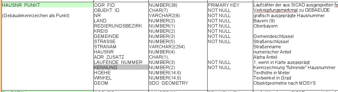
URL: lucasdom.homelinux.org
Port: 1521
DB name: xe
User: gvsig
Password: gvsig

Obviously, it's extremely slow, so we can only play with tiny layers. Let me
know if you have issues with it.

In that DB, the fields of the table MINI_ROAD_4326 are very similar to
Wolfgang's table:

http://listserv.gva.es/pipermail/gvsig_internacional/attachments/20101207/718a9d3d/attachment.jpg

Also, the size of the STRAXLON field is 4000, and if I export it to SHP with
gvSIG 1.10, the resulting fields are like this, according to ogrinfo:

=============================
Geometry: Line String
Feature Count: 95
Extent: (14.762572, 55.029009) - (15.027142, 55.157857)
Layer SRS WKT:
(unknown)
ROWID: String (1.0)
GID: Real (18.0)
OGR_FID: Real (18.0)
OBJ_ID: String (7.0)
NR: String (8.0)
STRANAM: String (254.0)
ADR_ZUS: String (1.0)
LAND: Real (18.0)
REG: Real (18.0)
STRASSE: Real (18.0)
STRAXLON: String (254.0)
STRALON: String (254.0)
HOEHE: Real (18.6)
ADATE: Date (10.0)
=============================

As Wolfgang said, some field types and widths have changed.

After fixing that bug, I get this result, which I think is correct, as far as
the Oracle driver is concerned. Fields of type String are cropped to 254
characters. I'm not sure if this is a limitation of the DBF format or not, but
I have checked that the Oracle driver is providing the metadata correctly:

=============================
Geometry: Line String
Feature Count: 95
Extent: (14.762572, 55.029009) - (15.027142, 55.157857)
Layer SRS WKT:
(unknown)
ROWID: String (1.0)
GID: Real (12.0)
OGR_FID: Real (18.0)
OBJ_ID: String (7.0)
NR: String (8.0)
STRANAM: String (254.0)
ADR_ZUS: String (1.0)
LAND: Integer (2.0)
REG: Integer (1.0)
STRASSE: Integer (5.0)
STRAXLON: String (254.0)
STRALON: String (254.0)
HOEHE: Real (14.6)
ADATE: Date (10.0)
=============================

So Kornel: I have not been able to reproduce your problem. Can you somehow
create a little table (many columns but very few rows) in that DB exactly like
the one that is causing your problems (using SQLDeveloper, gvSIG or other
client)?


Regards,
Juan Lucas Domínguez Rubio
---
Prodevelop SL, Valencia (España)
Tlf.: 96.351.06.12 -- Fax: 96.351.09.68
http://www.prodevelop.es <http://www.prodevelop.es/>
---

________________________________

De: [email protected] en nombre de K.Kiss
Enviado el: mar 14/12/2010 17:00
Para: [email protected]
Asunto: Re: [Gvsig_english] Oracle spatial, field length different after
exporting to shapefile


Hello,

I have a similar problem. Briefly described:
A Oracle View has originally a field of the type Varchar2 with 4000 byte.

If I try into gvSIG (table is loaded and with X/Y - coordinates provide) the
table as Shape to export.
The presentation was ok.
It comes to export errors. 0bytes written

>From the memory (the error-entry): "invalid field type 2 (DBF export)" !
If i shorten the Varchar2 to 255 byte, the problem does not exists....

Greetings
Kornel Kiss

-----
Kornel Kiss

Referat für Gesundheit und Umwelt
Anforderungsmanagement Fachanwendungen
Bayerstr. 28a
80335 München
--
View this message in context:
http://osgeo-org.1803224.n2.nabble.com/Oracle-spatial-field-length-different-after-exporting-to-shapefile-tp5812040p5834434.html
Sent from the gvSIG international mailing list archive at Nabble.com.
_______________________________________________
Gvsig_internacional mailing list
[email protected]
http://listserv.gva.es/cgi-bin/mailman/listinfo/gvsig_internacional
_______________________________________________
Gvsig_internacional mailing list
[email protected]
http://listserv.gva.es/cgi-bin/mailman/listinfo/gvsig_internacional