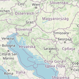
Hello,

I'm rendering a simple map with country borders and labels, and have come up
against a problem with placing labels: they are always placed at the polygon's
center, even if that center is not within the polygon itself. For example, in
[1], the label for Croatia. By contrast, Mapnik tiles for OpenStreetMap[2] seem
to have much better placement. What is going on?
The tile[1] was rendered with the latest Mapnik trunk (mapnik2) with this[3]
configuration file.

Cheers,
-- Alex

[1] http://grep.ro/quickpub/2011-07-27_country-label.png
[2] http://a.tile.openstreetmap.org/5/17/11.png
[3]
https://svn.eionet.europa.eu/repositories/Naaya/trunk/eggs/eea.aoamap/map-data/countries.xml

_______________________________________________
Mapnik-users mailing list
[email protected]
https://lists.berlios.de/mailman/listinfo/mapnik-users