There might have been a bug in the initial implementation. trying it
out with current trunk gives me the expected result, unless I'm
missing something.
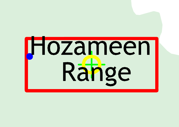
On Sun, Dec 11, 2011 at 20:44, Brent Fraser <[email protected]> wrote:
> Thomas,
>  See comments below.
>
> Best Regards,
> Brent Fraser
>
>
>
> On 12/11/2011 12:26 PM, thomas bonfort wrote:
>>
>> I think this is all expected behavior, although the documentation may
>> be incorrect.
>>
>> LABELPNT draws a marker on the geographic position the label is
>> attached to. This corresponds to the center of the label text only if
>> the label is in position CC.
>
> I think that is what is intended but my original test case (using CC )
> resulted in the LABELPNT rendered on the left side of the labelpoly, see
> http://lists.osgeo.org/pipermail/mapserver-dev/attachments/20110526/47c9bc8c/labelpnt-0001.png.
>   I had expected it to be coincident with the yellow circle and green cross.
>
>
>>
>> To draw a label at the center of the label text, another geomtransform
>> would have to be implemented, named e.g. LABELBBOXCENTROID.
>
> or maybe
>
> GEOMTRANSFORM (centroid([LABELPOLY]))
>
>
>>
>> regards,
>> thomas
>>
>> On Sun, Dec 11, 2011 at 19:34, Brent Fraser<[email protected]>
>>  wrote:
>>>
>>> Hey Jeff,
>>>
>>>  I've been looking into this too (not finished yet).  I'm using v6.0.1
>>> and
>>> can reproduce my original results (blue dot to the left) AND Ian's (grey
>>> dot
>>> coincident with white dot).  Very strange.  My shapefile dataset gets
>>> reprojected from geographic to UTM, so that may be causing the
>>> difference.
>>>  I need to look into that...
>>>
>>> Best Regards,
>>> Brent Fraser
>>>
>>>
>>>
>>> On 12/11/2011 10:57 AM, Jeff McKenna wrote:
>>>>
>>>> On 11-12-11 11:20 AM, Ian Walberg wrote:
>>>>>
>>>>> Here is the map file we are using ms4w 3.0.3.
>>>>>
>>>>> We thought the larger grey circle should be drawn in the center of the
>>>>> label text.
>>>>>
>>>>> What have we done wrong?
>>>>>
>>>>>
>>>> I have done some testing on this on Windows, with MapServer trunk
>>>> (6.1-dev), here are my findings:
>>>>
>>>> - I used Brent's original example styles (from
>>>>
>>>> http://osgeo-org.1803224.n2.nabble.com/GEOMTRANSFORM-labelpnt-location-td6408065.html)
>>>> with Ian's FEATURE layer -->  Brent's "Blue Dot" LABELPNT with POSITION
>>>> CC is
>>>> now correctly placed in the center of the label text (so it seems this
>>>> has
>>>> been fixed in the code, but I can't find the ticket that says that)
>>>> - If I change to POSITION LR (as in Ian's example layer) then I get
>>>> Ian's
>>>> issue (LABELPNT is placed at the geometry location, not in the center of
>>>> the
>>>> label text
>>>> - but this is now an issue of understanding the developer's logic (from
>>>> that thread SteveL says "Let me ponder this and get back to you. I think
>>>> it
>>>> makes sense to use the label point geotransform only with position CC so
>>>> that it matches actual shape location.")
>>>>
>>>> That's all I know at this point (ha pun).
>>>>
>>>> -jeff
>>>>
>>>>
>>>>
>>>>
>>> _______________________________________________
>>> mapserver-users mailing list
>>> [email protected]
>>> http://lists.osgeo.org/mailman/listinfo/mapserver-users
>
>
<<attachment: toto.png>>
![]() labelpnt.map
labelpnt.map
Description: Binary data
_______________________________________________
mapserver-users mailing list
[email protected]
http://lists.osgeo.org/mailman/listinfo/mapserver-users