Hello,

the brilliant osm coastline tool from Jochen Topf
(http://blog.jochentopf.com/2012-04-19-more-coastlines-stuff.html)
enables for creating nice ocean or landcover polygons from
Openstreetmap data.  Well, this is where my mapserver problem
starts...
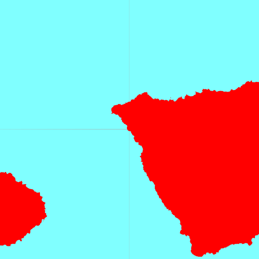
For illustration of the problem I just created ocean polygons around
canary islands

http://home.geggus.net/pub/ocean-canary-islands.zip

They are in sperical mercator using a huge overlap of 30meters to
avoid artifacts.
However artifacts (which seem to depend on scale) still arise:

http://home.geggus.net/pub/ocean.png

Here is the mapfile and shp2img command I used for rendering:

shp2img -o ocean.png -m ocean.map -e -1917656.09 3248262.91 -1839384.59
3326534.41 -s 512 512

MAP

  OUTPUTFORMAT
      NAME agg
      DRIVER AGG/PNG8
      FORMATOPTION "INTERLACE=OFF"
      MIMETYPE "image/png"
  END

  EXTENT         -180 -85 180 85

  IMAGECOLOR 255 0 0

  WEB
      METADATA
        "ows_enable_request" "*"
         wms_srs "EPSG:4326 EPSG:3857"
      END
  END

  PROJECTION
  "init=epsg:3857"
  END

  LAYER
     PROCESSING     "CLOSE_CONNECTION=DEFER"
     NAME           "ocean"
     TYPE           POLYGON
     STATUS         ON
     DATA           "ocean-canary-islands"
     PROJECTION
        "init=epsg:3857"
     END
     CLASS
       STYLE
         COLOR 128 255 255
       END
     END # of class
  END # of layer
END

The only workaround I found so far is to use an outline:

OUTLINECOLOR 128 255 255
WIDTH 1

Is this a bug in mapserver or is there something else which I can do?

Sven

--
"Ich fürchte mich nicht vor der Rückkehr der Faschisten in der Maske der
Faschisten, sondern vor der Rückkehr der Faschisten in der Maske der
Demokraten" (Theodor W. Adorno)
/me is giggls@ircnet, http://sven.gegg.us/ on the Web
_______________________________________________
mapserver-users mailing list
[email protected]
http://lists.osgeo.org/mailman/listinfo/mapserver-users