Hi,

I fear I cannot help with Mapserver configuration. However, I see that you are
using a geographics coordinate system (EPSG:4326) and I would like to ask your
opinion about what  would be the correct distance/length display.
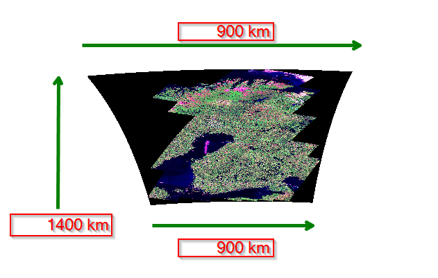
See the screenshot at
http://latuviitta.org/documents/wgs84_distortion_between_60_and_70_degrees_north.png.
 The image area is roughly 15 degrees in both directions. However, as
kilometers the scale is different in South-North direction than in East-West.
In addition, in East-West direction the scale is changing according to the
latitude. The net area of this Landsat image in projected coordinate system
(EPSG:3067) is about 1400 km (height) by 900 km (width) and in that projection
the image is a rectangular box.

With EPSG:4326 a single scale bar using miles as units just cannot work.
Theoretically there could be a two-dimensional scale bar with different scales
for vertical and horizontal distances. The latitude used for computing the
scale could be the center point of the map.  But even then the horizontal scale
would be badly wrong in the extreme North and South if the visible area is
large and far from the equator as in the sample image.

-Jukka Rahkonen-


David Pardy wrote:
Prior to the scalebar, I had set the projection the same per layer:

    PROJECTION
      "proj=longlat"
      "ellps=WGS84"
      "datum=WGS84"
    END

After getting the scalebar to appear, I notice the lengths/distances were not
correct, so I decided to add a map projection outside all the layers. Same as
above.

My scalebar is as follows:

  SCALEBAR
    LABEL
      COLOR 0 0 0
      SIZE SMALL
    END
    STYLE 0
    SIZE 180 8
    POSITION lc
    COLOR 0 0 0
    UNITS MILES
    INTERVALS 2
    TRANSPARENT TRUE
    STATUS EMBED
  END

Any help on the matter would be greatly appreciated.

Thank you.
David
_______________________________________________
mapserver-users mailing list
[email protected]
http://lists.osgeo.org/mailman/listinfo/mapserver-users