Hi list,
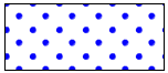
Is the recommended way to create a diagonal point fill such as
http://www.mapserver.org/_images/diagonal-area-symbol.png to use a
pixmap fill? This doesn't allow configuring size and color through STYLEs.
The page at http://www.mapserver.org/mapfile/symbology/construction.html
provides a vector symbol (coords below), but it is long/complex (with a
central circle and a quarter in each corner), and isn't easy to change
spacing between the points. The circle edges are also slightly jagged.
SYMBOL
  NAME "diag_dots"
  TYPE vector
  FILLED true
  POINTS
    # Central circle:
    0.7450    0.4500
    0.7365    0.5147
    0.7115    0.5750
    0.6718    0.6268
    0.6200    0.6665
    0.5597    0.6915
    0.4950    0.7000
    0.4303    0.6915
    0.3700    0.6665
    0.3182    0.6268
    0.2785    0.5750
    0.2535    0.5147
    0.2450    0.4500
    0.2535    0.3853
    0.2785    0.3250
    0.3182    0.2732
    0.3700    0.2335
    0.4303    0.2085
    0.4950    0.2000
    0.5597    0.2085
    0.6200    0.2335
    0.6718    0.2732
    0.7115    0.3250
    0.7365    0.3853
    0.7450    0.4500
    -99 -99
    0.25      0.0
    0.2415    0.0647
    0.2165    0.1250
    0.1768    0.1768
    0.1250    0.2165
    0.0647    0.2415
    0.0       0.25
    0.0       0.0
    0.25      0.0
    -99 -99
    1 0.25
    0.9252    0.2415
    0.8649    0.2165
    0.8132    0.1768
    0.7734    0.1250
    0.7485    0.0647
    0.74      0.0
    1 0.0
    1 0.25
    -99 -99
    0.74      1
    0.7485    0.9252
    0.7734    0.8649
    0.8132    0.8132
    0.8649    0.7734
    0.9252    0.7485
    1 0.74
    1 1
    0.74      1
    -99 -99
    0.0       0.74
    0.0647    0.7485
    0.1250    0.7734
    0.1768    0.8132
    0.2165    0.8649
    0.2415    0.9252
    0.25      1
    0.0       1
    0.0       0.74
  END
END

Regards,

Seth

--
web: http://geographika.co.uk
twitter: @geographika

_______________________________________________
mapserver-users mailing list
mapserver-users@lists.osgeo.org
https://lists.osgeo.org/mailman/listinfo/mapserver-users