Send Users mailing list submissions to
        [email protected]
To subscribe or unsubscribe via the World Wide Web, visit
        http://lists.osgeo.org/mailman/listinfo/openlayers-users
or, via email, send a message with subject or body 'help' to
        [email protected]

You can reach the person managing the list at
        [email protected]

When replying, please edit your Subject line so it is more specific
than "Re: Contents of Users digest..."


Today's Topics:

    1. Re: strange behavior with wrong click event      coordinates and
       drag pan (Puneet Kishor)
    2. OL maps showing tile borders in Chrome (crb)
    3. Re: Introducing mapshup (dr)
    4. Re: Re: Introducing mapshup (jrom)
    5. Re: OL maps showing tile borders in Chrome (Andreas Hocevar)
    6. OL vector/wfs trouble with GeoServer (Neil T)
    7. update text-file-data every call (Jan Tappenbeck)
    8. Re: strange behavior with wrong click event      coordinates and
       drag pan (Puneet Kishor)


----------------------------------------------------------------------

Message: 1
Date: Fri, 6 Jan 2012 11:13:53 -0600
From: Puneet Kishor<[email protected]>
Subject: [OpenLayers-Users] Re: strange behavior with wrong click
        event   coordinates and drag pan
To: [email protected]
Message-ID:<[email protected]>
Content-Type: text/plain; charset=us-ascii

a little more investigation, more revelation (see below)

On Jan 6, 2012, at 10:50 AM, Puneet Kishor wrote:
I am experiencing a strange behavior that perhaps someone can help me
troubleshoot. I am trying to make some custom mods to OpenLayers 2.11 --
nothing fancy, nothing in the JavaScript, only some of the buttons and images.
So, I made a copy of my OL installation, and called it OpenLayers-copy, and
replaced my OL script line in my web page like so

    -<script type="text/javascript"
src="path/to/lib/OpenLayers-2.11/OpenLayers.js"></script>
    +<script type="text/javascript"
src="path/to/lib/OpenLayers-copy/OpenLayers.js"></script>

    var map = new OpenLayers.Map("map", {
        "controls": [
          - new OpenLayers.Control.LayerSwitcher(),
          - new OpenLayers.Control.Navigation(),
          - new OpenLayers.Control.PanZoom(),
          + new OpenLayers.Control.LayerSwitcher({
          +     "roundedCornerColor": "rgba(0,0,0,0.8)"
          + }),
          + new OpenLayers.Control.ZoomPanel(),
            new OpenLayers.Control.MousePosition({
                  "div": document.getElementById("coords"),
                  "numDigits": 2
            })
        ],
        "projection": new OpenLayers.Projection("EPSG:900913"),
        "displayProjection": new OpenLayers.Projection("EPSG:4326"),
        "units": "m",
        "maxResolution": 156543.0339,
        "maxExtent": new OpenLayers.Bounds(-20037508, -20037508, 20037508,
20037508)
    });

    map.events.register("click", map, collections);

    "collections": function(e) {
        var lonlat = map.getLonLatFromViewPortPx(e.xy).transform(
            new OpenLayers.Projection("EPSG:900913"),
            new OpenLayers.Projection("EPSG:4326")
        );

        .. do something with lng/lat ..
    }


That is the extent of my OL changes. I am now seeing the following two
behaviors that are foxing me --

1. The mouse display shows the correct mouse position in lng lat, however, the
actual point clicked on (for further querying is off by several tens of
degrees. For example, if I click at [-78.71, 43.33], the actual point
calculated by the click event listener is [-61.45, 61.61]. Why?
I changed the OL library to the original, as downloaded from OL servers. The
click reported by the mouse position display is off from the click reported by
the map listener even with the original OL library, albeit, by a smaller
amount. For example, I clicked on [-78.35, 43.45] as shown in the mouse
position display. The click event reported [-77.97, 49.61]. A very small lng
shift but a fairly large lat shift.

This is quite perplexing, and definitely very erroneous.
2. I am unable to drag and pan the map. On the other hand, if I bring back
Control.Navigation and Control.PanZoom then I am able to drag pan the map. I
want to be able to drag pan the map, but I don't want to show the PanZoom
controls. How can I achieve that?

Many thanks,


--
Puneet Kishor
------------------------------
Message: 2
Date: Fri, 6 Jan 2012 09:20:30 -0800 (PST)
From: crb<[email protected]>
Subject: [OpenLayers-Users] OL maps showing tile borders in Chrome
To: [email protected]
Message-ID:<[email protected]>
Content-Type: text/plain; charset=us-ascii
Greetings.
I ran across this starting yesterday and was wondering if anyone else has
seen the same or similar...
OL maps are being displayed with white grid lines around map tiles in groups
of 2x3, 3x3 and 4x3 tiles (depending on scale) in Google Chrome only -- at
least the same issue does not exist in FireFox or IE. It looks like Chrome
was updated to v16.0.912.75 yesterday at 15:00 EST, but this issue occurred
earlier in the day than that for me (also occurred on v16.0.912.63). It
occurs for Bing base maps, Google, etc. and does not occur in Chrome when
hitting maps.google.com or www.bing.com/maps directly. My map was created
w/ default options, i.e. a simple "var map = new OpenLayers.Map('map');" and
then added Bing/Google layers.
http://osgeo-org.1803224.n2.nabble.com/file/n7159120/olmap_grid.png
Has anyone else experienced this?
--
View this message in context:
http://osgeo-org.1803224.n2.nabble.com/OL-maps-showing-tile-borders-in-Chrome-tp7159120p7159120.html
Sent from the OpenLayers Users mailing list archive at Nabble.com.
------------------------------
Message: 3
Date: Fri, 6 Jan 2012 09:23:14 -0800 (PST)
From: dr<[email protected]>
Subject: [OpenLayers-Users] Re: Introducing mapshup
To: [email protected]
Message-ID:<[email protected]>
Content-Type: text/plain; charset=us-ascii
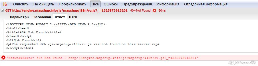
Hi.
Big thanks for application! But my colleague reported me application not
works. See screenshot:
http://gis-lab.info/images/screenshots/20120106-2bn-42kb.jpg
-----
Denis Rykov
NextGIS
http://www.nextgis.org/
--
View this message in context:
http://osgeo-org.1803224.n2.nabble.com/Introducing-mapshup-tp7158339p7159131.html
Sent from the OpenLayers Users mailing list archive at Nabble.com.
------------------------------
Message: 4
Date: Fri, 6 Jan 2012 19:11:13 +0100
From: jrom<[email protected]>
Subject: Re: [OpenLayers-Users] Re: Introducing mapshup
To: dr<[email protected]>
Cc: [email protected]
Message-ID:
<calp+wc_pvmgf5q5jesq1jbhwawwcsa8w9aerojzoowiunya...@mail.gmail.com>
Content-Type: text/plain; charset=ISO-8859-1
Hi Denis,
Thank you for your feedback. Application automatically detects the
browser lang. I completely forget to put the russian translation on
the server that's why your friend get an error. It's corrected now
(everything should be displayed in english).
Regards
Jerome
2012/1/6 dr<[email protected]>:
Hi.

Big thanks for application! But my colleague reported me application not
works. See screenshot:
http://gis-lab.info/images/screenshots/20120106-2bn-42kb.jpg

-----
Denis Rykov
NextGIS
http://www.nextgis.org/
--
View this message in context:
http://osgeo-org.1803224.n2.nabble.com/Introducing-mapshup-tp7158339p7159131.html
Sent from the OpenLayers Users mailing list archive at Nabble.com.
_______________________________________________
Users mailing list
[email protected]
http://lists.osgeo.org/mailman/listinfo/openlayers-users