Hi

I also think there is no point in maintaining two iconsets - lets
rather use the good feedback in this thread to make Roberts icon set
awesome.
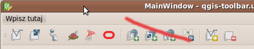
@Robert - what about using a background colour scheme whereby e.g. all
add layer icons get the same background colour and then you can remove
e.g. the + and layer picture elements as they are visually grouped.
Just a thought anyway....

Regards

Tim

On Fri, May 24, 2013 at 10:51 PM, Robert Szczepanek
<[email protected]> wrote:
> Layer toolbar could look like this [1], except OWS icons.
> Oracle Spatial logo was not found, so I took 'O' from Oracle, but it looks
> ugly in this context. Combination of this 'O' with database symbol doesn't
> look nice either. Some proposals ...?
>
> We could leave old database symbol with different colours, but MSSQL,
> SpatiaLite and Oracle icons are mainly red so this will be hard.
> Additionally we must remember about color-blind persons.
>
> regards,
> Robert
>
> [1] http://robert.szczepanek.pl/tmp/layer-toolbar.png
>
>
> On 24.05.2013 13:51, Robert Szczepanek wrote:
>>
>> Hi Jonathan,
>>
>> You are right. Problem with new icons is that we have started with some
>> idea (add raster, vector, PostgreSQL layer) and end up with several
>> icons of the same type. First three icons are different, however have
>> too many elements. Next are worse, and Oracle and others wait for more
>> general problem solution.
>>
>> What are the options from my point of view (just layer toolbar)?
>>
>> 1. We could remove green plus leaving the others (yellow star and red
>> minus). This will give some more space to increase symbol size.
>>
>> 2. Remove 'layer' symbol, but in this case 'create vector layer' will be
>> identical to 'create vector' in edit toolbar. But considering toolbar
>> context is could be OK.
>> Definitely we should remove 'layer' from WMS, WFS and similar.
>>
>> 3. Due to variety of database formats replace them with clones of
>> database logo.
>>
>> All changes are possible, but after general agreement. We can do it now
>> or after QGIS 2.0 release.
>>
>> regards,
>> Robert
>>
>> On 24.05.2013 10:59, Jonathan Moules wrote:
>>>
>>> +1
>>>
>>> i.e. The difference between the "Add PostGIS layers" and "Add SpatiaLite
>>> layers" is that one has a regular cylinder and the other has a
>>> fat-waisted hour-glass cylinder - about 20-30 pixels are different in an
>>> icon that's got 1024 pixels! I have to look at them in detail to see the
>>> differences. And there's still MSSQL and Oracle icons to be created in
>>> the new schema which using this system will only confuse things more.
>>>
>>>
>>> Don't get me wrong, I like the style of the new icons, but they're
>>> really hard to visually differentiate.
>>>
>>>
>>> I did a quick google and came across this:
>>>
>>> http://turbomilk.com/blog/cookbook/icon_design/10_mistakes_in_icon_design/
>>>
>>>
>>> The QGIS icons do all of the top three things.
>>>
>>> Jonathan
>>>
>>>
>>>
>>>
>>>
>>> On 24 May 2013 09:27, skampus <[email protected]
>>> <mailto:[email protected]>> wrote:
>>>
>>>     that could be a useful option.
>>>     sincerely, from my point of view, many icons are
>>>     unreadable/undistinguishable so i click them correctly only because
>>>     now i
>>>     remberer relative position
>>>
>>>
>>>
>>>
>>>     --
>>>     View this message in context:
>>>
>>>
>>> http://osgeo-org.1560.x6.nabble.com/Re-Qgis-user-New-Icons-difficult-to-read-tp5055427p5055467.html
>>>
>>>     Sent from the Quantum GIS - Developer mailing list archive at
>>>     Nabble.com.
>>>     _______________________________________________
>>>     Qgis-developer mailing list
>>>     [email protected]
>>> <mailto:[email protected]>
>>>     http://lists.osgeo.org/mailman/listinfo/qgis-developer
>>>
>>>
>>>
>>> This transmission is intended for the named addressee(s) only and may
>>> contain sensitive or protectively marked material up to RESTRICTED and
>>> should be handled accordingly. Unless you are the named addressee (or
>>> authorised to receive it for the addressee) you may not copy or use it,
>>> or disclose it to anyone else. If you have received this transmission in
>>> error please notify the sender immediately. All email traffic sent to or
>>> from us, including without limitation all GCSX traffic, may be subject
>>> to recording and/or monitoring in accordance with relevant legislation.
>>>
>>>
>>> _______________________________________________
>>> Qgis-developer mailing list
>>> [email protected]
>>> http://lists.osgeo.org/mailman/listinfo/qgis-developer
>>>
>>
>> _______________________________________________
>> Qgis-developer mailing list
>> [email protected]
>> http://lists.osgeo.org/mailman/listinfo/qgis-developer
>>
>
> _______________________________________________
> Qgis-developer mailing list
> [email protected]
> http://lists.osgeo.org/mailman/listinfo/qgis-developer


--
Tim Sutton - QGIS Project Steering Committee Member (Release  Manager)
==============================================
Please do not email me off-list with technical
support questions. Using the lists will gain
more exposure for your issues and the knowledge
surrounding your issue will be shared with all.

Visit http://linfiniti.com to find out about:
 * QGIS programming and support services
 * Mapserver and PostGIS based hosting plans
 * FOSS Consulting Services
Skype: timlinux
Irc: timlinux on #qgis at freenode.net
==============================================
_______________________________________________
Qgis-developer mailing list
[email protected]
http://lists.osgeo.org/mailman/listinfo/qgis-developer