Wow, thank you very much Even! I think this solution is just fine!

Thanks again!
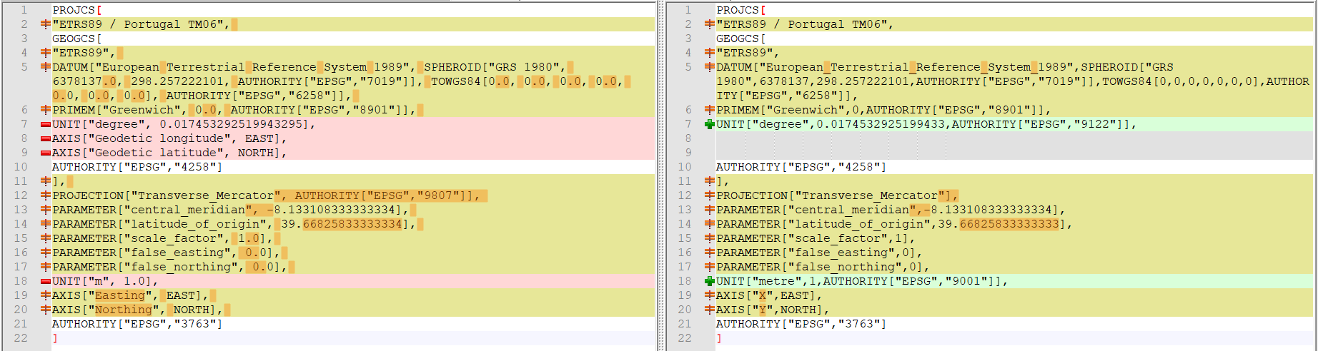
Best regards,
Pedro


A sábado, 27/11/2021, 19:38, Even Rouault <[email protected]>
escreveu:

> Petro,
>
> I've queued https://github.com/OSGeo/gdal/pull/4908 which will "fix" that
> particular case (more precisely anything based on ETRS89). I'm not super
> satisfied with this, and I believe there's no miracle solution for all
> potential use cases. What GDAL returns in both 2.4.0 and 3.4.0 is actually
> pretty much the same object, despite the different representation (WKT1 vs
> WKT2). The root cause of the issue is with the TOWGS84[] node. Those nodes
> are not part of CRS definitions. They date back to the time where the GDAL
> & PROJ stack wasn't capable of more powerful transformation, and so a
> particular datum transformation to WGS 84 was picked up, and encoded in the
> CRS definition. When reading such definitions nowadays, we have a dilemna:
> did the user really meant to use the particular transformation that was in
> TOWGS84[], or was it just there because that was the default one. We ere on
> the side of caution (most of time, there are a few exceptions there and
> there in GDAL), and keep the transformation information, which makes that
> this CRS is formally not the official definition, and thus considered as
> ""custom""
>
> However, for ETRS89, I believe we can safely remove it, since as far as I
> know, there's no better transformation between ETRS89 (which is known
> modeled as a "datum ensemble" by EPSG, meaning any of the 11 ETRF
> realizations) and WGS 84 (itself a datum ensemble) than the
> TOWGS84[0.0,0.0,0.0,0.0,0.0,0.0,0.0], and it is unlikely there will be an
> alternative one in the future, given the dynamic nature of the WGS 84 datum
> (maybe I'm speaking too fast. When ETRS89 and WGS 84 coordinates will have
> drifted too far away in the future, maybe there will some non-null
> transformation added in the database, so that users who want to transform
> to a 'past' or 'future' coordinate epoch of WGS 84 can do that in a not too
> bad way.)
>
> (I should not that this .prj file isn't really compliant with the Esri
> dialect of WKT, which is supposed to be used for shapefiles, since normally
> it shouldn't contain TOWGS84 or AUHTORITY code)
>
> Even
>
>
> Le 27/11/2021 à 19:13, Pedro Venâncio a écrit :
>
> Hi all,
>
> I'm seeing that QGIS 3.16 / 3.22 does not recognize the CRS of specific
> layers generated by GeoServer, but the old QGIS 2.18.28 recognize.
>
> For instance, this shapefile: https://si.icnf.pt/shp/rnap
>
> Checking ogrinfo in different versions:
>
> ogrinfo --version
> GDAL 2.4.0, released 2018/12/14 (Used by QGIS 2.18.28)
>
> ogrinfo -al rnap.shp
> INFO: Open of `rnap.shp'
>       using driver `ESRI Shapefile' successful.
>
> Layer name: rnap
> Metadata:
>   DBF_DATE_LAST_UPDATE=1921-11-27
> Geometry: Polygon
> Feature Count: 48
> Extent: (-123561.201500, -300415.400000) - (162054.118700, 268136.980100)
> Layer SRS WKT:
> PROJCS["ETRS89 / Portugal TM06",
>     GEOGCS["ETRS89",
>         DATUM["European Terrestrial Reference System 1989",
>             SPHEROID["GRS 1980",6378137.0,298.257222101,
>                 AUTHORITY["EPSG","7019"]],
>             TOWGS84[0.0,0.0,0.0,0.0,0.0,0.0,0.0],
>             AUTHORITY["EPSG","6258"]],
>         PRIMEM["Greenwich",0.0,
>             AUTHORITY["EPSG","8901"]],
>         UNIT["degree",0.017453292519943295],
>         AXIS["Geodetic longitude",EAST],
>         AXIS["Geodetic latitude",NORTH],
>         AUTHORITY["EPSG","4258"]],
>     PROJECTION["Transverse_Mercator",
>         AUTHORITY["EPSG","9807"]],
>     PARAMETER["central_meridian",-8.133108333333334],
>     PARAMETER["latitude_of_origin",39.66825833333334],
>     PARAMETER["scale_factor",1.0],
>     PARAMETER["false_easting",0.0],
>     PARAMETER["false_northing",0.0],
>     UNIT["m",1.0],
>     AXIS["Easting",EAST],
>     AXIS["Northing",NORTH],
>     AUTHORITY["EPSG","3763"]]
> nome_ap: String (254.0)
> classifica: String (254.0)
> publica1: String (254.0)
> publica2: String (254.0)
> jurisdicao: String (254.0)
> area_ha: Real (33.15)
> sigla: String (254.0)
>
>
>
> ogrinfo --version
> GDAL 3.4.0, released 2021/11/04 (Used by QGIS 3.22)
>
> ogrinfo -al rnap.shp
> INFO: Open of `rnap.shp'
>       using driver `ESRI Shapefile' successful.
>
> Layer name: rnap
> Metadata:
>   DBF_DATE_LAST_UPDATE=1920-08-17
> Geometry: Polygon
> Feature Count: 48
> Extent: (-123561.201500, -300415.400000) - (162054.118700, 268136.980100)
> Layer SRS WKT:
> BOUNDCRS[
>     SOURCECRS[
>         PROJCRS["ETRS89 / Portugal TM06",
>             BASEGEOGCRS["ETRS89",
>                 ENSEMBLE["European Terrestrial Reference System 1989
> ensemble",
>                     MEMBER["European Terrestrial Reference Frame 1989"],
>                     MEMBER["European Terrestrial Reference Frame 1990"],
>                     MEMBER["European Terrestrial Reference Frame 1991"],
>                     MEMBER["European Terrestrial Reference Frame 1992"],
>                     MEMBER["European Terrestrial Reference Frame 1993"],
>                     MEMBER["European Terrestrial Reference Frame 1994"],
>                     MEMBER["European Terrestrial Reference Frame 1996"],
>                     MEMBER["European Terrestrial Reference Frame 1997"],
>                     MEMBER["European Terrestrial Reference Frame 2000"],
>                     MEMBER["European Terrestrial Reference Frame 2005"],
>                     MEMBER["European Terrestrial Reference Frame 2014"],
>                     ELLIPSOID["GRS 1980",6378137,298.257222101,
>                         LENGTHUNIT["metre",1]],
>                     ENSEMBLEACCURACY[0.1]],
>                 PRIMEM["Greenwich",0,
>                     ANGLEUNIT["degree",0.0174532925199433]],
>                 ID["EPSG",4258]],
>             CONVERSION["Portugual TM06",
>                 METHOD["Transverse Mercator",
>                     ID["EPSG",9807]],
>                 PARAMETER["Latitude of natural origin",39.6682583333333,
>                     ANGLEUNIT["degree",0.0174532925199433],
>                     ID["EPSG",8801]],
>                 PARAMETER["Longitude of natural origin",-8.13310833333333,
>                     ANGLEUNIT["degree",0.0174532925199433],
>                     ID["EPSG",8802]],
>                 PARAMETER["Scale factor at natural origin",1,
>                     SCALEUNIT["unity",1],
>                     ID["EPSG",8805]],
>                 PARAMETER["False easting",0,
>                     LENGTHUNIT["metre",1],
>                     ID["EPSG",8806]],
>                 PARAMETER["False northing",0,
>                     LENGTHUNIT["metre",1],
>                     ID["EPSG",8807]]],
>             CS[Cartesian,2],
>                 AXIS["easting (X)",east,
>                     ORDER[1],
>                     LENGTHUNIT["metre",1]],
>                 AXIS["northing (Y)",north,
>                     ORDER[2],
>                     LENGTHUNIT["metre",1]],
>             USAGE[
>                 SCOPE["Topographic mapping (medium scale)."],
>                 AREA["Portugal - mainland - onshore."],
>                 BBOX[36.95,-9.56,42.16,-6.19]],
>             ID["EPSG",3763]]],
>     TARGETCRS[
>         GEOGCRS["WGS 84",
>             DATUM["World Geodetic System 1984",
>                 ELLIPSOID["WGS 84",6378137,298.257223563,
>                     LENGTHUNIT["metre",1]]],
>             PRIMEM["Greenwich",0,
>                 ANGLEUNIT["degree",0.0174532925199433]],
>             CS[ellipsoidal,2],
>                 AXIS["latitude",north,
>                     ORDER[1],
>                     ANGLEUNIT["degree",0.0174532925199433]],
>                 AXIS["longitude",east,
>                     ORDER[2],
>                     ANGLEUNIT["degree",0.0174532925199433]],
>             ID["EPSG",4326]]],
>     ABRIDGEDTRANSFORMATION["ETRS89 to WGS 84 (1)",
>         VERSION["EPSG-eur"],
>         METHOD["Geocentric translations (geog2D domain)",
>             ID["EPSG",9603]],
>         PARAMETER["X-axis translation",0,
>             ID["EPSG",8605]],
>         PARAMETER["Y-axis translation",0,
>             ID["EPSG",8606]],
>         PARAMETER["Z-axis translation",0,
>             ID["EPSG",8607]],
>         USAGE[
>             SCOPE["(null/copy) Approximation for medium and low accuracy
> applications assuming equality between plate-fixed static and earth-fixed
> dynamic CRSs, ignoring static/dynamic CRS differences."],
>             AREA["Europe - onshore and offshore: Albania; Andorra;
> Austria; Belgium; Bosnia and Herzegovina; Bulgaria; Croatia; Cyprus;
> Czechia; Denmark; Estonia; Faroe Islands; Finland; France; Germany;
> Gibraltar; Greece; Hungary; Ireland; Italy; Kosovo; Latvia; Liechtenstein;
> Lithuania; Luxembourg; Malta; Moldova; Monaco; Montenegro; Netherlands;
> North Macedonia; Norway including Svalbard and Jan Mayen; Poland; Portugal;
> Romania; San Marino; Serbia; Slovakia; Slovenia; Spain; Sweden;
> Switzerland; United Kingdom (UK) including Channel Islands and Isle of Man;
> Vatican City State."],
>             BBOX[32.88,-16.1,84.73,40.18]],
>         ID["EPSG",1149],
>         REMARK["ETRS89 and WGS 84 are realizations of ITRS coincident to
> within 1 metre. This transformation has an accuracy equal to the
> coincidence figure."]]]
> Data axis to CRS axis mapping: 1,2
> nome_ap: String (254.0)
> classifica: String (254.0)
> publica1: String (254.0)
> publica2: String (254.0)
> jurisdicao: String (254.0)
> area_ha: Real (33.15)
> sigla: String (254.0)
>
> The differences between rnap.prj (left) and https://epsg.io/3763 (right)
> are few:
>
>
> https://cld.pt/dl/download/5d9b5324-b28a-4654-a8f7-365c7cc39c10/rnap_prj.png
>
> The GeoServer version that is generating this layer is old.
>
> So, could this be a bug?
>
> Thanks!
>
> Best regards,
> Pedro
>
> _______________________________________________
> QGIS-Developer mailing [email protected]
> List info: https://lists.osgeo.org/mailman/listinfo/qgis-developer
> Unsubscribe: https://lists.osgeo.org/mailman/listinfo/qgis-developer
>
> -- http://www.spatialys.com
> My software is free, but my time generally not.
>
> _______________________________________________
> QGIS-Developer mailing list
> [email protected]
> List info: https://lists.osgeo.org/mailman/listinfo/qgis-developer
> Unsubscribe: https://lists.osgeo.org/mailman/listinfo/qgis-developer
>
_______________________________________________
QGIS-Developer mailing list
[email protected]
List info: https://lists.osgeo.org/mailman/listinfo/qgis-developer
Unsubscribe: https://lists.osgeo.org/mailman/listinfo/qgis-developer