Bonjour (ça ne fait jamais de mal)
Vous recevez ces mails parce que vous vous êtes inscrit à cette liste!
Nul autre ne l'a fait pour vous.
Maintenant, pour vous désinscrire, la procédure est juste en dessous de
votre mail, dans ce fil de discussion.
Géomatiquement,

Harrissou

Le 13/06/2021 à 15:40, LEVIS CHIAKTO a écrit :
Arrêtez de m'envoyer vos mails
Le dim. 13 juin 2021 à 00:29, <[email protected]
<mailto:[email protected]>> a écrit :
Send Qgis-user mailing list submissions to
[email protected] <mailto:[email protected]>
To subscribe or unsubscribe via the World Wide Web, visit
https://lists.osgeo.org/mailman/listinfo/qgis-user
<https://lists.osgeo.org/mailman/listinfo/qgis-user>
or, via email, send a message with subject or body 'help' to
[email protected]
<mailto:[email protected]>
You can reach the person managing the list at
[email protected]
<mailto:[email protected]>
When replying, please edit your Subject line so it is more specific
than "Re: Contents of Qgis-user digest..."
Today's Topics:
1. Snapping adjoining existing polygons (Pat Brown)
2. Re: Snapping adjoining existing polygons (David Strip)
----------------------------------------------------------------------
Message: 1
Date: Sun, 13 Jun 2021 00:20:09 +0200
From: Pat Brown <[email protected] <mailto:[email protected]>>
To: QGIS Mailing List <[email protected]
<mailto:[email protected]>>
Subject: [Qgis-user] Snapping adjoining existing polygons
Message-ID:
<CAJdnw=jbfds1vtqgbothxr-qjor-rfuxfaopwzoh7rbr3vn...@mail.gmail.com
<mailto:[email protected]>>
Content-Type: text/plain; charset="utf-8"
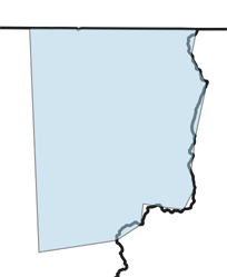
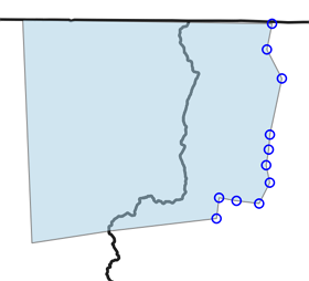
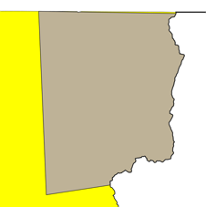
I have 2 shape files. One, which has been accurately digitised,
contains
provinces. The second one, which has been badly digitised,
contains regions
within the provinces. I now need to edit the regions so that their
boundaries snap to the boundaries of the provinces where they are
adjacent.
I think something like snap and trace should work but I cannot
figure out
how to do this. Can anyone please advise?
-------------- next part --------------
An HTML attachment was scrubbed...
URL:
<http://lists.osgeo.org/pipermail/qgis-user/attachments/20210613/af827f54/attachment-0001.html
<http://lists.osgeo.org/pipermail/qgis-user/attachments/20210613/af827f54/attachment-0001.html>>
------------------------------
Message: 2
Date: Sat, 12 Jun 2021 17:23:22 -0600
From: David Strip <[email protected]
<mailto:[email protected]>>
To: Pat Brown <[email protected]
<mailto:[email protected]>>, QGIS Mailing List
<[email protected] <mailto:[email protected]>>
Subject: Re: [Qgis-user] Snapping adjoining existing polygons
Message-ID: <[email protected]
<mailto:[email protected]>>
Content-Type: text/plain; charset="us-ascii"
An HTML attachment was scrubbed...
URL:
<http://lists.osgeo.org/pipermail/qgis-user/attachments/20210612/f8d254a6/attachment.html
<http://lists.osgeo.org/pipermail/qgis-user/attachments/20210612/f8d254a6/attachment.html>>
-------------- next part --------------
A non-text attachment was scrubbed...
Name: gbngckdnghneobil.png
Type: image/png
Size: 12524 bytes
Desc: not available
URL:
<http://lists.osgeo.org/pipermail/qgis-user/attachments/20210612/f8d254a6/attachment.png
<http://lists.osgeo.org/pipermail/qgis-user/attachments/20210612/f8d254a6/attachment.png>>
-------------- next part --------------
A non-text attachment was scrubbed...
Name: ndhjaocficigdbbg.png
Type: image/png
Size: 18869 bytes
Desc: not available
URL:
<http://lists.osgeo.org/pipermail/qgis-user/attachments/20210612/f8d254a6/attachment-0001.png
<http://lists.osgeo.org/pipermail/qgis-user/attachments/20210612/f8d254a6/attachment-0001.png>>
-------------- next part --------------
A non-text attachment was scrubbed...
Name: iieajdnhgaifapah.png
Type: image/png
Size: 9621 bytes
Desc: not available
URL:
<http://lists.osgeo.org/pipermail/qgis-user/attachments/20210612/f8d254a6/attachment-0002.png
<http://lists.osgeo.org/pipermail/qgis-user/attachments/20210612/f8d254a6/attachment-0002.png>>
------------------------------
Subject: Digest Footer
_______________________________________________
Qgis-user mailing list
[email protected] <mailto:[email protected]>
List info: https://lists.osgeo.org/mailman/listinfo/qgis-user
<https://lists.osgeo.org/mailman/listinfo/qgis-user>
Unsubscribe: https://lists.osgeo.org/mailman/listinfo/qgis-user
<https://lists.osgeo.org/mailman/listinfo/qgis-user>
------------------------------
End of Qgis-user Digest, Vol 184, Issue 29
******************************************
_______________________________________________
Qgis-user mailing list
[email protected]
List info: https://lists.osgeo.org/mailman/listinfo/qgis-user
Unsubscribe: https://lists.osgeo.org/mailman/listinfo/qgis-user
_______________________________________________
Qgis-user mailing list
[email protected]
List info: https://lists.osgeo.org/mailman/listinfo/qgis-user
Unsubscribe: https://lists.osgeo.org/mailman/listinfo/qgis-user