Hello Chris,

The data is in WGS84 UTM- zone 19S (EPSG: 32719),
and I got the geometries (perimeter and area) in meter units,
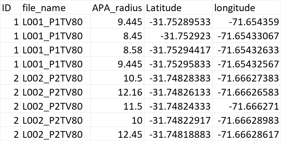
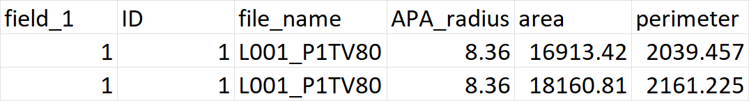
Thanks,
Carol.


[cid:a0cc4647-a916-4598-9804-e66d1d0ff7a1]<https://outlook.office.com/bookwithme/user/[email protected]?anonymous&ep=bwmEmailSignature>
          Book time to meet with
me<https://outlook.office.com/bookwithme/user/[email protected]?anonymous&ep=bwmEmailSignature>
________________________________
From: QGIS-User <[email protected]> on behalf of
[email protected] <[email protected]>
Sent: December 29, 2024 9:48 PM
To: [email protected] <[email protected]>
Subject: QGIS-User Digest, Vol 226, Issue 27

Send QGIS-User mailing list submissions to
        [email protected]

To subscribe or unsubscribe via the World Wide Web, visit
        https://lists.osgeo.org/mailman/listinfo/qgis-user
or, via email, send a message with subject or body 'help' to
        [email protected]

You can reach the person managing the list at
        [email protected]

When replying, please edit your Subject line so it is more specific
than "Re: Contents of QGIS-User digest..."


Today's Topics:

   1. Re: Help with Buffer and Category-Specific Geometry Outputs
      in QGIS (chris hermansen)


----------------------------------------------------------------------

Message: 1
Date: Sun, 29 Dec 2024 21:48:31 -0800
From: chris hermansen <[email protected]>
To: Carolina Lang <[email protected]>
Cc: qgis-user <[email protected]>
Subject: Re: [Qgis-user] Help with Buffer and Category-Specific
        Geometry Outputs in QGIS
Message-ID:
        <CACc2_6-6QNyyyOhoovwd_=X1vZfMhZhbpjT-X+sd+K9iJZ=0...@mail.gmail.com>
Content-Type: text/plain; charset="utf-8"

Carolina and list,

On Sun, Dec 29, 2024, 21:39 Carolina Lang via QGIS-User <
[email protected]> wrote:

> Hello everyone,
> I'm using QGIS 3.34 and working with the vector-geometry-buffer function
> on a shapefile containing multiple spatial points, categories (or location
> type) are represented as a group of these spatial points. For each
> category, my goal is to calculate the geometries (perimeter and area)
> created by the buffers.
> While the output result includes these geometries, it does not properly
> associate them with their respective categories. Instead, for each row in
> the output, I see the same category listed but with varying perimeters and
> areas, making it difficult to distinguish which geometries belong to which
> category.
> Example
> input file_(here I use column APA_radius as variable distances for buffer)
> output file_9as you can see geometries for both categories but no idea
> which geometries belong to which category)
> Has anyone encountered this issue before? Is there a specific step or
> method I might be missing to properly link the geometries to their
> respective categories?
>

What is your projection for your shape file?

If it's not projected ie in lat-lon your buffer radius won't be interpreted
as metres.

Chris

>
-------------- next part --------------
An HTML attachment was scrubbed...
URL:
<http://lists.osgeo.org/pipermail/qgis-user/attachments/20241229/79809b61/attachment.htm>
-------------- next part --------------
A non-text attachment was scrubbed...
Name: image.png
Type: image/png
Size: 59928 bytes
Desc: not available
URL:
<http://lists.osgeo.org/pipermail/qgis-user/attachments/20241229/79809b61/attachment.png>
-------------- next part --------------
A non-text attachment was scrubbed...
Name: image.png
Type: image/png
Size: 17861 bytes
Desc: not available
URL:
<http://lists.osgeo.org/pipermail/qgis-user/attachments/20241229/79809b61/attachment-0001.png>

------------------------------

Subject: Digest Footer

_______________________________________________
QGIS-User mailing list
[email protected]
List info: https://lists.osgeo.org/mailman/listinfo/qgis-user
Unsubscribe: https://lists.osgeo.org/mailman/listinfo/qgis-user


------------------------------

End of QGIS-User Digest, Vol 226, Issue 27
******************************************
_______________________________________________
QGIS-User mailing list
[email protected]
List info: https://lists.osgeo.org/mailman/listinfo/qgis-user
Unsubscribe: https://lists.osgeo.org/mailman/listinfo/qgis-user