Hi all,
I'm serving a Geotiff through a standard Geotiff source image warehouse.here
the gdalinfo output :
Driver: GTiff/GeoTIFFFiles: example.tifSize is 12420, 9986Coordinate System
is:PROJCS["NTF (Paris) / Lambert zone II", GEOGCS["NTF (Paris)",
DATUM["Nouvelle_Triangulation_Francaise_Paris", SPHEROID["Clarke
1880 (IGN)",6378249.2,293.4660212936269,
AUTHORITY["EPSG","7011"]], TOWGS84[-168,-60,320,0,0,0,0],
AUTHORITY["EPSG","6807"]], PRIMEM["Paris",2.33722917,
AUTHORITY["EPSG","8903"]], UNIT["grad",0.01570796326794897,
AUTHORITY["EPSG","9105"]], AUTHORITY["EPSG","4807"]],
PROJECTION["Lambert_Conformal_Conic_1SP"],
PARAMETER["latitude_of_origin",52], PARAMETER["central_meridian",0],
PARAMETER["scale_factor",0.99987742], PARAMETER["false_easting",600000],
PARAMETER["false_northing",2200000], UNIT["metre",1,
AUTHORITY["EPSG","9001"]], AXIS["X",EAST], AXIS["Y",NORTH],
AUTHORITY["EPSG","27572"]]Origin =
(534892.311252549290657,2471690.869099652394652)Pixel Size =
(12.500000000000000,-12.500000000000000)Metadata: AREA_OR_POINT=AreaImage
Structure Metadata: INTERLEAVE=BANDCorner Coordinates:Upper Left (
534892.311, 2471690.869) ( 0d59'33.42"W, 54d42'38.80"N)Lower Left (
534892.311, 2346865.869) ( 0d58'17.21"W, 53d27'51.07"N)Upper Right (
690142.311, 2471690.869) ( 1d22'27.24"E, 54d42'26.60"N)Lower Right (
690142.311, 2346865.869) ( 1d20'41.75"E, 53d27'39.13"N)Center (
612517.311, 2409278.369) ( 0d11'19.63"E, 54d 5'28.09"N)Band 1 Block=12420x1
Type=Float64, ColorInterp=Gray NoData Value=-9999 Overviews: 6210x4993,
3105x2497, 2070x1665, 1553x1249, 777x625, 389x313, 195x157, 98x79, 50x40
I built overviews with the gauss downsampling algorithm (and i have tried the
others but the issue is more or less the same)
My image is served as a WMS tile layer through a basic Open Layers (4) app, and
the styling is made from sld ColorMaps entries.
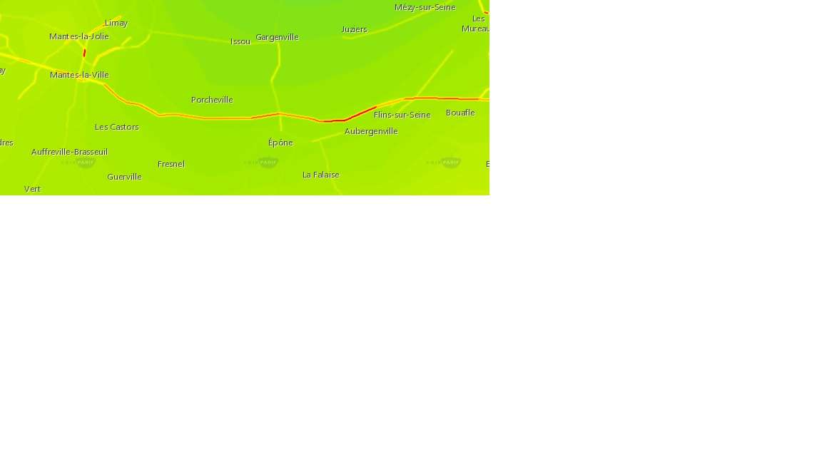
Here is the problem : when zoomed in, some roads look like that (red colored,
which is normal styling) :
http://imageshack.com/a/img922/7479/Mpxrwg.jpg
when zoomed out, they are downsampled  and look like that (something like
yellow which is used for lower values in my styling) :

https://imageshack.com/i/pmFccqDnj

My aim is to keep the "red" aspect of these roads no matter the zoom levels.
I tried to switch the different WMS interpolation methods without any success.
I hope to find a solution if there's any !
Thanks,Emeric
------------------------------------------------------------------------------
Check out the vibrant tech community on one of the world's most
engaging tech sites, Slashdot.org! http://sdm.link/slashdot
_______________________________________________
Geoserver-users mailing list

Please make sure you read the following two resources before posting to this
list:
- Earning your support instead of buying it, but Ian Turton:
http://www.ianturton.com/talks/foss4g.html#/
- The GeoServer user list posting guidelines:
http://geoserver.org/comm/userlist-guidelines.html

Geoserver-users@lists.sourceforge.net
https://lists.sourceforge.net/lists/listinfo/geoserver-users