This is an automated email from the git hooks/post-receive script.

johanvdw-guest pushed a commit to branch master
in repository python-descartes.
commit 1ddbda5916f7dcacaaafcd5a259be693951788be
Author: Johan Van de Wauw <johan.vandew...@gmail.com>
Date: Thu Dec 18 07:19:52 2014 +0100
Imported Upstream version 1.0.1
---
PKG-INFO | 85 +++++++++++++++++++++++++++++++++
README.txt | 65 +++++++++++++++++++++++++
descartes.egg-info/PKG-INFO | 85 +++++++++++++++++++++++++++++++++
descartes.egg-info/SOURCES.txt | 11 +++++
descartes.egg-info/dependency_links.txt | 1 +
descartes.egg-info/not-zip-safe | 1 +
descartes.egg-info/top_level.txt | 1 +
descartes/__init__.py | 4 ++
descartes/patch.py | 66 +++++++++++++++++++++++++
descartes/tests.py | 38 +++++++++++++++
setup.cfg | 5 ++
setup.py | 33 +++++++++++++
12 files changed, 395 insertions(+)
diff --git a/PKG-INFO b/PKG-INFO
new file mode 100644
index 0000000..c1ca2fd
--- /dev/null
+++ b/PKG-INFO
@@ -0,0 +1,85 @@
+Metadata-Version: 1.1
+Name: descartes
+Version: 1.0.1
+Summary: Use geometric objects as matplotlib paths and patches
+Home-page: http://bitbucket.org/sgillies/descartes/
+Author: Sean Gillies
+Author-email: sean.gill...@gmail.com
+License: BSD
+Description: Descartes
+ =========
+
+ Use Shapely_ or GeoJSON-like geometric objects as matplotlib paths and
patches
+
+ .. image::
http://farm4.static.flickr.com/3662/4555372019_9bbed1f956_o_d.png
+ :width: 800
+ :height: 320
+
+ Requires: matplotlib, numpy, and optionally Shapely 1.2+.
+
+ Example::
+
+ from matplotlib import pyplot
+ from shapely.geometry import LineString
+ from descartes import PolygonPatch
+
+ BLUE = '#6699cc'
+ GRAY = '#999999'
+
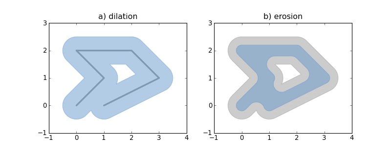
+ def plot_line(ax, ob):
+ x, y = ob.xy
+ ax.plot(x, y, color=GRAY, linewidth=3, solid_capstyle='round',
zorder=1)
+
+ line = LineString([(0, 0), (1, 1), (0, 2), (2, 2), (3, 1), (1, 0)])
+
+ fig = pyplot.figure(1, figsize=(10, 4), dpi=180)
+
+ # 1
+ ax = fig.add_subplot(121)
+
+ plot_line(ax, line)
+
+ dilated = line.buffer(0.5)
+ patch1 = PolygonPatch(dilated, fc=BLUE, ec=BLUE, alpha=0.5, zorder=2)
+ ax.add_patch(patch1)
+
+ #2
+ ax = fig.add_subplot(122)
+
+ patch2a = PolygonPatch(dilated, fc=GRAY, ec=GRAY, alpha=0.5,
zorder=1)
+ ax.add_patch(patch2a)
+
+ eroded = dilated.buffer(-0.3)
+
+ # GeoJSON-like data works as well
+
+ polygon = eroded.__geo_interface__
+ # >>> geo['type']
+ # 'Polygon'
+ # >>> geo['coordinates'][0][:2]
+ # ((0.50502525316941682, 0.78786796564403572), (0.5247963548222736,
0.8096820147509064))
+ patch2b = PolygonPatch(polygon, fc=BLUE, ec=BLUE, alpha=0.5,
zorder=2)
+ ax.add_patch(patch2b)
+
+ pyplot.show()
+
+
+ See also: examples/patches.py.
+
+ Descartes is not associated with the identically named and apparently
defunct
+ project at http://descartes.sourceforge.net/.
+
+ .. _Shapely: http://gispython.org/lab/wiki/Shapely
+
+
+Keywords: matplotlib gis geojson geometry
+Platform: UNKNOWN
+Classifier: Development Status :: 5 - Production/Stable
+Classifier: Intended Audience :: Developers
+Classifier: Intended Audience :: Science/Research
+Classifier: License :: OSI Approved :: BSD License
+Classifier: Operating System :: OS Independent
+Classifier: Programming Language :: Python
+Classifier: Programming Language :: Python :: 2
+Classifier: Programming Language :: Python :: 3
+Classifier: Topic :: Scientific/Engineering :: GIS
diff --git a/README.txt b/README.txt
new file mode 100644
index 0000000..5b9c10a
--- /dev/null
+++ b/README.txt
@@ -0,0 +1,65 @@
+Descartes
+=========
+
+Use Shapely_ or GeoJSON-like geometric objects as matplotlib paths and patches
+
+.. image:: http://farm4.static.flickr.com/3662/4555372019_9bbed1f956_o_d.png
+ :width: 800
+ :height: 320
+
+Requires: matplotlib, numpy, and optionally Shapely 1.2+.
+
+Example::
+
+ from matplotlib import pyplot
+ from shapely.geometry import LineString
+ from descartes import PolygonPatch
+
+ BLUE = '#6699cc'
+ GRAY = '#999999'
+
+ def plot_line(ax, ob):
+ x, y = ob.xy
+ ax.plot(x, y, color=GRAY, linewidth=3, solid_capstyle='round', zorder=1)
+
+ line = LineString([(0, 0), (1, 1), (0, 2), (2, 2), (3, 1), (1, 0)])
+
+ fig = pyplot.figure(1, figsize=(10, 4), dpi=180)
+
+ # 1
+ ax = fig.add_subplot(121)
+
+ plot_line(ax, line)
+
+ dilated = line.buffer(0.5)
+ patch1 = PolygonPatch(dilated, fc=BLUE, ec=BLUE, alpha=0.5, zorder=2)
+ ax.add_patch(patch1)
+
+ #2
+ ax = fig.add_subplot(122)
+
+ patch2a = PolygonPatch(dilated, fc=GRAY, ec=GRAY, alpha=0.5, zorder=1)
+ ax.add_patch(patch2a)
+
+ eroded = dilated.buffer(-0.3)
+
+ # GeoJSON-like data works as well
+
+ polygon = eroded.__geo_interface__
+ # >>> geo['type']
+ # 'Polygon'
+ # >>> geo['coordinates'][0][:2]
+ # ((0.50502525316941682, 0.78786796564403572), (0.5247963548222736,
0.8096820147509064))
+ patch2b = PolygonPatch(polygon, fc=BLUE, ec=BLUE, alpha=0.5, zorder=2)
+ ax.add_patch(patch2b)
+
+ pyplot.show()
+
+
+See also: examples/patches.py.
+
+Descartes is not associated with the identically named and apparently defunct
+project at http://descartes.sourceforge.net/.
+
+.. _Shapely: http://gispython.org/lab/wiki/Shapely
+
diff --git a/descartes.egg-info/PKG-INFO b/descartes.egg-info/PKG-INFO
new file mode 100644
index 0000000..c1ca2fd
--- /dev/null
+++ b/descartes.egg-info/PKG-INFO
@@ -0,0 +1,85 @@
+Metadata-Version: 1.1
+Name: descartes
+Version: 1.0.1
+Summary: Use geometric objects as matplotlib paths and patches
+Home-page: http://bitbucket.org/sgillies/descartes/
+Author: Sean Gillies
+Author-email: sean.gill...@gmail.com
+License: BSD
+Description: Descartes
+ =========
+
+ Use Shapely_ or GeoJSON-like geometric objects as matplotlib paths and
patches
+
+ .. image::
http://farm4.static.flickr.com/3662/4555372019_9bbed1f956_o_d.png
+ :width: 800
+ :height: 320
+
+ Requires: matplotlib, numpy, and optionally Shapely 1.2+.
+
+ Example::
+
+ from matplotlib import pyplot
+ from shapely.geometry import LineString
+ from descartes import PolygonPatch
+
+ BLUE = '#6699cc'
+ GRAY = '#999999'
+
+ def plot_line(ax, ob):
+ x, y = ob.xy
+ ax.plot(x, y, color=GRAY, linewidth=3, solid_capstyle='round',
zorder=1)
+
+ line = LineString([(0, 0), (1, 1), (0, 2), (2, 2), (3, 1), (1, 0)])
+
+ fig = pyplot.figure(1, figsize=(10, 4), dpi=180)
+
+ # 1
+ ax = fig.add_subplot(121)
+
+ plot_line(ax, line)
+
+ dilated = line.buffer(0.5)
+ patch1 = PolygonPatch(dilated, fc=BLUE, ec=BLUE, alpha=0.5, zorder=2)
+ ax.add_patch(patch1)
+
+ #2
+ ax = fig.add_subplot(122)
+
+ patch2a = PolygonPatch(dilated, fc=GRAY, ec=GRAY, alpha=0.5,
zorder=1)
+ ax.add_patch(patch2a)
+
+ eroded = dilated.buffer(-0.3)
+
+ # GeoJSON-like data works as well
+
+ polygon = eroded.__geo_interface__
+ # >>> geo['type']
+ # 'Polygon'
+ # >>> geo['coordinates'][0][:2]
+ # ((0.50502525316941682, 0.78786796564403572), (0.5247963548222736,
0.8096820147509064))
+ patch2b = PolygonPatch(polygon, fc=BLUE, ec=BLUE, alpha=0.5,
zorder=2)
+ ax.add_patch(patch2b)
+
+ pyplot.show()
+
+
+ See also: examples/patches.py.
+
+ Descartes is not associated with the identically named and apparently
defunct
+ project at http://descartes.sourceforge.net/.
+
+ .. _Shapely: http://gispython.org/lab/wiki/Shapely
+
+
+Keywords: matplotlib gis geojson geometry
+Platform: UNKNOWN
+Classifier: Development Status :: 5 - Production/Stable
+Classifier: Intended Audience :: Developers
+Classifier: Intended Audience :: Science/Research
+Classifier: License :: OSI Approved :: BSD License
+Classifier: Operating System :: OS Independent
+Classifier: Programming Language :: Python
+Classifier: Programming Language :: Python :: 2
+Classifier: Programming Language :: Python :: 3
+Classifier: Topic :: Scientific/Engineering :: GIS
diff --git a/descartes.egg-info/SOURCES.txt b/descartes.egg-info/SOURCES.txt
new file mode 100644
index 0000000..9ac7444
--- /dev/null
+++ b/descartes.egg-info/SOURCES.txt
@@ -0,0 +1,11 @@
+README.txt
+setup.cfg
+setup.py
+descartes/__init__.py
+descartes/patch.py
+descartes/tests.py
+descartes.egg-info/PKG-INFO
+descartes.egg-info/SOURCES.txt
+descartes.egg-info/dependency_links.txt
+descartes.egg-info/not-zip-safe
+descartes.egg-info/top_level.txt
\ No newline at end of file
diff --git a/descartes.egg-info/dependency_links.txt
b/descartes.egg-info/dependency_links.txt
new file mode 100644
index 0000000..8b13789
--- /dev/null
+++ b/descartes.egg-info/dependency_links.txt
@@ -0,0 +1 @@
+
diff --git a/descartes.egg-info/not-zip-safe b/descartes.egg-info/not-zip-safe
new file mode 100644
index 0000000..8b13789
--- /dev/null
+++ b/descartes.egg-info/not-zip-safe
@@ -0,0 +1 @@
+
diff --git a/descartes.egg-info/top_level.txt b/descartes.egg-info/top_level.txt
new file mode 100644
index 0000000..77933de
--- /dev/null
+++ b/descartes.egg-info/top_level.txt
@@ -0,0 +1 @@
+descartes
diff --git a/descartes/__init__.py b/descartes/__init__.py
new file mode 100644
index 0000000..8fd72b2
--- /dev/null
+++ b/descartes/__init__.py
@@ -0,0 +1,4 @@
+"""Turn geometric objects into matplotlib patches"""
+
+from descartes.patch import PolygonPatch
+
diff --git a/descartes/patch.py b/descartes/patch.py
new file mode 100644
index 0000000..34686f7
--- /dev/null
+++ b/descartes/patch.py
@@ -0,0 +1,66 @@
+"""Paths and patches"""
+
+from matplotlib.patches import PathPatch
+from matplotlib.path import Path
+from numpy import asarray, concatenate, ones
+
+
+class Polygon(object):
+ # Adapt Shapely or GeoJSON/geo_interface polygons to a common interface
+ def __init__(self, context):
+ if hasattr(context, 'interiors'):
+ self.context = context
+ else:
+ self.context = getattr(context, '__geo_interface__', context)
+ @property
+ def geom_type(self):
+ return (getattr(self.context, 'geom_type', None)
+ or self.context['type'])
+ @property
+ def exterior(self):
+ return (getattr(self.context, 'exterior', None)
+ or self.context['coordinates'][0])
+ @property
+ def interiors(self):
+ value = getattr(self.context, 'interiors', None)
+ if value is None:
+ value = self.context['coordinates'][1:]
+ return value
+
+
+def PolygonPath(polygon):
+ """Constructs a compound matplotlib path from a Shapely or GeoJSON-like
+ geometric object"""
+ this = Polygon(polygon)
+ assert this.geom_type == 'Polygon'
+ def coding(ob):
+ # The codes will be all "LINETO" commands, except for "MOVETO"s at the
+ # beginning of each subpath
+ n = len(getattr(ob, 'coords', None) or ob)
+ vals = ones(n, dtype=Path.code_type) * Path.LINETO
+ vals[0] = Path.MOVETO
+ return vals
+ vertices = concatenate(
+ [asarray(this.exterior)]
+ + [asarray(r) for r in this.interiors])
+ codes = concatenate(
+ [coding(this.exterior)]
+ + [coding(r) for r in this.interiors])
+ return Path(vertices, codes)
+
+
+def PolygonPatch(polygon, **kwargs):
+ """Constructs a matplotlib patch from a geometric object
+
+ The `polygon` may be a Shapely or GeoJSON-like object with or without
holes.
+ The `kwargs` are those supported by the matplotlib.patches.Polygon class
+ constructor. Returns an instance of matplotlib.patches.PathPatch.
+
+ Example (using Shapely Point and a matplotlib axes):
+
+ >>> b = Point(0, 0).buffer(1.0)
+ >>> patch = PolygonPatch(b, fc='blue', ec='blue', alpha=0.5)
+ >>> axis.add_patch(patch)
+
+ """
+ return PathPatch(PolygonPath(polygon), **kwargs)
diff --git a/descartes/tests.py b/descartes/tests.py
new file mode 100644
index 0000000..8cb48b4
--- /dev/null
+++ b/descartes/tests.py
@@ -0,0 +1,38 @@
+from shapely.geometry import *
+import unittest
+
+from descartes.patch import PolygonPatch
+
+class PolygonTestCase(unittest.TestCase):
+ polygon = Point(0, 0).buffer(10.0).difference(
+ MultiPoint([(-5, 0), (5, 0)]).buffer(3.0))
+ def test_patch(self):
+ patch = PolygonPatch(self.polygon)
+ self.failUnlessEqual(str(type(patch)),
+ "<class 'matplotlib.patches.PathPatch'>")
+ path = patch.get_path()
+ self.failUnless(len(path.vertices) == len(path.codes) == 198)
+
+class JSONPolygonTestCase(unittest.TestCase):
+ polygon = Point(0, 0).buffer(10.0).difference(
+ MultiPoint([(-5, 0), (5, 0)]).buffer(3.0))
+ def test_patch(self):
+ geo = self.polygon.__geo_interface__
+ patch = PolygonPatch(geo)
+ self.failUnlessEqual(str(type(patch)),
+ "<class 'matplotlib.patches.PathPatch'>")
+ path = patch.get_path()
+ self.failUnless(len(path.vertices) == len(path.codes) == 198)
+
+class GeoInterfacePolygonTestCase(unittest.TestCase):
+ class GeoThing:
+ __geo_interface__ = None
+ thing = GeoThing()
+ thing.__geo_interface__ = Point(0, 0).buffer(10.0).difference(
+ MultiPoint([(-5, 0), (5, 0)]).buffer(3.0)).__geo_interface__
+ def test_patch(self):
+ patch = PolygonPatch(self.thing)
+ self.failUnlessEqual(str(type(patch)),
+ "<class 'matplotlib.patches.PathPatch'>")
+ path = patch.get_path()
+ self.failUnless(len(path.vertices) == len(path.codes) == 198)
diff --git a/setup.cfg b/setup.cfg
new file mode 100644
index 0000000..861a9f5
--- /dev/null
+++ b/setup.cfg
@@ -0,0 +1,5 @@
+[egg_info]
+tag_build =
+tag_date = 0
+tag_svn_revision = 0
+
diff --git a/setup.py b/setup.py
new file mode 100644
index 0000000..4d05b5a
--- /dev/null
+++ b/setup.py
@@ -0,0 +1,33 @@
+import os
+import sys
+import warnings
+
+from setuptools import setup, find_packages
+
+version = '1.0.1'
+description = open('README.txt', 'r').read()
+
+setup(name='descartes',
+ version=version,
+ description="Use geometric objects as matplotlib paths and patches",
+ long_description=description,
+ classifiers=[
+ 'Development Status :: 5 - Production/Stable',
+ 'Intended Audience :: Developers',
+ 'Intended Audience :: Science/Research',
+ 'License :: OSI Approved :: BSD License',
+ 'Operating System :: OS Independent',
+ 'Programming Language :: Python',
+ 'Programming Language :: Python :: 2',
+ 'Programming Language :: Python :: 3',
+ 'Topic :: Scientific/Engineering :: GIS'
+ ],
+ keywords='matplotlib gis geojson geometry',
+ author='Sean Gillies',
+ author_email='sean.gill...@gmail.com',
+ url='http://bitbucket.org/sgillies/descartes/',
+ license='BSD',
+ packages=find_packages(exclude=['ez_setup', 'examples', 'tests']),
+ include_package_data=True,
+ zip_safe=False,
+ )
--
Alioth's /usr/local/bin/git-commit-notice on
/srv/git.debian.org/git/pkg-grass/python-descartes.git
_______________________________________________
Pkg-grass-devel mailing list
Pkg-grass-devel@lists.alioth.debian.org
http://lists.alioth.debian.org/cgi-bin/mailman/listinfo/pkg-grass-devel