Depends on the situation, most often this is former gardening. In that
case, I would suggest taking advantage addr:neighbourhood
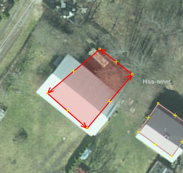
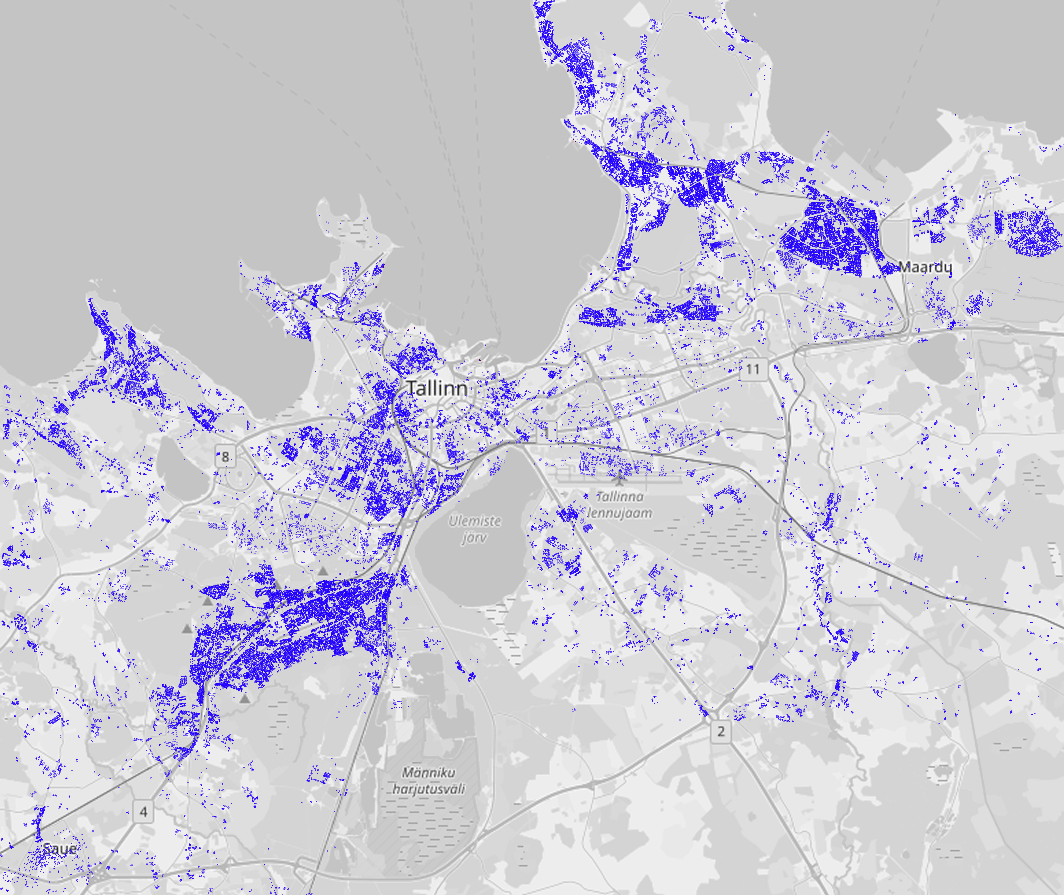
вт, 24 сент. 2019 г. в 23:47, <[email protected]>:

> Send Talk-ee mailing list submissions to
>         [email protected]
>
> To subscribe or unsubscribe via the World Wide Web, visit
>         https://lists.openstreetmap.org/listinfo/talk-ee
> or, via email, send a message with subject or body 'help' to
>         [email protected]
>
> You can reach the person managing the list at
>         [email protected]
>
> When replying, please edit your Subject line so it is more specific
> than "Re: Contents of Talk-ee digest..."
>
>
> Today's Topics:
>
>    1. Maa-amet Tase 6 (maaüksuse nimi) – addr:place või
>       addr:housename? (SviMik)
>    2. Re:  Maa-amet Tase 6 (maaüksuse nimi) – addr:place või
>       addr:housename? (Jaak Laineste)
>    3. Re: verbatium buiding import discussion (Jaak Laineste)
>    4. Re: verbatium buiding import discussion (SviMik)
>
>
> ----------------------------------------------------------------------
>
> Message: 1
> Date: Tue, 24 Sep 2019 17:51:48 +0300
> From: SviMik <[email protected]>
> To: [email protected]
> Subject: [Talk-ee] Maa-amet Tase 6 (maaüksuse nimi) – addr:place
>         või addr:housename?
> Message-ID: <[email protected]>
> Content-Type: text/plain; charset=utf-8
>
> Hi all,
>
> I have a tagging puzzle here. Maa-amet classifies address parts in the
> following way:
>
> Tase 3 – asustusüksus ja linnaosa
> Tase 4 – väikekoht
> Tase 5 – liikluspind (tänav)
> Tase 6 – maaüksuse nimi
> Tase 7 – aadressi number
>
> The problem is, that many buildings in Estonia do not have Tase 5 (street
> name), but instead have Tase 6 (lot name) and may or may not have Tase 7
> (housenumber) at the same time.
>
> According to OSM wiki, addr:place is "part of an address which refers to
> the name of some territorial zone".
> Looks perfect so far, "the name of some territorial zone" is literally
> "maaüksuse nimi".
> But...
> 1. addr:place requires place=* node or area to be mapped too, which is not
> really doable for every land lot.
> 2. I'm already using addr:place for Tase 4 (väikekoht, aiandusühistu, etc)
> which fits better for this role.
>
> We could use addr:housename for this instead.
> Indeed, Tase 6 is often used as a replacement for the street+number
> scheme, and in most cases is literally the property name.
> But...
> 1. Sometimes Tase 6 comes with Tase 7 (housenumber). I'm not sure if
> addr:housename can be used together with addr:housenumber, the
> addr:housename sounds like it must be the final address part.
>
> Examples with house number:
>
> Harju maakond;Kuusalu vald;Leesi küla;Kasemäe;1
> Harju maakond;Kuusalu vald;Leesi küla;Kasemäe;2
> - here Kasemäe is tase6, not street (tase5), but it still uses house
> numbering. This example looks like addr:place.
>
> Lääne-Viru maakond;Kadrina vald;Arbavere küla;Palkoja baas
> Harju maakond;Kuusalu vald;Vihasoo küla;Pumbamaja
> Harju maakond;Anija vald;Härmakosu küla;Härmakosu tehnopark
> - here the last part is tase6 too. They don't have house numbers, and
> these examles do look like addr:housename.
>
> So, the questions is: where exactly do I put the Maa-amet "Tase 6" address
> part in OSM tagging scheme?
> And is it OK to use addr:housename together with addr:housenumber?
>
> --
> SviMik
>
> ------------------------------
>
> Message: 2
> Date: Tue, 24 Sep 2019 18:16:23 +0300
> From: Jaak Laineste <[email protected]>
> To: SviMik <[email protected]>, OpenStreetMap Estonia
>         <[email protected]>
> Subject: Re: [Talk-ee]  Maa-amet Tase 6 (maaüksuse nimi) –
>         addr:place või addr:housename?
> Message-ID: <[email protected]>
> Content-Type: text/plain;       charset=utf-8
>
>
> There is a wiki page: https://wiki.openstreetmap.org/wiki/Et:Key:addr .,
> I think it is basically tase 5: housename, tase 6: housenumber if I get the
> question right.
>
> Feel free to enhance the wiki page, not everyone reads talk-ee, but wiki
> is more official doc :)
>
>
> Jaak
>
>
> > On 24 Sep 2019, at 17:51, SviMik via Talk-ee <[email protected]>
> wrote:
> >
> > Hi all,
> >
> > I have a tagging puzzle here. Maa-amet classifies address parts in the
> following way:
> >
> > Tase 3 – asustusüksus ja linnaosa
> > Tase 4 – väikekoht
> > Tase 5 – liikluspind (tänav)
> > Tase 6 – maaüksuse nimi
> > Tase 7 – aadressi number
> >
> > The problem is, that many buildings in Estonia do not have Tase 5
> (street name), but instead have Tase 6 (lot name) and may or may not have
> Tase 7 (housenumber) at the same time.
> >
> > According to OSM wiki, addr:place is "part of an address which refers to
> the name of some territorial zone".
> > Looks perfect so far, "the name of some territorial zone" is literally
> "maaüksuse nimi".
> > But...
> > 1. addr:place requires place=* node or area to be mapped too, which is
> not really doable for every land lot.
> > 2. I'm already using addr:place for Tase 4 (väikekoht, aiandusühistu,
> etc) which fits better for this role.
> >
> > We could use addr:housename for this instead.
> > Indeed, Tase 6 is often used as a replacement for the street+number
> scheme, and in most cases is literally the property name.
> > But...
> > 1. Sometimes Tase 6 comes with Tase 7 (housenumber). I'm not sure if
> addr:housename can be used together with addr:housenumber, the
> addr:housename sounds like it must be the final address part.
> >
> > Examples with house number:
> >
> > Harju maakond;Kuusalu vald;Leesi küla;Kasemäe;1
> > Harju maakond;Kuusalu vald;Leesi küla;Kasemäe;2
> > - here Kasemäe is tase6, not street (tase5), but it still uses house
> numbering. This example looks like addr:place.
> >
> > Lääne-Viru maakond;Kadrina vald;Arbavere küla;Palkoja baas
> > Harju maakond;Kuusalu vald;Vihasoo küla;Pumbamaja
> > Harju maakond;Anija vald;Härmakosu küla;Härmakosu tehnopark
> > - here the last part is tase6 too. They don't have house numbers, and
> these examles do look like addr:housename.
> >
> > So, the questions is: where exactly do I put the Maa-amet "Tase 6"
> address part in OSM tagging scheme?
> > And is it OK to use addr:housename together with addr:housenumber?
> >
> > --
> > SviMik
> > _______________________________________________
> > Talk-ee mailing list
> > [email protected]
> > https://lists.openstreetmap.org/listinfo/talk-ee
>
>
>
>
> ------------------------------
>
> Message: 3
> Date: Tue, 24 Sep 2019 22:08:08 +0300
> From: Jaak Laineste <[email protected]>
> To: SviMik <[email protected]>
> Cc: OpenStreetMap Estonia <[email protected]>
> Subject: Re: [Talk-ee] verbatium buiding import discussion
> Message-ID: <[email protected]>
> Content-Type: text/plain;       charset=utf-8
>
>
> These txt reports with IDs are not too visual, can you create any
> renderable file for josm (.osm for example) or screenshot to show the
> community what it really means? Are the building under question random or
> somehow in specific areas etc.  I dont know if there is any "test osm
> server” for such experiments nowadays somewhere, probably not.
>
> Jaak
>
> > On 24 Sep 2019, at 07:50, SviMik <[email protected]> wrote:
> >
> > I have analyzed the largest verbatium's import (changesets 591093,
> 579407, 572107, 569277, 569055 (ways) + 561094, 559707, 558636, 558056,
> 557568, 557358, 557193, 556899 (nodes only)), which was made in 2008. That
> covers 86.7% of all his edits.
> > The import was covering Tallinn, Saue and Maardu. Turned out verbatium
> wasn't particulary active outside Harjumaa.
> > There were total 67813 ways imported, 9032 of them are already deleted
> by other editors, and 17878 were changed either in geometry or tags*
> department (15529 has a geometry change, and 5077 has a tag change), which
> leaves 40903 buildings for deletion.
> > * I did not count the following tags because they are part of my imports
> anyway: addr:city, addr:country, addr:housenumber, addr:street,
> maaamet:ETAK, maaamet:orig_tunnus, source, source:addr, addr2:*
> > * If some change was reverted I do not count it as a change, because I
> only compare the first and the last version
> >
> > Here is the list of ways for deletion:
> > http://svimik.com/verbatium_import1_ways_unchanged1.txt
> >
> > Here is the full report for all the 67813 ways:
> > http://svimik.com/verbatium_import1_ways1.csv
> >
> > Full list of his changesets:
> > http://svimik.com/verbatium_changesets.xls
> >
> > Currently, the bbox of his changesets has 91324 buildings, which
> means... We're gonna delete 44.79% of Saue-Tallinn-Maardu buildings. That
> gonna be interesting. Should we split it by 10k for example? Or just start
> with Maardu and see what happens?
> >
> >
> > Воскресенье, 15 сентября 2019, 9:42 +03:00 от "Jaak Laineste" <
> [email protected]>:
> >> Hoi,
> >>
> >> Jah, need peaks kustutama. Enne võiks teha muudatuse analüüsi - kui
> palju ja
> >> kus kustutataks, ega mõned linnad kohe väga tühjaks ei jää.
> >>
> >> Jaak
> >>
> >> p.s. sama asi ka corine impordi osade tag-idega, näiteks põllud
> (field), need
> >> on pigem müra kui info kaardil.
> >>
> >>
> >>
> >>> On 14 Sep 2019, at 15:34, SviMik via Talk-ee <
> [email protected]>
> >> wrote:
> >>>
> >>> Hi everyone!
> >>>
> >>> I'd like to discuss the import made by verbatium in 2008:
> >>> https://www.openstreetmap.org/changeset/569055
> >>> (...and other similar changesets)
> >>>
> >>> There are two issues with that import:
> >>> 1. Unknown data source with unknown license (probably it was a Garmin
> map
> >> judging by the Type=0x13 tag)
> >>> 2. Poor quality of the data. If you see a building distorted like this:
> >> http://svimik.com/verbatiumimport1.png
> >>> - you can be sure it's verbatium's. Maybe it was OK in 2008, but in
> 2019 we
> >> have much better options.
> >>>
> >>> What can be done:
> >>> 1. Remove all buildings which geometry and tags were not edited since
> the
> >> initial import. For the tags the following exceptions can be made
> because they
> >> were automatic edits:
> >>> - User xybot has fixed the tag typo (buildung=yes) in the initial
> import and
> >> added its own tag (created_by=xybot)
> >>> - User juhanjuku has removed the Type=0x13 and created_by=xybot tags
> >>> - User SviMik_import has imported the address tags to these buildings
> from
> >> the Maa-amet database (nothing that can't be imported again)
> >>> 2. Proceed with the Maa-amet building import as usual
> >>>
> >>> It will solve:
> >>> 1. The license issue (if there is any)
> >>> 2. The quality issue (if you agree there is an issue)
> >>> 3. Will update the map in general, for example the demolished
> buildings will
> >> be removed from OSM.
> >>>
> >>> For buildings which geometry was changed by other contributors after
> the
> >> initial import - we can assume both license and quality issues were
> solved
> >> since they no longer contain the imported geometry. I know it's a grey
> field,
> >> and I'm not sure it works like that, but at least these buildings do
> have some
> >> excuse to stay.
> >>>
> >>> For buildings which geometry was NOT changed, but some POI tags were
> added -
> >> let them stay for now and discuss it later if needed. I suspect it will
> be a
> >> rare case, but the exact number is unknown right now.
> >>>
> >>> Questions:
> >>> 1. Has anyone else digged into the issue, maybe asked verbatium
> himself?
> >>> 2. Can anyone confirm that the import indeed has the license problem?
> >>> 3. Is the proposed plan good? (in case if you agree that it needs to be
> >> fixed)
> >>>
> >>> --
> >>> SviMik
> >>> _______________________________________________
> >>> Talk-ee mailing list
> >>> [email protected]
> >>> https://lists.openstreetmap.org/listinfo/talk-ee
> >>
> >>
> >
> >
> > --
> > Svjatoslav Mikhailov
>
>
>
>
> ------------------------------
>
> Message: 4
> Date: Tue, 24 Sep 2019 23:46:36 +0300
> From: SviMik <[email protected]>
> To: Jaak Laineste <[email protected]>
> Cc: OpenStreetMap Estonia <[email protected]>
> Subject: Re: [Talk-ee] verbatium buiding import discussion
> Message-ID: <[email protected]>
> Content-Type: text/plain; charset=utf-8
>
> http://svimik.com/verbatiumimportmap1.png
> Here's the screenshot. Not precise, but gives some idea.
> 40903 buildings is a bit too much for JOSM.
>
>
> Вторник, 24 сентября 2019, 22:08 +03:00 от "Jaak Laineste" <
> [email protected]>:
> >
> > These txt reports with IDs are not too visual, can you create any
> renderable
> > file for josm (.osm for example) or screenshot to show the community
> what it
> > really means? Are the building under question random or somehow in
> specific
> > areas etc.  I dont know if there is any "test osm server” for such
> experiments
> > nowadays somewhere, probably not.
> >
> > Jaak
> >
> > > On 24 Sep 2019, at 07:50, SviMik <[email protected]> wrote:
> > >
> > > I have analyzed the largest verbatium's import (changesets 591093,
> 579407,
> > 572107, 569277, 569055 (ways) + 561094, 559707, 558636, 558056, 557568,
> > 557358, 557193, 556899 (nodes only)), which was made in 2008. That covers
> > 86.7% of all his edits.
> > > The import was covering Tallinn, Saue and Maardu. Turned out verbatium
> > wasn't particulary active outside Harjumaa.
> > > There were total 67813 ways imported, 9032 of them are already deleted
> by
> > other editors, and 17878 were changed either in geometry or tags*
> department
> > (15529 has a geometry change, and 5077 has a tag change), which leaves
> 40903
> > buildings for deletion.
> > > * I did not count the following tags because they are part of my
> imports
> > anyway: addr:city, addr:country, addr:housenumber, addr:street,
> maaamet:ETAK,
> > maaamet:orig_tunnus, source, source:addr, addr2:*
> > > * If some change was reverted I do not count it as a change, because I
> only
> > compare the first and the last version
> > >
> > > Here is the list of ways for deletion:
> > > http://svimik.com/verbatium_import1_ways_unchanged1.txt
> > >
> > > Here is the full report for all the 67813 ways:
> > > http://svimik.com/verbatium_import1_ways1.csv
> > >
> > > Full list of his changesets:
> > > http://svimik.com/verbatium_changesets.xls
> > >
> > > Currently, the bbox of his changesets has 91324 buildings, which
> means...
> > We're gonna delete 44.79% of Saue-Tallinn-Maardu buildings. That gonna be
> > interesting. Should we split it by 10k for example? Or just start with
> Maardu
> > and see what happens?
> > >
> > >
> > > Воскресенье, 15 сентября 2019, 9:42 +03:00 от "Jaak Laineste"
> > <[email protected]>:
> > >> Hoi,
> > >>
> > >> Jah, need peaks kustutama. Enne võiks teha muudatuse analüüsi - kui
> palju
> > ja
> > >> kus kustutataks, ega mõned linnad kohe väga tühjaks ei jää.
> > >>
> > >> Jaak
> > >>
> > >> p.s. sama asi ka corine impordi osade tag-idega, näiteks põllud
> (field),
> > need
> > >> on pigem müra kui info kaardil.
> > >>
> > >>
> > >>
> > >>> On 14 Sep 2019, at 15:34, SviMik via Talk-ee <
> [email protected]>
> > >> wrote:
> > >>>
> > >>> Hi everyone!
> > >>>
> > >>> I'd like to discuss the import made by verbatium in 2008:
> > >>> https://www.openstreetmap.org/changeset/569055
> > >>> (...and other similar changesets)
> > >>>
> > >>> There are two issues with that import:
> > >>> 1. Unknown data source with unknown license (probably it was a
> Garmin map
> > >> judging by the Type=0x13 tag)
> > >>> 2. Poor quality of the data. If you see a building distorted like
> this:
> > >> http://svimik.com/verbatiumimport1.png
> > >>> - you can be sure it's verbatium's. Maybe it was OK in 2008, but in
> 2019
> > we
> > >> have much better options.
> > >>>
> > >>> What can be done:
> > >>> 1. Remove all buildings which geometry and tags were not edited
> since the
> > >> initial import. For the tags the following exceptions can be made
> because
> > they
> > >> were automatic edits:
> > >>> - User xybot has fixed the tag typo (buildung=yes) in the initial
> import
> > and
> > >> added its own tag (created_by=xybot)
> > >>> - User juhanjuku has removed the Type=0x13 and created_by=xybot tags
> > >>> - User SviMik_import has imported the address tags to these
> buildings from
> > >> the Maa-amet database (nothing that can't be imported again)
> > >>> 2. Proceed with the Maa-amet building import as usual
> > >>>
> > >>> It will solve:
> > >>> 1. The license issue (if there is any)
> > >>> 2. The quality issue (if you agree there is an issue)
> > >>> 3. Will update the map in general, for example the demolished
> buildings
> > will
> > >> be removed from OSM.
> > >>>
> > >>> For buildings which geometry was changed by other contributors after
> the
> > >> initial import - we can assume both license and quality issues were
> solved
> > >> since they no longer contain the imported geometry. I know it's a grey
> > field,
> > >> and I'm not sure it works like that, but at least these buildings do
> have
> > some
> > >> excuse to stay.
> > >>>
> > >>> For buildings which geometry was NOT changed, but some POI tags were
> added
> > -
> > >> let them stay for now and discuss it later if needed. I suspect it
> will be
> > a
> > >> rare case, but the exact number is unknown right now.
> > >>>
> > >>> Questions:
> > >>> 1. Has anyone else digged into the issue, maybe asked verbatium
> himself?
> > >>> 2. Can anyone confirm that the import indeed has the license problem?
> > >>> 3. Is the proposed plan good? (in case if you agree that it needs to
> be
> > >> fixed)
> > >>>
> > >>> --
> > >>> SviMik
> > >>> _______________________________________________
> > >>> Talk-ee mailing list
> > >>> [email protected]
> > >>> https://lists.openstreetmap.org/listinfo/talk-ee
> > >>
> > >>
> > >
> > >
>
> ------------------------------
>
> Subject: Digest Footer
>
> _______________________________________________
> Talk-ee mailing list
> [email protected]
> https://lists.openstreetmap.org/listinfo/talk-ee
>
>
> ------------------------------
>
> End of Talk-ee Digest, Vol 95, Issue 7
> **************************************
>
_______________________________________________
Talk-ee mailing list
[email protected]
https://lists.openstreetmap.org/listinfo/talk-ee