A few months ago I compared the length of roads on the OSM database against
the figures quoted by the Department for transport, and posted the results
here.
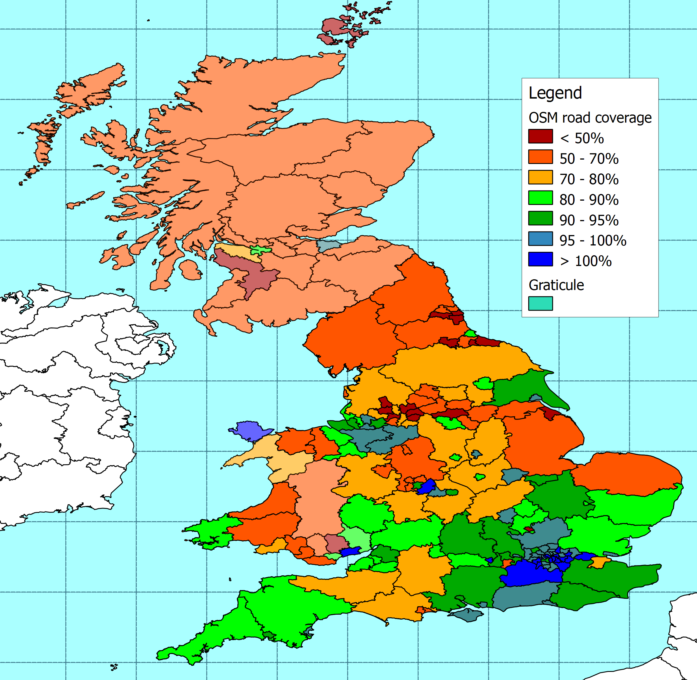
I've now updated the figures using the OSM database extract at the end of
2009.


The resulting map is here -
http://www.reedhome.org.uk/Documents/OSMCoverJan2010.png and the data from
my analysis is here -
http://www.reedhome.org.uk/Documents/OSMCoverageJan2010.csv .


The DfT data can be found here -
http://www.dft.gov.uk/pgr/statistics/datatablespublications/roadstraffic/roa
dlengths/


In summary, the length of roads on OSM that I am able to compare with DfT
data has increased by around 5% if the last few months.


The south east of England is still generally better covered than the north,
but there is improved coverage all over the place. The biggest increase in
coverage is in Cornwall, which has moved  from less than 50% coverage to
more than 80%. There are also significant improvements in Plymouth, and a
number of cities in northern England and the West Midlands.


The length of roads plotted for all of the following authorities has
increased by more than 20%:


.         Cornwall

.         Plymouth

.         Bury

.         Wirral

.         Telford & Wrekin

.         Bolton

.         Rochdale

.         Oldham

.         Barnsley

.         Stoke-on-Trent


Apart from minor tweaking to the way I categorise roads, I have removed
anthing tagged "Motorway link" from the motorway totals, because I've
discovered from the Department for Transport that they currently don't count
links towards the length of motorways. This doesn't make a huge difference
to the overall totals of course.


For anyone wanting to recreate this, I should point out that I'm still using
the admin boundaries as they stood four months ago. The reason for this is
that I had to do a fair amount of tidying up last time to remove overlaps
and inconsistencies in the boundaries. There have been some changes to the
data for admin boundaries on OSM over the last few months, and I really
ought to do the same tidying again, but it takes forever, and I don't have
time at the moment. That means that I've not picked up some new boundaries
in Wales that have been added since I did the last extract. In England I
don't think this can be making a great deal of difference, except possibly
at the margins of some local authorities.


Where I can't get local authority boundaries from OSM yet, I've continued to
use the EU regions instead. This mostly affects Scotland, where I can't find
any local authority boundaries on OSM. I don't have the EU regional
boundaries at the same level of precision as OSM admin boundaries so these
figures will be a but fuzzy round the edges.


As before, thoughts and comments are invited, and welcome.
_______________________________________________
Talk-GB mailing list
[email protected]
http://lists.openstreetmap.org/listinfo/talk-gb