On 18/03/2011 22:56, Kev js1982 wrote:
Resurrecting an old thread I know but with the NSPD Open data also
being available allowing Northern Ireland to be generated and having
access to an otherwise idle 64bit server I've taken the opportunity to
revisit this, and have successfully created the shapefiles (it only
took the server 12 days to generate the blighters - it managed to
generate Z16 tiles for the whole of Europe and Z18 for the British
Isles in just 36 hours - meh!) but now have one more obstacle to
overcome...
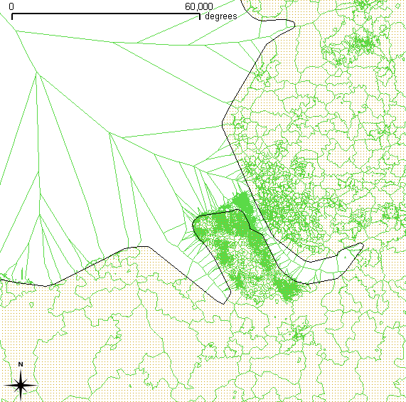
The Veroni thingy obviously generates the tiles so they butt up
against one another which works perfectly here in the landlocked East
Midlands, but goes somewhat wrong in coastal areas (Fig 1).
My thought here is that the "World Boundaries" shape file can be used
to trim the coastal boundaries to be locked to land so that the map
looks "nice" (i.e. postcodes don't end up in the sea save for a little
overlap on beaches) - Indeed if you add the World Boundaries file to
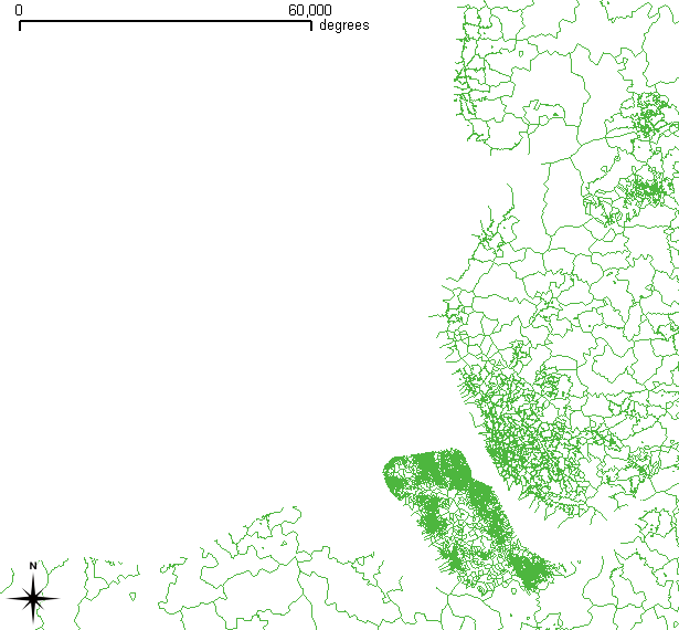
Quantum GIS and use the "Clip Tool" you end up with what visually
looks correct ( Fig. 3) but if you then hide the World Boundaries file
the problem becomes obvious (Fig 2.)
What I want to know, is it possible to trim the postcode shapes so
that nothing outside another set of shapes (i.e. the British Isles
landmass) is included, but instead of leaving gaps the postcode shapes
(e.g. FY3 1) are adjusted so that the line runs along the coast line?
i.e. I would be left with something visually the same as Fig. 3 but
with the coastlines part of the NNXX-X shapefile layer, and more
specifically the correct polygon (e.g. the FY3 1 polygon).
Kev
Fig 1 - Postcode areas in south west Lancashire and the north Wales
coast (green = NNXX-X shapefile, blackline and dotted area uses the
worldboundaries file)
http://kjs.me.uk/3rdparty/osm/SouthWestLancs-NNXX-X.png
Fig 2 - After using Quantum GIS's "Clip" tool -
http://kjs.me.uk/3rdparty/osm/SouthWestLancs-NNXX-X_trimmed.png
Fig 3 - After adding the "World Boundaries" back on. -
SouthWestLancs-NNXX-X_trimmed_withwb.png
/Open Street Map data licenced under the Creative Commons
Attribution-Share Alike 2.0 license
<http://creativecommons.org/licenses/by-sa/2.0/> by the OpenStreetMap
<http://openstreetmap.org/>/ project and its contributors. /Maps
contain Ordnance Survey OpenData
<http://www.ordnancesurvey.co.uk/oswebsite/opendata/> © Crown
copyright and database right 2010./ /Postcode data in Great Britain is
provided by Code-Point Open which contains Royal Mail data © Royal
Mail copyright and database right 2010./ /Postcode data in Northern
Ireland is from the NSPD Open
<http://www.ons.gov.uk/about-statistics/geography/products/geog-products-postcode/nspd/>
which contains National Statistics data © Crown copyright and database
right 2010. /
On Fri, Apr 30, 2010 at 12:30, Kev js1982 <[email protected]
<mailto:[email protected]>> wrote:
    Hi Dave,

    Thanks for providing the shapefiles for download - they did the
    job nicely.

    One thing I have noticed (which also afflicts
    random.dev.openstreetmap.org
    <http://random.dev.openstreetmap.org>) is that a few postcode
    area/districts are missing - namely

    FY2 - (North Shore) Blackpool, Lancs
    PE11 - Spalding, Lincs
    PL17 - Callington, Cornwall

    Using the code point download (which I got via the MySociety
    mirror) shows that these postcodes do exist.

    Also one of the AB ones (12 or 21 IIRC) for some reason includes
    parts of Éire, Spain, Portugal and atlantic; while HS includes
    Reykjavik

    Just thought you'd like to know there is a possible error with the
    conversion process.

    Nice work though - been after a postcode map for a while, and to
    go from an A5 diagram to full "google maps" goodness in one swoop
    is awesome!

    Regards

    Kev Swindells.


    On Mon, Apr 26, 2010 at 5:29 PM, Dave Stubbs
    <[email protected] <mailto:[email protected]>> wrote:

        On Mon, Apr 26, 2010 at 5:15 PM, Kev js1982
        <[email protected] <mailto:[email protected]>> wrote:
        > On Mon, Apr 26, 2010 at 5:00 PM, Kev js1982
        <[email protected] <mailto:[email protected]>> wrote:
        >>
        >> Thanks for that Dave - really useful.
        >>
        >> One question though - which prj string/file do I need for
        these?
        >>
        >
        > Answering my own question - looks to be Google Mercator.
        >
        > http://spatialreference.org/ref/sr-org/6627/
        >
        > Kev Swindells
        >
        >

        Actually, for some obscure historical reason it's projected into
        "+proj=merc" which is srs 3395.

        Close to 900913, but not quite the same -- my mapnik stylesheet is
        then set to reproject to google mercator for the tile generation.

        Dave


_______________________________________________
Talk-GB mailing list
[email protected]
http://lists.openstreetmap.org/listinfo/talk-gb
You ought to be able to do this with Intersect first which will divide
your FY3 1 polygon into two along the coastline & then clip the result
to only get the ones inside the coastline. At least if I understand the
problem correctly.
I've never got the packaged Voronoi working so have only played with
Delauney triangulation doing the same process.
Jerry
_______________________________________________
Talk-GB mailing list
[email protected]
http://lists.openstreetmap.org/listinfo/talk-gb