Hola, joost
En la comunidad Brasileña ya tuvimos muchas discusiones sobre la
clasificación de carreteras y calles. Llegamos en una definición que es
muy buena para vías rurales, pero, en mi opinión, no es todavía muy
clara para las vías urbanas (los principales conflictos son entre calles
residenciales y terciarias):
http://wiki.openstreetmap.org/wiki/Pt-br:Guia_de_Mapeamento_do_Territ%C3%B3rio_Brasileiro#Classifica.C3.A7.C3.A3o_de_vias_.28original.29
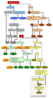
Hay también un flowchart bastante complejo:
http://wiki.openstreetmap.org/w/images/thumb/1/12/Br-classification-flowchart-pt.png/180px-Br-classification-flowchart-pt.png
El problema que veo con la propuesta de clasificación de acuerdo con la
importancia da la vía es que en comunidades con muchos colaboradores
puede generar muchos conflictos, pues la importancia de una vía no es
una definición objetiva. Pero si ya está siendo utilizada en África, no
soy contra que sea utilizada en países con pocos colaboradores y con una
infraestructura de carreteras poco jerarquizada y definida.
hasta luego,
wille


On 14-12-2014 19:01, joost schouppe wrote:
Hello Latin America,
There were a lot of reactions to my earlier post about mapping the
quality of roads in Latin America. I hoped we could talk about this at
SOTM, but that didn't happen. So here I'd like to revive the
discussion. I learned a lot since then, mostly thanks to Marco
Antonio. Estoy escribiendo en inglés como parece más fácil para los
brasileños. Puedo traducir si le hace falta a alguien.
What I'd like us to do now:
- As a Latin community we keep mapping surface and show off the
progress we make. I'll try to make some statistics about the progess
we make (and publish them on global.swing.eu <http://global.swing.eu> )
- As a Latin community we try to get surface included in the standard
mapnik map. I made a simple
mock-up:https://github.com/gravitystorm/openstreetmap-carto/issues/110#issuecomment-66274450.
From the reactions, it seems that they will only consider a proposal
which is already almost ready for inclusion in the main code. So that
means we have to get a Tilemill running and play around with the
stylesheet ourselves. I've got the History Renderer installed, and
I'll try to play a bit with the xml stylesheet that uses... We would
have to work out most of the details, and maybe even make changes to
the style of tunnels or planned roads. If this proposal is rejected
(which I have a feeling is quite possible), we might have to start
playing it politically. Maybe trying to get Mapbox and HOT involved.
Anyone have some experience with Tilemill? Or another tool to make
nice mockups with OSM data, based on standard Mapnik style?
In the longer term:
- Develop an Afro-Latin tagging scheme. Now there are many different
national interpretations of road tagging. That's not a good idea, as a
lot of our data users are international. The African tagging scheme is
good and simple: basically a road is classified higher if it is more
important. Quality of the road does not count. So a terrible dirt road
is still primary if it is the only connection between major cities.
But this tagging scheme does not use the trunk road classification. My
proposal would be to use this trunk road tag, but only for the most
important roads that are not freeways, that are paved and that are at
least two lanes wide. With this slight adaptation, I think we could
happily map Latin America. And it would stick very close to current
practice and the African practice, making it easy to have a common
Afro-Latino scheme. In turn, that should make it easier to push for
changes relevant to our community. Anyway, most people seem to agree
that the only valid reason to map a road in a higher classification is
that the road is more important (see eg
http://www.openstreetmap.org/user/Mark%20Newnham/diary/20736).
- Even if after over six years, we do manage to get mapnik to show
road quality, I still see a use for a Latin mapview. I think the Mapa
Ecologico is a great example. Here rivers and roads get mapped much
more prominently at higher zoom levels, which for the much less
populated continent makes a lot of sense. I talked to Linhares and he
would like to share his stylesheet. How about we make a Latin OSM
portal with our own map style and maybe even a more pronouncable name,
like www.MapaMundiAbierto.org <http://www.MapaMundiAbierto.org> or
www.OtroServiciodeMapas.org <http://www.OtroServiciodeMapas.org>? That
would allow us to highlight things which are more important in this
part of the world. After a presentation in Bolivia, I got the idea
that they really did get the point when someone asked if we could make
a mapa de las fiestas! Why not : )
So, who wants in?

Joost


_______________________________________________
talk-latam mailing list
[email protected]
https://lists.openstreetmap.org/listinfo/talk-latam
_______________________________________________
talk-latam mailing list
[email protected]
https://lists.openstreetmap.org/listinfo/talk-latam