Here you go

Regards
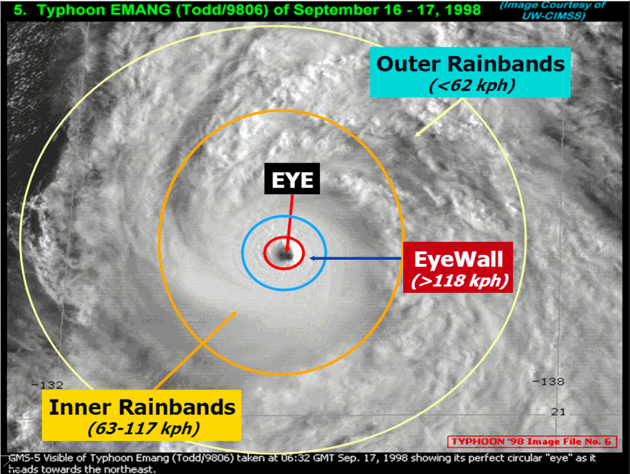
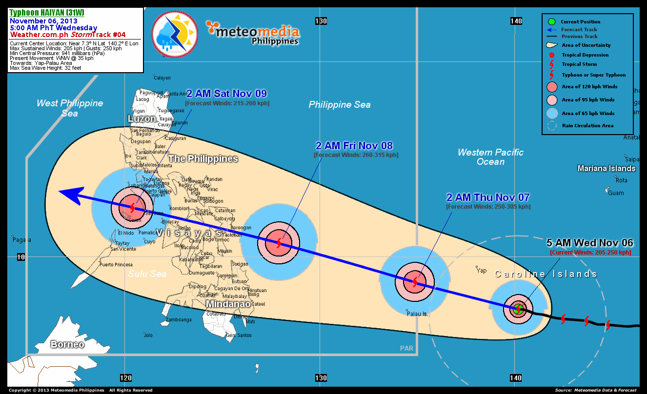
Mark Cupitt

"If we change the world, let it bear the mark of our intelligence"

See me on LinkedIn <http://ph.linkedin.com/in/markcupitt>

*See me on StackExchange <http://gis.stackexchange.com/users/17846/mark-c>*

===============================================================================================
The contents of this email are intended only for the individual(s) to whom
it is addressed and may contain
confidential or privileged information. If you are not the intended
recipient, you must not disclose, copy, distribute,
or use the contents of this email. If you have received this email in
error, please notify the sender immediately and
delete the email and any attachments.
===============================================================================================


---------- Forwarded message ----------
From: Typhoon2000.com (Michael V. Padua) <[email protected]>
Date: Wed, Nov 6, 2013 at 8:35 AM
Subject: Powerful Typhoon HAIYAN Update #004
To: [email protected]


*for Wednesday, 06 November 2013 [8:35 AM PhT]*
 <http://www.typhoon2000.ph/advisory.html#>
<http://www.typhoon2000.ph/advisory.html#>
<http://www.typhoon2000.ph/advisory.html#>
<http://www.typhoon2000.ph/advisory.html#>
<http://www.typhoon2000.ph/advisory.html#>
------------------------------

*WEATHER.COM.PH <http://WEATHER.COM.PH> TROPICAL CYCLONE UPDATES*
*TYPHOON HAIYAN UPDATE NUMBER 004 *
Issued at: 6:00 AM PhT (22:00 GMT) Wednesday 06 November 2013
Next Update: 12:00 NN PhT (04:00 GMT) Wednesday 06 November 2013
------------------------------

HAIYAN approaching Super Typhoon (STY) status as it rapidly gained strength
due to the emergence of a pinhole-sized eye a few hours ago...now poses a
serious threat to Eastern Visayas and Northeastern Mindanao. The initial
potential landfall area of this typhoon remains along the Samar-Leyte Area
on *Friday morning, November 08*.

*This typhoon is similar in track and strength of Super Typhoon MIKE
(RUPING) which passed across the Visayas in November of 1991 and devastated
much of Metro Cebu. Residents living along the eastern seaboards of the
Philippines from Northern Quezon...Bicol Region...down to Northeastern
Mindanao should closely monitor the approach of this potentially
destructive typhoon. Plans for emergency situations and/or disaster
management planning must be implemented beginning today as the storm is
only 3 days away from hitting land.*

Meanwhile, *Tropical Depression 30W (WILMA)* has accelerated and is
approaching the coast of Southern Vietnam. As of 5:00 am today, its center
was estimated about *385 km ESE of Nha Trang, Vietnam (near 11.8N 112.7E).
With maximum winds of 55 kph near the center and was moving westward at 31
kph in the general direction of Southern Vietnam.*

Residents and visitors along Northeastern Mindanao, Visayas, Bicol Region
and Eastern Luzon should closely monitor the development of Haiyan.

Do not use this for life or death decisions. This update is intended for
additional information purposes only. Kindly refer to your national weather
agency for official warnings, advisories or bulletins.


*CURRENT STORM ANALYSIS*

As of 5:00 am today, the pin-hole eye of TY Haiyan was located over the
western part of the Caroline Islands...about 335 km southeast of Colonia,
Yap (FSM) or 1,690 km southeast of Borongan City, Samar,
Philippines...currently moving quickly west-northwest with an accelerated
forward speed of 35 km/hr towards Yap-Palau Area.

Maximum Sustained Winds (1-min. avg) have rapidly increased to 205 km/hr
near the center with higher gusts. *Typhoon Force Winds (118 km/hr or more)
extend outward up to 45 kilometers from the center...and Tropical Storm
Force Winds (63-117 km/hr) extend outward up to 165 kilometers from the
center.* TY Haiyan remains a
small-sized<http://www.typhoon2000.ph/tcsizes.htm>tropical cyclone
with a diameter of 555 kilometers across.


*2-DAY FORECAST OUTLOOK**

TY Haiyan is expected to move in a generally straight, west-northwest track
throughout the forecast period. *On the forecast track, the core of TY
Haiyan will passing in between the islands of Yap and Palau by Wednesday
afternoon and evening...and will enter the Philippine Area of
Responsibility (PAR) during the early morning hours of Thursday...and move
across the South Philippine Sea. By early Friday morning, Haiyan will be at
near landfall, approaching the shores of Southern Samar and Eastern Leyte.*

TY Haiyan will continue to rapidly intensify within the next 24 to 48 hours
as the system moves over the warmer sea surface temperatures of the
Philippine Sea...and could become an extremely dangerous Category 5 STY on
Thursday early morning just before it makes landfall. Advance Intensity
Forecast (AIF) shows its 1-minute maximum sustained winds increasing to 260
km/hr between the evening of Wednesday and early Thursday morning.

The following is the summary of the 2-day forecast outlook and an *extended
3-day forecast* on this system:

 *THURSDAY EARLY MORNING:* Enters the P.A.R. at Category 4 strength while
passing close to the Republic of Palau...moving over the South Philippine
Sea...about 160 km north-northeast of Koror, Palau *[2AM NOV 07: 8.7N
134.9E @ 250kph]*.
 *FRIDAY EARLY MORNING:* Strengthens to a Category 5 STY as it prepares to
make landfall over Southern Samar...about 290 km southeast of Borongan
City, Eastern Samar *[2AM NOV 08: 10.7N 127.9E @ 260kph]*.
 *SATURDAY EARLY MORNING:* Moving across Mindoro Strait after traversing
Northern Visayas...weakens to Category 4...about 60 km north-northeast of
Coron, Palawan *[2AM NOV 09: 12.5N 120.4E @ 215kph]*.

*Please be reminded that the *Forecast Outlook* changes every 6 hours, and
the *Day 2 and 3 Forecast Track* has an average error of 100 and 250 km
respectively...while the *wind speed forecast error*, averages 35 kph per
day. Therefore, *a turn to the left or right of its future track and
changes in its wind speed must be anticipated from time to time*.


*EFFECTS & HAZARDS SUMMARY*

Below is the summary of the storm's parts and its hazards affecting
specific areas. You can also *view this image
link*<http://www.typhoon2000.ph/stormparts.gif>for you to understand
the parts.

 *PIN-HOLE EYE* - *over water.* *Possible calm and lull conditions* (with
<20 kph winds) will be expected inside the eye *(click here to know more
about the EYE <http://en.wikipedia.org/wiki/Eye_%28cyclone%29>).*
*EYEWALL* - where *Typhoon Conditions* with Typhoon Force Winds (>118 kph)
will be expected within this wall. *Affected Areas*: *None* *(click here to
know more about the Eyewall <http://www.aoml.noaa.gov/hrd/tcfaq/A11.html>).*
*INNER RAINBANDS* - where *Tropical Storm Conditions* with Tropical Storm
Force Winds (63-100 kph) will be expected. *Affected Areas*: *None.*
*OUTER RAINBANDS* - where *Tropical Depression Conditions* with light,
moderate to strong winds (30-62 kph) will be expected. *Affected Areas*: *Yap
State (Federated States of Micronesia) and approaching the Republic of
Palau** (click here to know more about Rainbands
<http://en.wikipedia.org/wiki/Rainband>)*.
*24HR TOTAL RAINFALL ACCUMULATION* - from *5 up to 100 mm (slight to heavy
rainfall)* can be expected along areas affected by the *outer & inner
rainbands (see above)*...with isolated amounts of *101 to 210 mm
(heavy)*along areas *near
the center* of Haiyan.

*Important Note*: Please keep in mind that the above forecast outlook,
effects and hazards summary changes every 6 to 12 hrs!
------------------------------


*CURRENT TECHNICAL INFORMATION*

Time/Date:* 5:00 AM PhT Wed Nov 06, 2013*
Class/Name:* TY Haiyan (31W)*
Location of Eye: *Near 7.3º N Lat 140.2º E Lon*
Distance 1:* 335 km SE of Yap State *
Distance 2:* 575 km E of P.A.R.*
Distance 3:* 630 km E of Republic of Palau*
Distance 4:* 1690 km SE of Borongan City*
Distance 5:* 1725 km ESE of Tacloban City*
Max*Winds* (1-min avg): *205 kph near the center*
Peak Wind Gusts: *250 kph *
Saffir-Simpson Hurricane Scale: *Category 3
<http://en.wikipedia.org/wiki/Saffir-Simpson>*
Present Movement:* WNW @ 35 kph*
Towards: *Yap-Palau Area*
CPA [ETA] to Samar-Leyte: * Friday Morning [between 7AM-9AM PhT]*
Minimum Central Pressure:* 941 millibars (hPa)*
T2K/WP *StormTracks* (for Public): *GIF
<http://www.typhoon2000.ph/activetrack2.gif> | Google Map (Flash)
<http://www.nueca.net/typhoon2001/>*
 * <http://icons-ecast.wunderground.com/data/images/wp201204_sat_anim.gif>*


*
__________________________________________________________________________________________________CURRENT
TRACKING MAP: [image:
http://www.typhoon2000.ph/advisorytrax/2013/yolanda04.gif]
_____________________________________________________________________________
CURRENT UW-CIMSS / MTSAT-2 SATELLITE ANIMATION:[image:
http://weather.com.ph/images/20131105225103.GIF]
__________________________________________________________________________________________________
CURRENT NOAA/MTSAT-2 INFRARED (IR) SATELLITE IMAGE:[image:
http://www.ssd.noaa.gov/PS/TROP/floaters/31W/imagery/rb0-lalo.jpg]
__________________________________________________________________________________________________
*
*NOTE:*

>> To know the meteorological terminologies and acronyms used on this
update visit the ff:

    http://typhoon2000.ph/tcterm.htm
    http://www.nhc.noaa.gov/aboutgloss.shtml
    http://www.nhc.noaa.gov/acronyms.shtml


*__________________________________________________________________________________________
*For the complete details on TY HAIYAN...go visit our website @:

> http://www.typhoon2000.com
> http://www.maybagyo.com
> http://www.typhoon2000.ph

:: Kindly view our site's disclaimer at:
   http://www.typhoon2000.ph/disclaimer.htm
*__________________________________________________________________________________________*


* <<<Typhoon2000.com Mobile >>>Get the latest SMS Storm Alerts!For more
details: Text T2K TYPHOON to 2800 (Globe/TM) | Offline (Smart/TNT) | 2288
(Sun) *Only P2.50 (Smart/Globe) / P2.00 (Sun) per msg received. Click here
<http://www.typhoon2000.ph/T2KSMS.pdf> on how to use this service (in PDF
file)Powered by: Synermaxx Corporation <http://www.synermaxx.com>*
------------------------------
*Copyright © 2013 Typhoon2000.com     All Rights Reserved*

 __._,_.___
  Reply via web
post<http://groups.yahoo.com/group/typhoon2000ph_stormlist/post;_ylc=X3oDMTJxYTZmdG1qBF9TAzk3MzU5NzE0BGdycElkAzEzNTE0NjU3BGdycHNwSWQDMTcwNTA4MzYxNQRtc2dJZAMxOTM4BHNlYwNmdHIEc2xrA3JwbHkEc3RpbWUDMTM4MzY5ODI3Mw--?act=reply&messageNum=1938>
 Reply
to sender
<[email protected]?subject=Re%3A%20Powerful%20Typhoon%20HAIYAN%20Update%20%23004>
 Reply
to group
<[email protected]?subject=Re%3A%20Powerful%20Typhoon%20HAIYAN%20Update%20%23004>
 Start
a New
Topic<http://groups.yahoo.com/group/typhoon2000ph_stormlist/post;_ylc=X3oDMTJmNm9raXQ2BF9TAzk3MzU5NzE0BGdycElkAzEzNTE0NjU3BGdycHNwSWQDMTcwNTA4MzYxNQRzZWMDZnRyBHNsawNudHBjBHN0aW1lAzEzODM2OTgyNzM->
 Messages
in this
topic<http://groups.yahoo.com/group/typhoon2000ph_stormlist/message/1938;_ylc=X3oDMTM1MGIwcjhlBF9TAzk3MzU5NzE0BGdycElkAzEzNTE0NjU3BGdycHNwSWQDMTcwNTA4MzYxNQRtc2dJZAMxOTM4BHNlYwNmdHIEc2xrA3Z0cGMEc3RpbWUDMTM4MzY5ODI3MwR0cGNJZAMxOTM4>(1)
Recent Activity:

   - New
Members<http://groups.yahoo.com/group/typhoon2000ph_stormlist/members;_ylc=X3oDMTJnY28wMHViBF9TAzk3MzU5NzE0BGdycElkAzEzNTE0NjU3BGdycHNwSWQDMTcwNTA4MzYxNQRzZWMDdnRsBHNsawN2bWJycwRzdGltZQMxMzgzNjk4Mjcz?o=6>
   20

 Visit Your
Group<http://groups.yahoo.com/group/typhoon2000ph_stormlist;_ylc=X3oDMTJmM250N2Y4BF9TAzk3MzU5NzE0BGdycElkAzEzNTE0NjU3BGdycHNwSWQDMTcwNTA4MzYxNQRzZWMDdnRsBHNsawN2Z2hwBHN0aW1lAzEzODM2OTgyNzM->
 [image: Yahoo!
Groups]<http://groups.yahoo.com/;_ylc=X3oDMTJlanI0a2YyBF9TAzk3NDc2NTkwBGdycElkAzEzNTE0NjU3BGdycHNwSWQDMTcwNTA4MzYxNQRzZWMDZnRyBHNsawNnZnAEc3RpbWUDMTM4MzY5ODI3Mw-->
Switch to:
Text-Only<[email protected]?subject=Change+Delivery+Format:+Traditional>,
Daily
Digest<[email protected]?subject=Email+Delivery:+Digest>•
Unsubscribe<[email protected]?subject=Unsubscribe>•
Terms
of Use <http://info.yahoo.com/legal/us/yahoo/utos/terms/> • Send us
Feedback
<[email protected]?subject=Feedback+on+the+redesigned+individual+mail+v1>
   .

__,_._,___
_______________________________________________
talk-ph mailing list
[email protected]
https://lists.openstreetmap.org/listinfo/talk-ph