On Sun, Aug 21, 2011 at 1:29 PM, Nathan Edgars II <[email protected]> wrote:
> On 8/21/2011 9:21 AM, Alan Mintz wrote:
>>
>> My understanding was that there are two options for California SR-60:
>>
>> 1) network=US:CA + ref=60
>> 2) ref=CA 60
>
> SR 60 is a good example, since it overlaps I-215 in Riverside. The network
> tag won't work here, since it needs to be both US:I and US:CA.
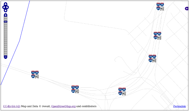
Not a problem.  This has been solved.

1) for simple network ways, tag the way simply and correctly.
2) for overlaps / concurrencies, tag each relation simply and correctly.
3) that's all

Don't try to force overlaps into multi-value tags that are difficult
to maintain and consume.

Tag each relation correctly, with one unambiguous network tag and one
unambiguous (simple) ref.

network = US_CA  or even US_CA_SR
ref = 60

The network tag describes the network completely. The ref tag gives
the simple reference within that network.  Putting anything else into
the ref tag, like SR, CR, business, or other modifiers that belong in
the network tag, makes handling ref a nightmare of special cases.

If you like default-mapnik lozenge-shields with (CR 123) printed
within the lozenge, this can be done unambiguously from information in
network.  If you want automatic rendering of proper highway shields,
and highway concurrencies / shield overlaps, then all you have to do
is get the ref and network right.  And attend my upcoming talk
"Shields Up!" at SotM - Denver for the details.

As a super-secret, not for dissemination on public mailing lists,
teaser, here is what a quad concurrency looks like.  Rendered
automatically.  Don't tell anybody.  This is just between us, okay?

http://rweait.dev.openstreetmap.org/overlaps.png

Do the tags simply and correctly, and I can abandon all of the
nonsense, hacky, special case, preprocessing code, and actually deploy
this in a way that will work and be maintainable.

_______________________________________________
Talk-us mailing list
[email protected]
http://lists.openstreetmap.org/listinfo/talk-us