On 2012-05-09 14:11, Richard Mann wrote:
My point is that tagging should allow both types of routes to be
recorded, so different renderings can be produced for different
purposes (and indeed routers can use the information as well, if they
want to).
I know that different route networks apply for different purposes in
my city (and have tagged and rendered accordingly); I just thought it
interesting to note that that difference was also regarded as obvious
in a major Dutch city.
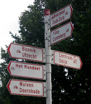
I think the lines on [1] are merely a guideline for cyclists what the
recommended route from the suburbs to the city center is. If they are
signposted then only by official roadsigns (like these here [2]) but
these are not cycleroutes, just as destinations for cars on roadsigns
are not carroutes.
On the OCM there are different things highlighted.
- in blue dashed lines: cycleways (highway=cycleway)
- in red (solid on zoom <= 12, opaque on zoom > 12): national (leisure)
cycleroutes
- in light blue: regional cycleroutes
- in dark blue: local cycleroutes
These are described on [3] and have specific signposts showing the
route and intermediate points.
[1]
http://bicycledutch.wordpress.com/2012/04/23/looking-down-on-cyclists/
[2] http://www.alleplaatsenopdefiets.nl/images/wegwijzer.jpg
[3]
http://wiki.openstreetmap.org/wiki/WikiProject_Nederlandse_Fietsroutes
Regards,
Maarten

_______________________________________________
talk mailing list
[email protected]
http://lists.openstreetmap.org/listinfo/talk