For those of you not following this story, Kevin Eve has been missing now over 2
weeks.   Some still think he may be stuck in a cave near his abandoned vehicle.
The note below was published by a local paper there:
They’ve ended ground searches by large groups of volunteers and
have turned to a more “site-specific”
approach, sending small teams of experienced spelunkers to scour
for hidden, alternate access points
to caves and recheck previously searched subterranean locations in the
Harrison-Crawford Forest, said Jim Hash, a conservation officer
from Harrison County.
“Cavers have a way of looking at the land differently than the rest of us.
They’re going to look for different clues,” he said.
Another article there, suggested that cavers don't have any GPS
locations recorded on lots of caves
in that area of the forest. [ I got the impression at the Indiana
NSS Convention,
that lots of cavers there knew where lots of caves were in the area,
but the problem was that there were
so many caves. ]
This message below was announced back on October 5th, but there appears to be a
new call out for experienced cave explorers to join the hunt for Kevin Eve.
In desperate need of more cavers that know the area.
There are only a few out there searching, and there are so many
caves in the area
that even the Department of Natural Resources don't know about.
If you or anyone you
know are cavers, and can assist in the search even if only for a
short time, please call
the Indiana Conservation Officers at:
812-837-9536.
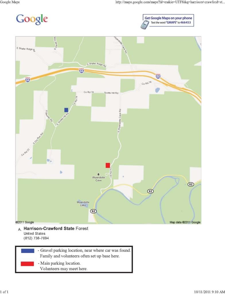
Here is a link to a map with a couple of places to meet up with other cavers:
http://i780.photobucket.com/albums/yy81/saralee1209/Kevin%20Eve%20-%20Missing%2010-1-11/GoogleMaps-Kevin2.jpg
If you look at the layout of the roads on that map, it would make
since that if he is lost in a cave, that it was near
his car. For example, there doesn't seem to be any reason to look
north of the interstate or east of Wyandotte Road,
etc.
Below are the Google map coordinates,
38.241837,-86.310031
for the approximate area where his car was found ( I have't found the
exact coordinates ).
You can click on a satellite image, and zoom in and look at the
terrain. After looking at that image, my theory is that
he walked nearly perpendicular to the road either going southeast or
northwest. Meaning drawing a circle around
the car, may not be the best way to narrow down the search. So if
it is northeast, it can't be too far, or he would have
been better off to park on Becker Road. And going southeast leads
to 4,000 feet of hiking thru forest, before he would
have been better off to park along Wyandotte Road. The coordinates
below seem like a good area to search for a small
cave entrance:
38.239132,-86.305289
based on the "guess" that he walked perpendicular to the road from the
1st coordinates above.
David Locklear
---------------------------------------------------------------------
Visit our website: http://texascavers.com
To unsubscribe, e-mail: [email protected]
For additional commands, e-mail: [email protected]