Here's what Jim Conrad posted in his Naturalist Newsletter about the
roadcut breccia that Bruce Morgan was asking about. It includes a link
to a photograph. -- Mixon
MYSTERIOUS ROADCUT
Each week when I hike to Pisté to buy fruit, on Hwy
180 between Mérida and Cancún and about half a mile
from the center of the ruins of Chichén Itzá, I pass
within ten feet of the roadcut through limestone seen
at http://www.backyardnature.net/n/10/100124rx.jpg
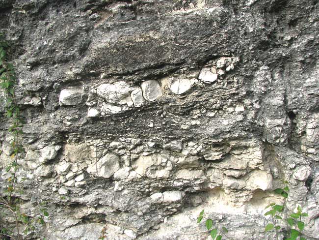
That's a vertical section of the roadcut about six
feet high. Note the weeds at the lower right for
scale.

About 65 millions years ago the entire Yucatan
Peninsula was covered by sea, as was much of the US
Southeastern Coastal Plain. At that time, at the end
of the Cretaceous Period, an object from space at
least six-miles wide (10 km) crashed into the sea at a
spot now located -- after the Yucatan Peninsula has
risen above sea level -- a few miles off the Yucatan's
northwestern coast. The crater caused by that impact,
today known as the Chicxulub Crater, was about 112
miles in diameter (180 kms). The Wikipedia page
describing the Chicxulub Crater is at
http://en.wikipedia.org/wiki/Chicxulub_crater

Long after the crater was formed, during the Oligocene
about 25 million years ago, this part of the Yucatan
Peninsula began rising, pushed upwards by forces from
within the Earth. What earlier had been the carbonate-
rich mud of the ocean floor, and limestone rock below
it lithified from that mud, gradually rose and kept
rising until today it stands above sea level, but not
by much. During those millions of years ocean currents
gradually buried the Chicxulub Crater beneath mud that
eventually hardened into limestone rock. Today if you
stand where earlier the crater was formed, you'll see
no signs of a crater at all. It's all buried beneath
limestone deposited since the impact 65 million years
ago. At Chichén Itzá we're well outside the crater's
former location, but close enough for the ocean floor
here to have been very disrupted.

The mysterious thing about the roadcut is that what
you see there suggests a great deal of turmoil.
Sediment deposited in calm, seabed conditions is
finely grained and the layering is even. The picture
shows very uneven layering, some layers tilted and
others not, and fragments of fractured rock appear to
be embedded in what once was flowing mud. Maybe
there's even a near-vertical fault cutting across the
layers at the picture's right. I've seen layering like
this in ancient mudflows beside volcanoes, but never
in limestone areas that have been as geologically
quiet as this one -- quiet since the Chicxulub Crater
was formed. In fact, I can't think of anything in the
Yucatan Peninsula's geological history that could
have created such a story of geological turmoil
as this picture suggests, except the Chicxulub Impact.

It seems that if such a wonderful exhibition of the
effects of the Chicxulub Impact were known, it'd
appear at websites dealing with the event -- would
even be an important tourist attraction. The Chicxulub
Impact, after all, is often regarded as having killed
off the dinosaurs worldwide, thus enabling mammals to
begin their evolutionary ascendancy, eventually making
possible humanity.

Is there anyone out there who can confirm that what's
in the picture is or is not evidence of the Chicxulub
Impact?
----------------------------------------
A bore is a person who talks when you wish him to listen.
----------------------------------------
You may "reply" to the address this message
came from, but for long-term use, save:
Personal: [email protected]
AMCS: [email protected] or [email protected]


---------------------------------------------------------------------
Visit our website: http://texascavers.com
To unsubscribe, e-mail: [email protected]
For additional commands, e-mail: [email protected]