Hi

This may have been discussed and resolved before, apologies if so.
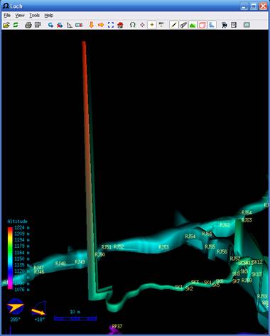
Is there a reason why loch models do this?


The passage to the left of SK1, SK2 extends about 40m beyond the survey
line, more or less horizontally, and so I have extended the plan and
elevation scraps to draw the explored, but not surveyed, passage.  (I think
the elevation scrap has no effect on the model, but I can understand the
reasons for that)

For some reason the last little bit of the 'freehand' passage model extends
up to the sky.


Is there a solution?

 I have in the past tried to use the 'point dimensions' entity in plan
scraps, but not always with success.


Thanks

bruce


-------------- next part --------------
An HTML attachment was scrubbed...
URL:
<http://mailman.speleo.sk/pipermail/therion/attachments/20090815/9420779f/attachment.html>
-------------- next part --------------
A non-text attachment was scrubbed...
Name: image002.jpg
Type: image/jpeg
Size: 18942 bytes
Desc: not available
URL:
<http://mailman.speleo.sk/pipermail/therion/attachments/20090815/9420779f/attachment.jpg>