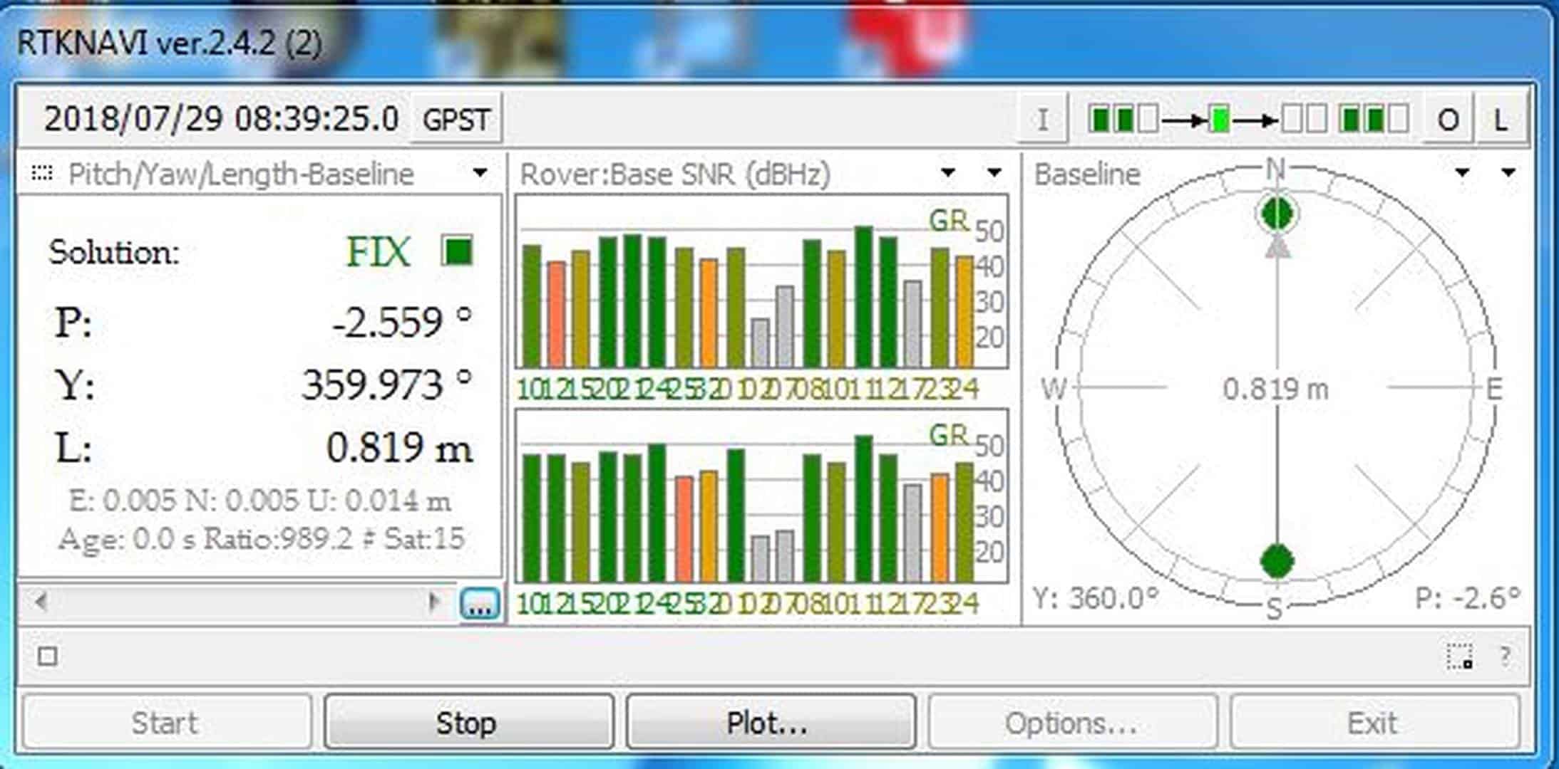
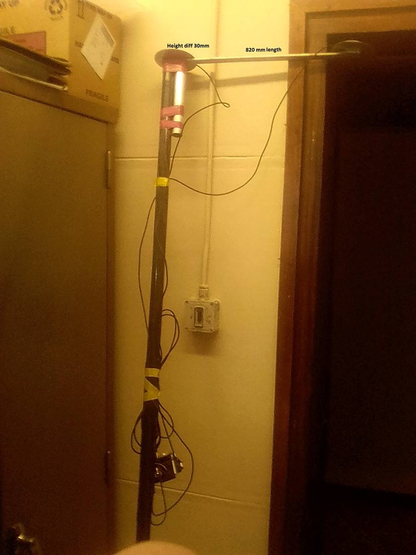
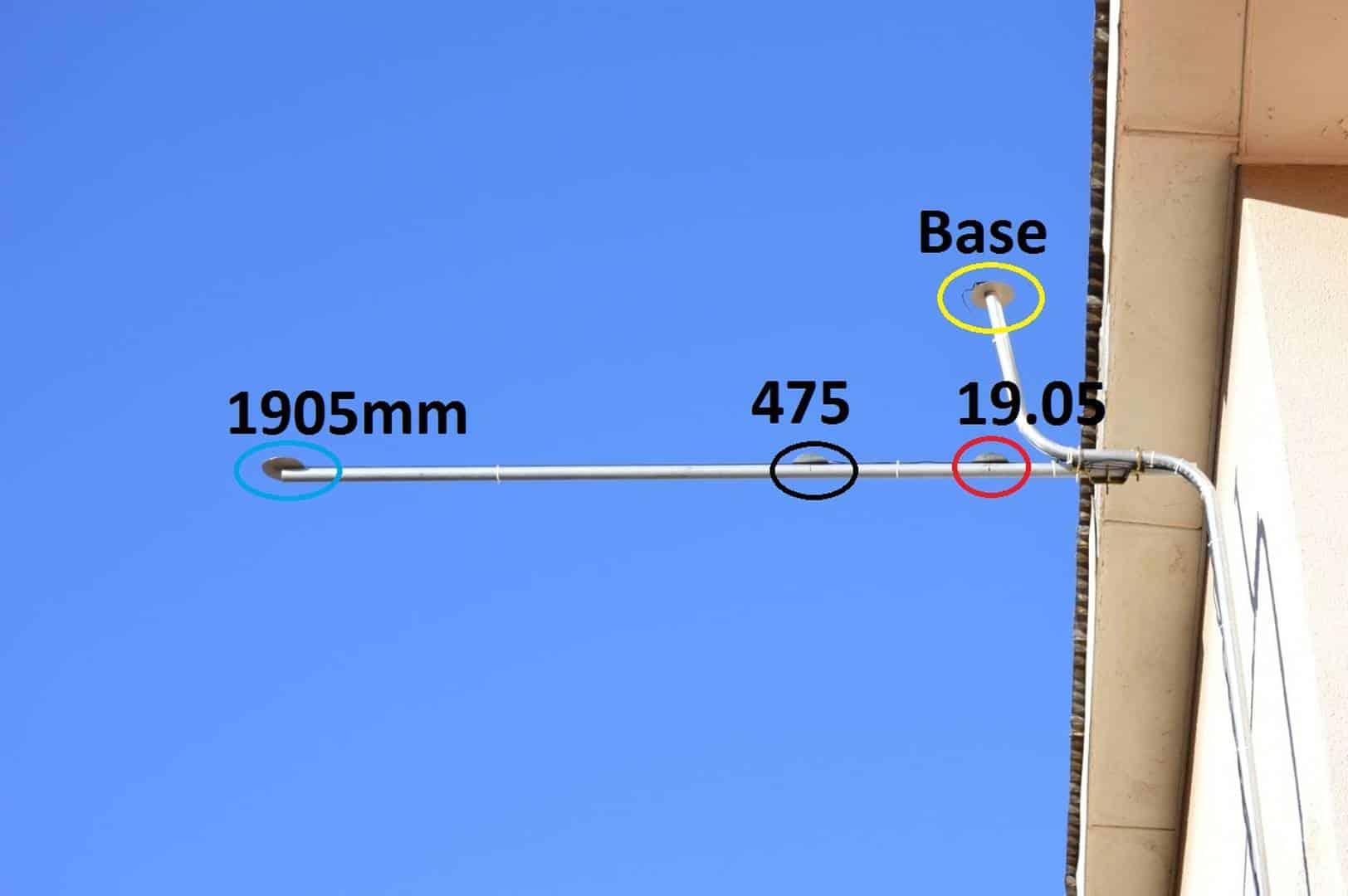
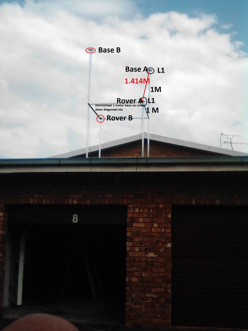
Good day Iain

What I found and what has led to the question is that doing tests with
short "baselines" below 5 meters and using a combination of Kinematic and
Moving Base RTK algorithms is that if Z is shorter or longer that X the
system will calculate the "baseline" as X. However when Z and X is equal
the system all of a sudden calculates the "baseline" as the hypotenuse. The
first image is a screen shot of the results obtained from the first rig
where the horizontal distance between the antennas was 820 mm the 3rd image
is a newer rig with antennas deployed at various distances from the Base. I
unfortunately do not have screen shots of that data set. The units all
resolved the triangles perfectly with the "baseline" the horizontal
distance value. The last image is the rig I am presently testing with where
the "baseline" now has become the hypotenuse.
The unit also when it settles down displays the correct measurement as is
the first model I built where it would indicate 820 mm between antenna
centers. The screen grab indicates 819 mm and the unit will jump a
millimeter positive or negative until it settles where it appears to be
"frozen" but responds immediately should you move the antenna.

I do not have access to the latest test equipment etc but what we have
established with this unit is that it is very precise hence the time issue.
I have been to a number of professors at the local universities but have
not been able to find anyone that can assist me in taking this forward

Thank you for your interest


Sincerely


Anton
[image: pitchyawfix]
<https://surveyorconnect.com/wp-content/uploads/wpforo/attachments/12846/11243-pitchyawfix.JPG>
[image: ToetsGps]
<https://surveyorconnect.com/wp-content/uploads/wpforo/attachments/12846/11244-ToetsGps.jpg>
[image: antenna]
<https://surveyorconnect.com/wp-content/uploads/wpforo/attachments/12846/11245-antenna.jpg>
[image: newrig]
<https://surveyorconnect.com/wp-content/uploads/wpforo/attachments/12846/11246-newrig.jpg>

On Sun, Apr 25, 2021 at 12:44 AM Iain <[email protected]> wrote:

> The angles have nothing to do with how the rtk will setup a baseline. It
> will calculate the difference in location from one point to another. The
> data collector will calculate the points and no knowledge of any angles
> unless you are using a total station
>
> > On Apr 24, 2021, at 06:34, Anton Strydom <[email protected]> wrote:
> >
> > Good day to all
> >
> > If I have a setup as per the sketch where A is either a Base or Rover
> with
> > B also being either a Base or Rover depending on A. ie if A is a Base
> the B
> > will be a Rover. X equals Z and the angle is 90 degrees.
> >
> > When doing RTK what would the Baseline be as established by the two GPS
> > units?
> >
> > Sincerely
> > Anton
> > [image: image.jpeg]
> > _______________________________________________
> > time-nuts mailing list -- [email protected] -- To unsubscribe
> send an email to [email protected]
> > To unsubscribe, go to and follow the instructions there.
> _______________________________________________
> time-nuts mailing list -- [email protected] -- To unsubscribe send
> an email to [email protected]
> To unsubscribe, go to and follow the instructions there.
_______________________________________________
time-nuts mailing list -- [email protected] -- To unsubscribe send an
email to [email protected]
To unsubscribe, go to and follow the instructions there.