Hi Tobias,
I have created the below appended gpx file.
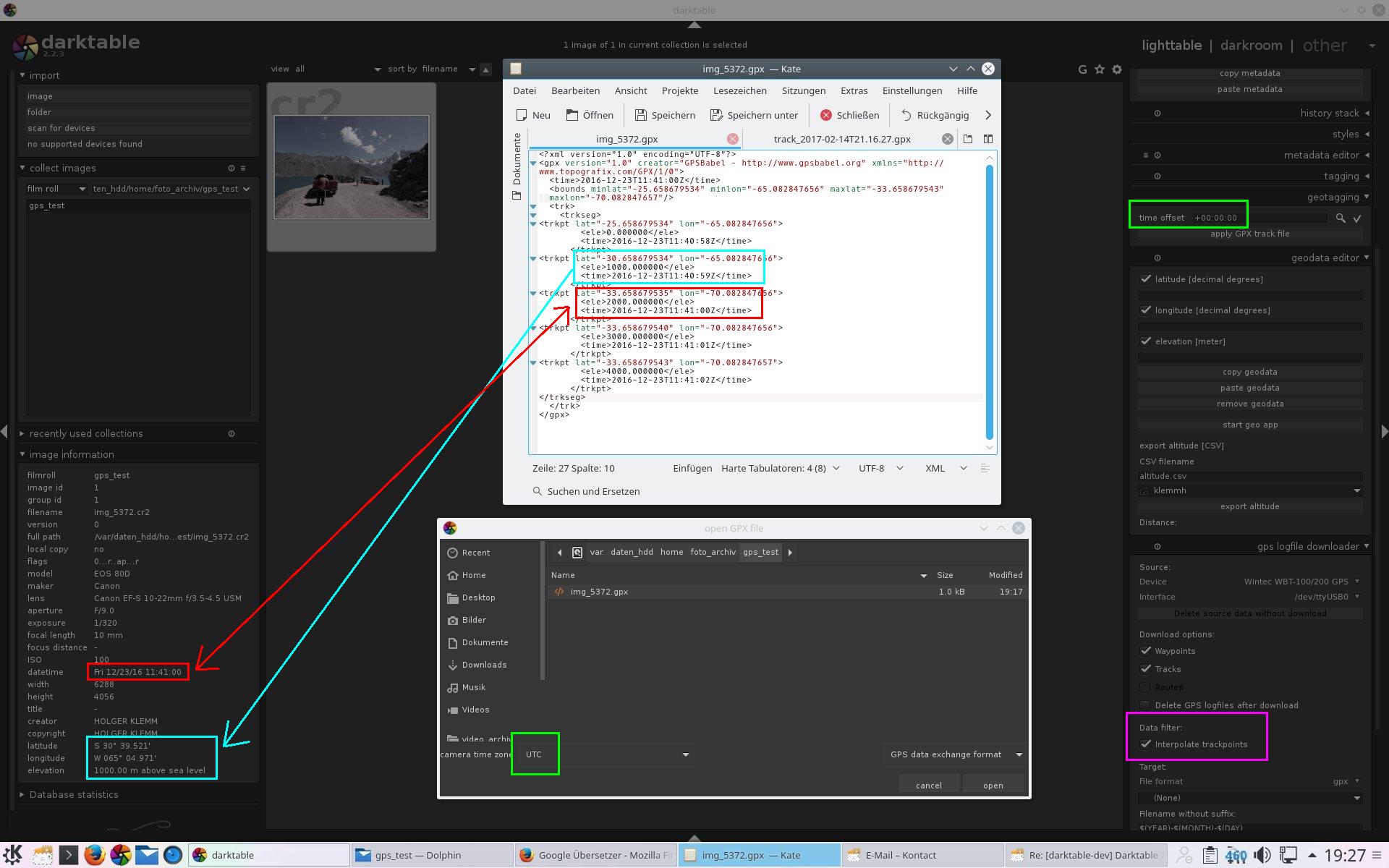
Attaching the geodata works now, but darktable attached wrong geodata. The
photo was created at 11:41:00 and the geotagging modul use the waypoint with
time 11:40:59 (time offset 00:00:00 with UTC time zone).
Here is the result:
http://www.multimedia4linux.de/dt/geotagging_gpx_with_5_points.jpg
The result is an image with elevation 1000m and not 2000m!

My darktable gps logfile downloader itself creates an interpolation, if
waypoints are missing. It would be nice, if I could switch off the interpolate
from the goetagging module.


GPX File:

<?xml version="1.0" encoding="UTF-8"?>
<gpx version="1.0" creator="GPSBabel - http://www.gpsbabel.org"; xmlns="http://
www.topografix.com/GPX/1/0">
  <time>2016-12-23T11:41:00Z</time>
  <bounds minlat="-25.658679534" minlon="-65.082847656" maxlat="-33.658679543"
maxlon="-70.082847657"/>
  <trk>
    <trkseg>
<trkpt lat="-25.658679534" lon="-65.082847656">
        <ele>0.000000</ele>
        <time>2016-12-23T11:40:58Z</time>
      </trkpt>
<trkpt lat="-30.658679534" lon="-65.082847656">
        <ele>1000.000000</ele>
        <time>2016-12-23T11:40:59Z</time>
      </trkpt>
<trkpt lat="-33.658679535" lon="-70.082847656">
        <ele>2000.000000</ele>
        <time>2016-12-23T11:41:00Z</time>
      </trkpt>
<trkpt lat="-33.658679540" lon="-70.082847656">
        <ele>3000.000000</ele>
        <time>2016-12-23T11:41:01Z</time>
      </trkpt>
<trkpt lat="-33.658679543" lon="-70.082847657">
        <ele>4000.000000</ele>
        <time>2016-12-23T11:41:02Z</time>
      </trkpt>
</trkseg>
  </trk>
</gpx>


Holger


Am Mittwoch, 15. Februar 2017, 11:01:16 CET schrieb Tobias Ellinghaus:
> Am Dienstag, 14. Februar 2017, 22:02:30 CET schrieb Holger Klemm:
> > Hi Tobias,
>
> Hi.
>
> > I use camera time zone UTC with time offset +00:00:00, but it  doesn't
> > work. I also tried other time zones. It's always the same.
> > Have a look at the picture.
> > http://www.multimedia4linux.de/dt/geotagging_timezone.jpg
>
> So, I figured out what the issue with your sample is: It only has a single
> track point in the GPX file. darktable needs at least two to interpolate
> inbetween.
>
> > If I use the log data from the last months, then my test photo is found.
> > However, the result does not fit. Time, day, place, country everything
> > wrong.
>
> That sounds like a different issue. Can you provide a sample for that, too?
>
> > Holger
>
> Tobias
>
> [...]


___________________________________________________________________________
darktable developer mailing list
to unsubscribe send a mail to [email protected]