there is business establishment I visit nearly every week, and so drive by the
Cahokia Mounds on that trip. Sometimes my daughter is with me, and we will
climb it for a bit of exercise.
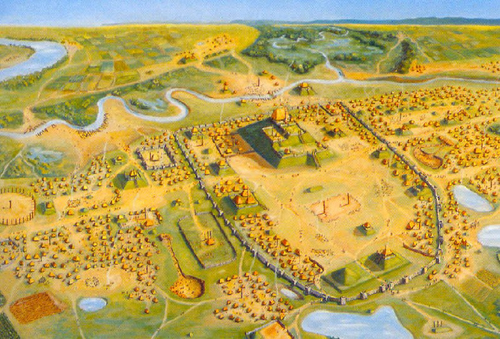
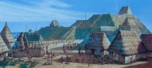
 If I go on the weekend, as the road there is populated by Hispanic eateries
and stores, I will sometimes stop and get something to eat.


 On Saturdays, there is a guy who sells trays of fresh fruit, and I always stop
and get one.


 Fresh mango, watermelon, honeydew, pineapple and some other fruits.  Those are
the fruits I get plus a few pieces of cucumber.


 I tell him I want salt, only on the cucumbers and lime juice on the rest.
Sometimes he forgets.  Yesterday it was lime juice on everything.


 What I still can't get over, is the toppings the Hispanics go for.


 Almost in every case they get cayenne pepper on the fruit, and sometimes I
think even ketchup.


 Or maybe it is a sweet syrup.


 Trying to figure that one out.


 I'm always trying to pick up some vibe when I drive by the mounds, or climb
up, but so far nothing has registered.


---In FairfieldLife@yahoogroups.com, <seerdope@...> wrote :

 Native American Cahokia Mounds Near St Louis


 http://www.legendsofamerica.com/photos-illinois/CahokiaMounds-old.jpg
http://www.legendsofamerica.com/photos-illinois/CahokiaMounds-old.jpg


 http://www.legendsofamerica.com/photos-illinois/CahokiaMounds-old.jpg

 http://www.legendsofamerica.com/photos-illinois/CahokiaM...
http://www.legendsofamerica.com/photos-illinois/CahokiaMounds-old.jpg


 View on www.legendsofameric...
http://www.legendsofamerica.com/photos-illinois/CahokiaMounds-old.jpg
 Preview by Yahoo


 Description: Cahokia was the largest and most influential urban settlement in
the Mississippian culture which developed advanced societies across much of
what is now the central and southeastern United States, beginning more than 500
years before European contact.  Cahokia was the largest urban center north of
the great Mesoamerican cities in Mexico.


 http://www.legendsofamerica.com/photos-illinois/CahokiaMounds-old.jpg
http://www.legendsofamerica.com/photos-illinois/CahokiaMounds-old.jpg


 Location: Cahokia is located on the site of a pre-Columbian Native American
city (c. 600–1400 CE) situated directly across the Mississippi River from
modern St. Louis, Missouri. The existing park covers about 3.5 square miles,
and contains about 80 mounds, but the ancient city was actually much larger.
At its peak, Cahokia covered about six square miles and included about 120
human-made earthen mounds in a wide range of sizes, shapes, and functions.


http://4.bp.blogspot.com/-aPlDR5-ZrN4/TxMnJqWmt9I/AAAAAAAAA0k/ajQ9S_Si0Xs/s1600/Cahokia-Reconst.jpg

http://4.bp.blogspot.com/-aPlDR5-ZrN4/TxMnJqWmt9I/AAAAAAAAA0k/ajQ9S_Si0Xs/s1600/Cahokia-Reconst.jpg


http://4.bp.blogspot.com/-aPlDR5-ZrN4/TxMnJqWmt9I/AAAAAAAAA0k/ajQ9S_Si0Xs/s1600/Cahokia-Reconst.jpg

 http://4.bp.blogspot.com/-aPlDR5-ZrN4/TxMnJqWmt...
http://4.bp.blogspot.com/-aPlDR5-ZrN4/TxMnJqWmt9I/AAAAAAAAA0k/ajQ9S_Si0Xs/s1600/Cahokia-Reconst.jpg


 View on 4.bp.blogspot.com
http://4.bp.blogspot.com/-aPlDR5-ZrN4/TxMnJqWmt9I/AAAAAAAAA0k/ajQ9S_Si0Xs/s1600/Cahokia-Reconst.jpg
 Preview by Yahoo


  Population:  Cahokia's population at its peak in the 1200s would not be
surpassed by any city in the United States until the late 18th century.
Although it was home to only about 1,000 people before c. 1050, its population
grew explosively after that date. Archaeologists estimate the city's population
at between 6,000 and 40,000 at its peak, with more people living in outlying
farming villages that supplied the main urban center. If the highest population
estimates are correct, Cahokia was larger than any subsequent city in the
United States until the 1780s, when Philadelphia's population grew beyond
40,000.


 Age: Although there is some evidence of Late Archaic period (approximately
1200 BCE) occupation in and around the site,[6] Cahokia as it is now defined
was settled around 1200 CE during the Late Woodland period.

 Metallurgy: 1950s by archaeologist Greg Perino found the only known copper
workshop to be found at a Mississippian site. The area contains the remains of
three tree stumps thought to have been used to hold anvil stones. Analysis of
copper found during excavations showed that it had been annealed, a technique
involving repeatedly heating and cooling the metal as it is worked, such as
blacksmiths do with iron.


 http://www.legendsofamerica.com/photos-illinois/CahokiaMoundsPast-600.jpg
http://www.legendsofamerica.com/photos-illinois/CahokiaMoundsPast-600.jpg


 http://www.legendsofamerica.com/photos-illinois/CahokiaMoundsPast-600.jpg

 http://www.legendsofamerica.com/photos-illinois/CahokiaM...
http://www.legendsofamerica.com/photos-illinois/CahokiaMoundsPast-600.jpg


 View on www.legendsofameric...
http://www.legendsofamerica.com/photos-illinois/CahokiaMoundsPast-600.jpg
 Preview by Yahoo


 Engineering: Excavation on the top of Monks Mound has revealed evidence of a
large building, likely a temple or the residence of the paramount chief, which
would have been seen throughout the city. This building was about 105 ft (32 m)
long and 48 feet (15 m) wide, and could have been as much as 50 ft (15 m) high.
It was about 5,000 sq ft (460 m2).
 A large plaza located adjacent to Monks Mound was a place where games and
public rituals took place.
 In one of the earliest large-scale construction projects, the site had been
expertly and deliberately leveled and filled by the city's inhabitants. It is
part of the sophisticated engineering displayed throughout the site. The Grand
Plaza covered roughly 50 acres (20 ha) and measured over 1,600 ft (490 m) in
length by over 900 ft (270 m) in width. Along with the Grand Plaza to the
south, three other very large plazas surround Monks Mound in the cardinal
directions to the east, west, and north. The high-status district of Cahokia
was surrounded by a long palisade that was equipped with protective bastions.
Where the palisade passed, it separated neighborhoods.  Beyond Monks Mound, as
many as 120 more mounds stood at varying distances from the city center. To
date, 109 mounds have been located, 68 of which are in the park area. The
mounds are divided into several different types: platform, conical, ridge-top,
etc.. Each appeared to have had its own meaning and function. In general terms,
the city center seems to have been laid out in a diamond-shaped pattern
approximately 1 mi (1.6 km) from end to end, while the entire city is 5 mi (8.0
km) across from east to west.


http://faculty.humanities.uci.edu/tcthorne/colonialhistory/cahokiarendition.jpg
http://faculty.humanities.uci.edu/tcthorne/colonialhistory/cahokiarendition.jpg


 http://faculty.humanities.uci.edu/tcthorne/colonialhistory/cahokiarendition.jpg

 http://faculty.humanities.uci.edu/tcthorne/colonialhisto...
http://faculty.humanities.uci.edu/tcthorne/colonialhistory/cahokiarendition.jpg


 View on faculty.humanities.uci...
http://faculty.humanities.uci.edu/tcthorne/colonialhistory/cahokiarendition.jpg
 Preview by Yahoo


 Trade Center: Cahokia became the most important center for the peoples known
today as Mississippians. Their settlements ranged across what is now the
Midwest, Eastern, and Southeastern United States. Cahokia was located in a
strategic position near the confluence of the Mississippi, Missouri andIllinois
rivers. It maintained trade links with communities as far away as the Great
Lakes to the north and the Gulf Coast to the south, trading in such exotic
items as copper, Mill Creek chert, and whelk shells.  Mill Creek chert, most
notably, was used in the production of hoes, a high demand tool for farmers
around Cahokia and other Mississippian centers. Cahokia's control of the
manufacture and distribution of these hand tools was an important economic
activity that allowed the city to thrive. Mississippian culture pottery and
stone tools in the Cahokian style were found at the Silvernale site near Red
Wing, Minnesota, and materials and trade goods from Pennsylvania, the Gulf
Coast and Lake Superior have been excavated at Cahokia.


 Astronomy: Archaeologists discovered postholes during excavation of the site
to the west of Monks Mound, revealing a timber circle. Noting that the
placement of posts marked solstices and equinoxes, they referred to it as "an
American Woodhenge", likening it to England's well-known circles at Woodhenge
and Stonehenge. Detailed analytical work supports the hypothesis that the
placement of these posts was by design. "A beaker[36] found in a pit near the
winter solstice post bore a circle and cross symbol that for many Native
Americans symbolizes the Earth and the four cardinal directions. Radiating
lines probably symbolized the sun, as they have in countless other
civilizations." The woodhenges were significant to the timing of the
agricultural cycle.


https://encrypted-tbn2.gstatic.com/images?q=tbn:ANd9GcRyT3dT0y-pAA4GUB_8g_SofUcd9y2UzdceY4RnlXNDuJZzfE_HxA

https://encrypted-tbn2.gstatic.com/images?q=tbn:ANd9GcRyT3dT0y-pAA4GUB_8g_SofUcd9y2UzdceY4RnlXNDuJZzfE_HxA


https://encrypted-tbn2.gstatic.com/images?q=tbn:ANd9GcRyT3dT0y-pAA4GUB_8g_SofUcd9y2UzdceY4RnlXNDuJZzfE_HxA

 https://encrypted-tbn2.gstatic.com/images?q...
https://encrypted-tbn2.gstatic.com/images?q=tbn:ANd9GcRyT3dT0y-pAA4GUB_8g_SofUcd9y2UzdceY4RnlXNDuJZzfE_HxA


 View on encrypted-tbn2.gstati...
https://encrypted-tbn2.gstatic.com/images?q=tbn:ANd9GcRyT3dT0y-pAA4GUB_8g_SofUcd9y2UzdceY4RnlXNDuJZzfE_HxA
 Preview by Yahoo


 Art: Artisans worked here to produce religious items, such as long-nosed god
maskettes, ceremonial earrings with a symbolic shape, thought to have been used
in fictive kinship rituals.[27][28] Many of the stylistically related
Mississippian copper plates such as the Wulfing cache from southeastern
Missouri, some of the Etowah plates from Georgia, and many of the Spiro plates
from Oklahoma are associated with the Greater Braden Style and are thought to
have been made in Cahokia in the 13th century.  archaeologists found the
remains of a man in his 40s who was probably an important Cahokian ruler. The
man was buried on a bed of more than 20,000 marine-shell disc beads arranged in
the shape of a falcon, with the bird's head appearing beneath and beside the
man's head, and its wings and tail beneath his arms and legs. The falcon
warrior or "birdman" is a common motif in Mississippian culture. In addition, a
cache of sophisticated, finely worked arrowheads in a variety of different
styles and materials was found near the grave of this important man. Separated
into four types, each from a different geographical region, the arrowheads
demonstrated Cahokia's extensive trade links in North America.

 Decline: One of the major problems that large centers like Cahokia faced was
keeping a steady supply of food, and waste disposal was also an issue, which
made Cahokia an unhealthy place. Because it was such an unhealthy place to
live, the town had to rely on social and political attractions to bring in a
steady supply of new immigrants; otherwise the town's death rate would have
caused it to be abandoned earlier. Cahokia began to decline during the twelfth
century. It was abandoned during the mid-thirteenth century. and the area
around it was largely uninhabited by indigenous tribes. Scholars have proposed
environmental factors, such as over-hunting and deforestation as explanations.
 The houses, stockade, and residential and industrial fires would have required
the annual harvesting of thousands of logs. In addition, climate change could
have aggravated effects of erosion due to deforestation, and adversely affected
the cultivation of maize, on which the community had depended.  Another
possible cause is invasion by outside peoples, though the only evidence of
warfare found so far is the wooden stockade and watchtowers that enclosed
Cahokia's main ceremonial precinct. Due to the lack of other evidence for
warfare, the palisade appears to have been more for ritual or formal separation
than for military purposes. Diseases transmitted among the large, dense urban
population are another possible cause of decline. Many recent theories propose
conquest-induced political collapse as the primary reason for Cahokia’s
abandonment.

 Sources: Cahokia - Wikipedia, the free encyclopedia
http://en.wikipedia.org/wiki/Cahokia


 http://en.wikipedia.org/wiki/Cahokia

 Cahokia - Wikipedia, the free encyclopedia
http://en.wikipedia.org/wiki/Cahokia Cahokia Mounds State Historic Site
/kəˈhoʊkiə/ (11 MS 2)[2] is located on the site of a pre-Columbian Native
American city (c. 600–1400 CE) situated directly acros...


 View on en.wikipedia.org http://en.wikipedia.org/wiki/Cahokia
 Preview by Yahoo