Hi Martin,

I saw the experimental polygons on the mapserver.  It's good to see
clipping the road against the landclass works so well.  I had played with
v.buffer before, and was going to use it as a baseline to try to retain
texture coordinates in GRASS in the same way I am for ogr-decode /
construct.  So the single road poly would still be used for clipping, but
when triangulating, I would still have individual road polys and column
data for the texture parameters.
Have you tried to triangulate the landclass in GRASS yet? I was wondering
how well that works compared to triangleJRS.
I ran a full xdist=2, ydist=2 fgfs-construct last night with my original
idea (turns out the time consumed was caused by all the converting of point
data to use clipper - reverting to GPC brings the speed back up to the
original fgfs-construct). To keep triangleJRS from crashing, I'm issuing
the -X flag (suppress exact arithmetic). The author says this isn't
recommended, and may cause artifacts, I'll have to inspect it.
http://www.cs.cmu.edu/~quake/triangle.exact.html
I want to finish my fgfs-construct rework before looking into GRASS modules
again, but I was wondering if we have documentation / sourcecode on how the
OSM data was imported / converted to shapefiles on the mapserver. I was
hoping to add a couple columns from the original XML (number of lanes /
z-order).
On Mon, Dec 19, 2011 at 7:45 AM, Martin Spott <[email protected]>wrote:
> Hi Peter,
>
> what you're describing sounds familiar. Ralf and I had been observing
> at least two characteristic types of failures:
> 1.) An airfield hole (or a road) cutting a landcover polygon into two
> parts of which the (much) smaller one was left without centroid after
> clipping.
> 2.) A centroid sitting in a very thin edge of a polygon which resulted
> from clipping at small angles, in a so-called "sliver" whereas the
> sliver was later removed (cleaned) from the polygon without relocating
> the centroid.
>
> For the long-term I'm in favour of doing all this polygon-processing in
> GRASS because GRASS takes care of the topological consistency - at
> least as long as you don't force it not to do so. In preparation of a
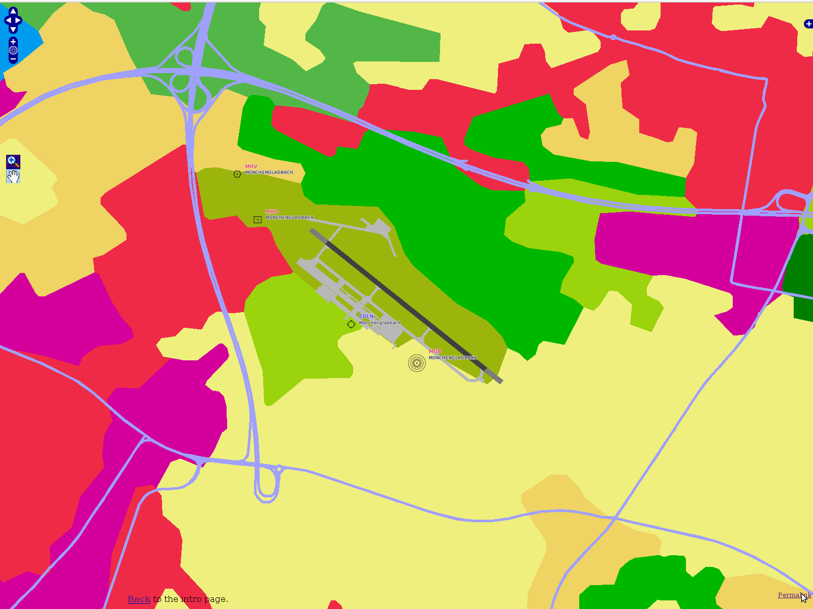
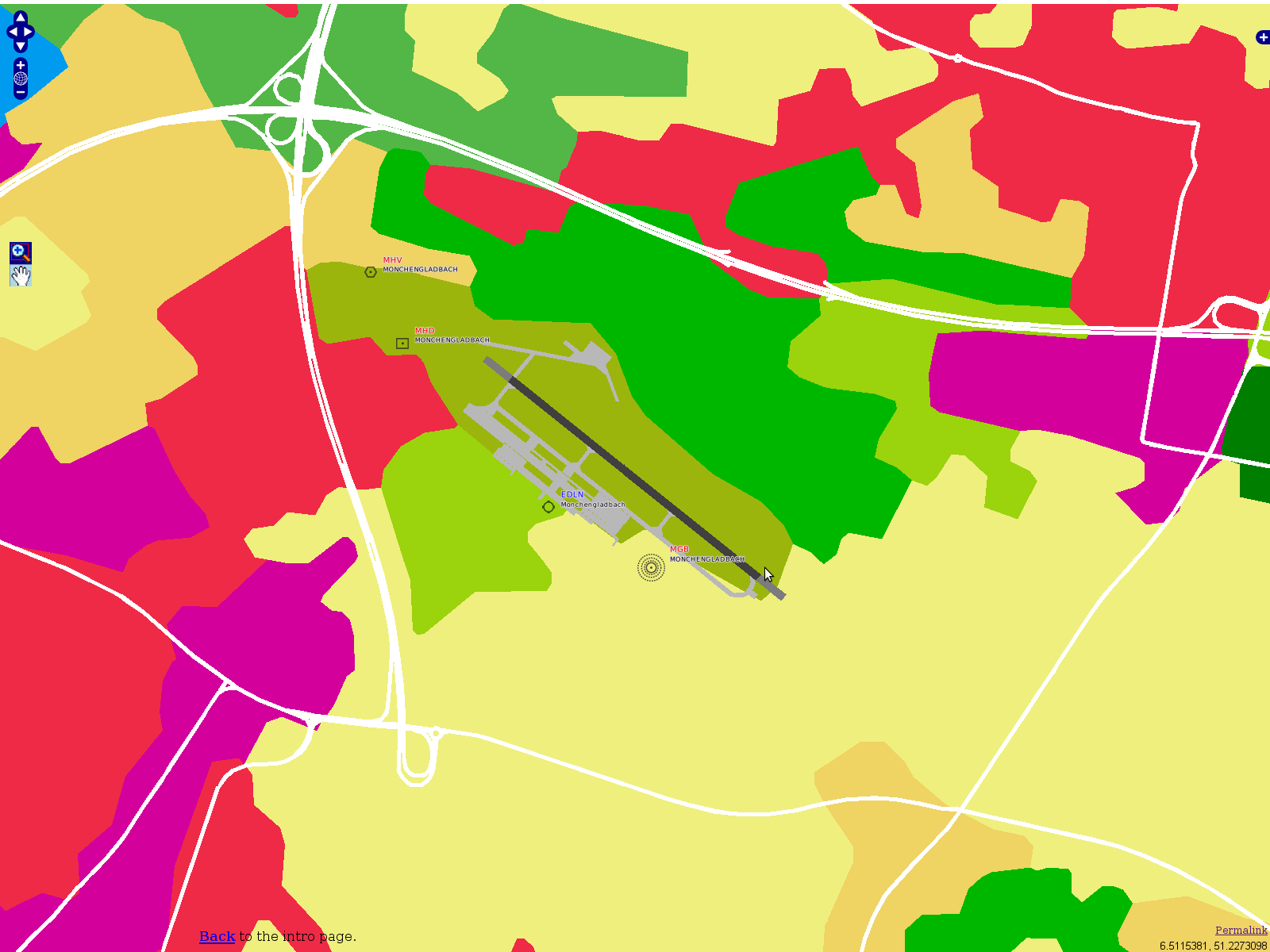
> talk last month I did a few pictures from experiments (in PostGIS and
> GRASS) by creating a buffer around all the road lines - my experimental
> OSM line feature layer on the MapServer:
>
>
> http://mapserver.flightgear.org/map/?lon=6.5045&lat=51.23036&zoom=15&layers=00000BTFFFFTFTFFFFFF
>
> This turns all the various road lines into one single polygon layer,
> ready for clipping against the land cover:
>
> http://foxtrot.mgras.net/bitmap/FGFS/EDLN-OpenLayers-RoadCover.png
>
> .... which I'm then cutting out of the landcover.
>
> http://foxtrot.mgras.net/bitmap/FGFS/EDLN-OpenLayers-RoadCutout.png
>
> Images had been rendered via MapServer right from the PostGIS DB and
> delivered by OpenLayers. The underlying principle is very simple,
> indeed. Anyhow I'm still impressed that all this really works as
> advertized on real data ;-)
>
> Currently I'm (hopefully) running the last test-cycles for cleaning
> polygonal land cover at large scale in GRASS. Next step will be to
> verify wether "v.drape" yields a result which is suitable for our
> needs, thus by filling airport holes (via "poly2ogr" and some vertex
> elevation magic) and roads into the base land cover, just few steps
> remain until the stuff could be written into <your favourite scenery
> format>.
>
> Cheers,
> Martin.
> --
> Unix _IS_ user friendly - it's just selective about who its friends are !
> --------------------------------------------------------------------------
>
>
> ------------------------------------------------------------------------------
> Learn Windows Azure Live! Tuesday, Dec 13, 2011
> Microsoft is holding a special Learn Windows Azure training event for
> developers. It will provide a great way to learn Windows Azure and what it
> provides. You can attend the event by watching it streamed LIVE online.
> Learn more at http://p.sf.net/sfu/ms-windowsazure
> _______________________________________________
> Flightgear-devel mailing list
> [email protected]
> https://lists.sourceforge.net/lists/listinfo/flightgear-devel
>
------------------------------------------------------------------------------
Learn Windows Azure Live!  Tuesday, Dec 13, 2011
Microsoft is holding a special Learn Windows Azure training event for
developers. It will provide a great way to learn Windows Azure and what it
provides. You can attend the event by watching it streamed LIVE online.
Learn more at http://p.sf.net/sfu/ms-windowsazure
_______________________________________________
Flightgear-devel mailing list
[email protected]
https://lists.sourceforge.net/lists/listinfo/flightgear-devel