Hi GeoTools people,

I have a pipeline for data from geostationary satellites which involves the
following:
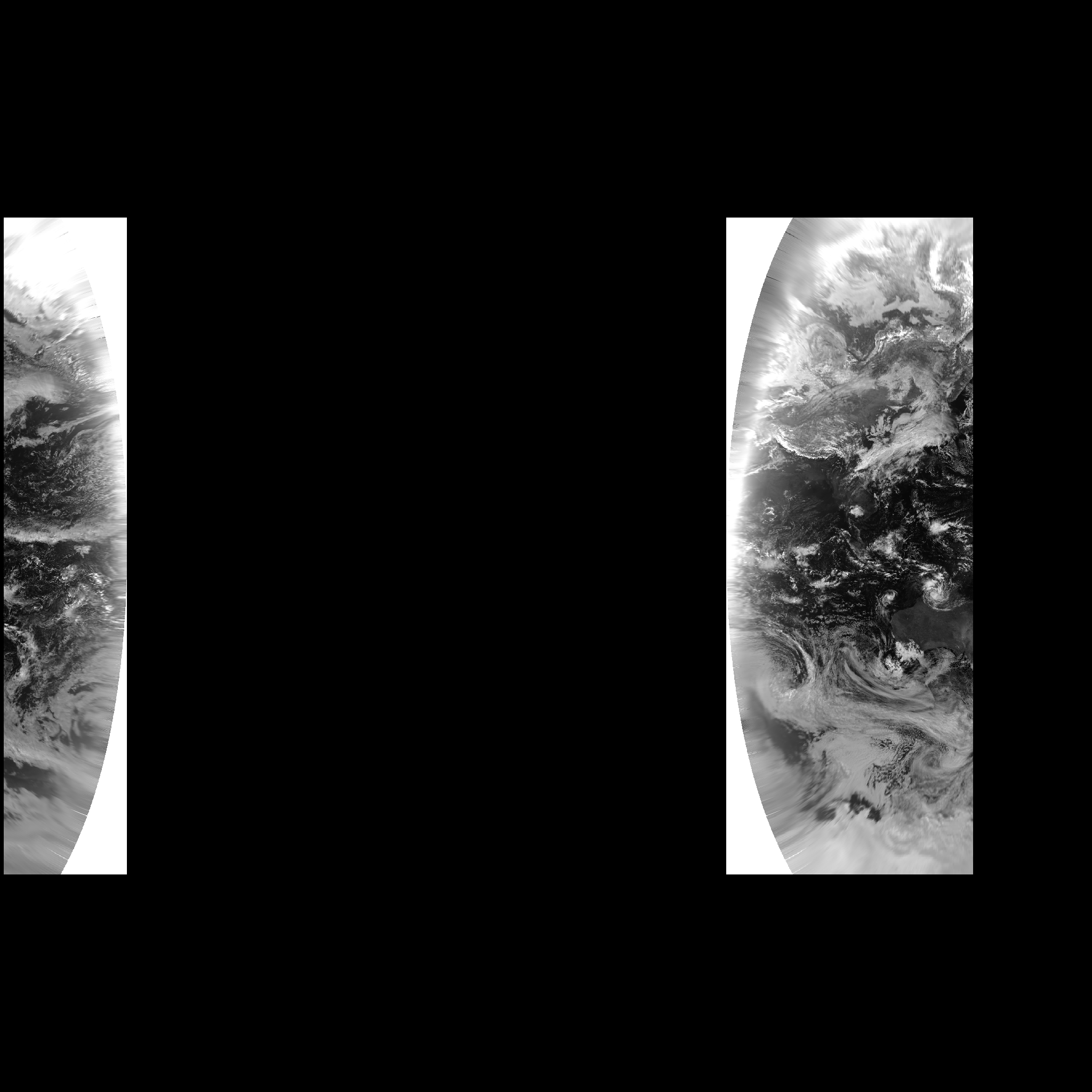
   - use GDAL to reproject the data from its native, geostationary
   projection to a cylindrical projection
   - use GDAL to arrange the data into a cloud optimised GeoTIFF
   - use a GeoTools based server to render imagery from the COG to clients

The reason for reprojecting is that I've never been able to get GeoTools to
transform from the geostationary projections.

A basic geographic projection is fine in cases where the satellite is
centred nearer to 0°E but when its field of view encompasses the dateline
it's helpful to use an equidistant cylindrical projection that's centred on
the same longitude as the satellite. That avoids dealing with an image
which spans from 180°W to 180°E and comprises mostly "nodata" pixels (with
the data at the left and right edges).

When rendering the latter images using GeoTools, though, I get a band of
missing data near the dateline. I'm wondering whether anybody can see where
I'm going wrong.

To reproduce:

The following is an image produced from Himawari-8's visible red band, in
the native geostationary projection.
https://anero.id/geotools-202003/himawari-8-visible.tif

Here it is after reprojecting to +proj=eqc +lon_0=140.7 +ellps=WGS84 using
GDAL.
https://anero.id/geotools-202003/himawari-8-visible-eqc.tif

And here's the image from GeoTools, rendered using the code below. Note the
band of missing data between about 140°E (the central meridian of the
projection?) and the 180°E (the right hand side of the image).
https://anero.id/geotools-202003/geotools-web-mercator.png

public void test(File in /* himawari-8-visible-eqc.tif */, File out
/* geotools-web-mercator.png */) {
    AbstractGridFormat format = GridFormatFinder.findFormat(in);
    AbstractGridCoverage2DReader reader = format.getReader(in);

    Layer rasterLayer = new GridReaderLayer(reader,

SLD.wrapSymbolizers(CommonFactoryFinder.getStyleFactory().getDefaultRasterSymbolizer()));

    MapContent mapContent = new MapContent();
    mapContent.addLayer(rasterLayer);

    StreamingRenderer renderer = new StreamingRenderer();
    //Map<Object, Object> rendererParams = new HashMap<>();
    //rendererParams.put(StreamingRenderer.CONTINUOUS_MAP_WRAPPING,
Boolean.TRUE);
    //renderer.setRendererHints(rendererParams); // had no effect
    renderer.setMapContent(mapContent);

    BufferedImage image = new BufferedImage(2048, 2048,
BufferedImage.TYPE_INT_RGB);
    try {
        renderer.paint(image.createGraphics(),
                new Rectangle(image.getWidth(), image.getHeight()),
                new ReferencedEnvelope(
                        -20026376.39, 20026376.39, -20026376.39,
20026376.39, CRS.decode("EPSG:3857")));

        ImageIO.write(image, "png", out);
    } catch (Exception e) {
        e.printStackTrace();
    }
}

Many thanks in advance for any help.

Regards,

Andrew
_______________________________________________
GeoTools-GT2-Users mailing list
GeoTools-GT2-Users@lists.sourceforge.net
https://lists.sourceforge.net/lists/listinfo/geotools-gt2-users