The bug report is at https://osgeo-org.atlassian.net/browse/GEOT-6547.
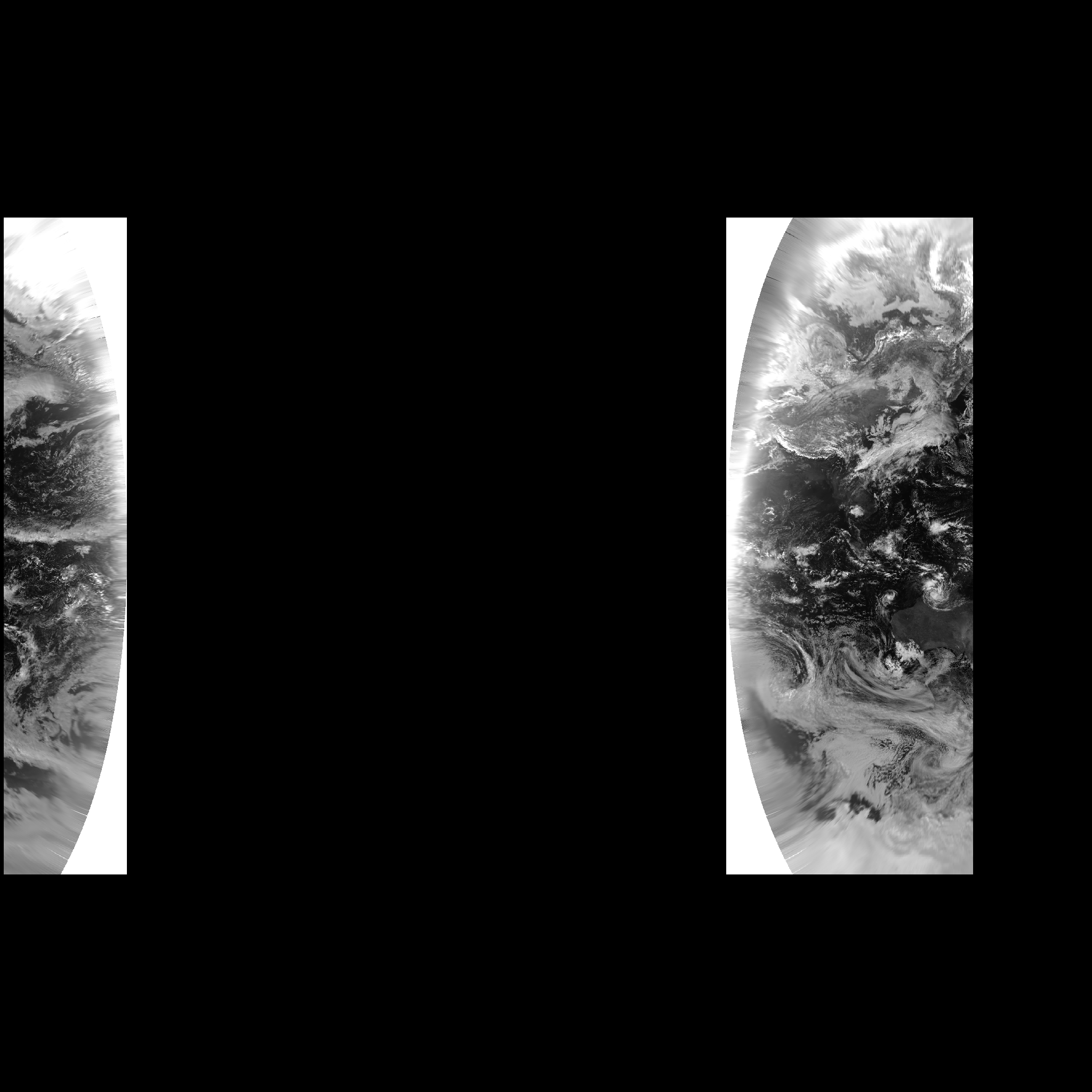
Andrew

On Tue, 14 Apr 2020 at 03:34, Jody Garnett <jody.garn...@gmail.com> wrote:

> Please don't assume you have done something wrong, that is always a clue
> that you have found a problem or the documentation needs help (which is a
> also a chance to contribute).
>
> I will keep a look out for your bug report, ideally you could get this in
> before tomorrows level meeting.
> --
> Jody Garnett
>
>
> On Wed, 8 Apr 2020 at 16:56, Andrew Miskelly <amiske...@weatherzone.com.au>
> wrote:
>
>> Hi Jody,
>>
>> In answer to your subsequent questions:
>>
>> - I haven't created a bug report yet as I've been assuming that I'm doing
>> something wrong. I'm happy to create an issue outlining the process that I
>> included at the top of the thread. Once done, I'll mention it here.
>>
>> - Enabling advanced projection handing results in a "Bursa wolf
>> parameters required" error.
>>
>> The projection is based on "+proj=eqc +lat_ts=0 +lat_0=0 +lon_0=140.7
>> +x_0=0 +y_0=0 +ellps=WGS84 +units=m" and I enabled advanced projection
>> handling via the StreamingRenderer's hints.
>>
>> ...
>> StreamingRenderer renderer = new StreamingRenderer();
>> Map<Object, Object> rendererParams = new HashMap<>();
>> rendererParams.put(StreamingRenderer.ADVANCED_PROJECTION_HANDLING_KEY,
>> Boolean.TRUE);
>> renderer.setRendererHints(rendererParams);
>> ...
>>
>> org.opengis.referencing.operation.OperationNotFoundException: Bursa wolf
>> parameters required.
>> at
>> org.geotools.referencing.operation.DefaultCoordinateOperationFactory.createOperationStep(DefaultCoordinateOperationFactory.java:1220)
>> at
>> org.geotools.referencing.operation.DefaultCoordinateOperationFactory.createOperationStep(DefaultCoordinateOperationFactory.java:1281)
>> at
>> org.geotools.referencing.operation.DefaultCoordinateOperationFactory.createOperationStep(DefaultCoordinateOperationFactory.java:922)
>> at
>> org.geotools.referencing.operation.DefaultCoordinateOperationFactory.findOperationSteps(DefaultCoordinateOperationFactory.java:1006)
>> at
>> org.geotools.referencing.operation.DefaultCoordinateOperationFactory.findOperations(DefaultCoordinateOperationFactory.java:341)
>> at
>> org.geotools.referencing.operation.DefaultCoordinateOperationFactory.createOperation(DefaultCoordinateOperationFactory.java:206)
>> at
>> org.geotools.referencing.operation.BufferedCoordinateOperationFactory.createOperation(BufferedCoordinateOperationFactory.java:233)
>> at org.geotools.referencing.CRS.findMathTransform(CRS.java:1266)
>> at org.geotools.referencing.CRS.findMathTransform(CRS.java:1234)
>> at
>> org.geotools.coverage.grid.io.ReadResolutionCalculator.<init>(ReadResolutionCalculator.java:91)
>> at
>> org.geotools.renderer.lite.gridcoverage2d.GridCoverageReaderHelper.computeReadingGeometry(GridCoverageReaderHelper.java:500)
>> at
>> org.geotools.renderer.lite.gridcoverage2d.GridCoverageReaderHelper.readCoverageInEnvelope(GridCoverageReaderHelper.java:363)
>> at
>> org.geotools.renderer.lite.gridcoverage2d.GridCoverageReaderHelper.readCoverages(GridCoverageReaderHelper.java:247)
>> at
>> org.geotools.renderer.lite.gridcoverage2d.GridCoverageRenderer.renderImage(GridCoverageRenderer.java:690)
>> at
>> org.geotools.renderer.lite.gridcoverage2d.GridCoverageRenderer.paint(GridCoverageRenderer.java:897)
>> at
>> org.geotools.renderer.lite.StreamingRenderer$RenderCoverageReaderRequest.execute(StreamingRenderer.java:3880)
>> at
>> org.geotools.renderer.lite.StreamingRenderer$PainterThread.run(StreamingRenderer.java:3991)
>> at
>> java.base/java.util.concurrent.Executors$RunnableAdapter.call(Executors.java:515)
>> at java.base/java.util.concurrent.FutureTask.run(FutureTask.java:264)
>> at
>> java.base/java.util.concurrent.ThreadPoolExecutor.runWorker(ThreadPoolExecutor.java:1128)
>> at
>> java.base/java.util.concurrent.ThreadPoolExecutor$Worker.run(ThreadPoolExecutor.java:628)
>> at java.base/java.lang.Thread.run(Thread.java:830)
>>
>> Andrew
>>
>> On Thu, 9 Apr 2020 at 09:54, Andrew Miskelly <
>> amiske...@weatherzone.com.au> wrote:
>>
>>> Yes, sorry about that. My reply to your previous email follows, without
>>> the inline images, and I'll reply again to address your most recent email.
>>>
>>> No, I haven't managed to solve this.
>>>
>>> I wasn't using JAI-EXT but a static call to JAIExt.initJAIEXT() in the
>>> test class has not changed the results. (I'm also using 23-RC, in order to
>>> assist with the testing effort.)
>>>
>>> The starting image, in +proj=eqc +lon_0=140.7 +ellps=WGS84, looks like
>>> the following (Australia in the middle longitudes; ±180° about 3/4 across
>>> from the left):
>>> https://anero.id/geotools-202003/himawari-8-visible-eqc.tif
>>>
>>> When I reproject to a full world web mercator tile using GeoTools, and
>>> the test case outlined earlier, I get a gap between 140.7°E and 180°E (i.e.
>>> the right hand side):
>>> https://anero.id/geotools-202003/geotools-web-mercator.png
>>>
>>> Regards,
>>>
>>> Andrew
>>>
>>> On Tue, 7 Apr 2020 at 04:22, Jody Garnett <jody.garn...@gmail.com>
>>> wrote:
>>>
>>>> I love seeing your test data, although I expect that only went to me as
>>>> the mailing list blocks emails past a specific size.
>>>>
>>>> Next I have a couple obvious questions:
>>>>
>>>> - I have not looked yet, did you reported this as a bug to the issue
>>>> tracker,  having a test case (and test data) very much helps reproduce the
>>>> issue.
>>>> - Have you enabled advanced reprojection handling
>>>> <https://docs.geotools.org/latest/userguide/faq.html#q-what-about-raster-advanced-projection-handling>
>>>> (which is specially for this kind of problem)
>>>>
>>>> I am not familiar with this specific area of the code; but I am
>>>> interested in learning the resolution.
>>>>
>>>> --
>>>> Jody Garnett
>>>>
>>>>
>>>> On Thu, 2 Apr 2020 at 15:59, Andrew Miskelly <
>>>> amiske...@weatherzone.com.au> wrote:
>>>>
>>>>> Hi Jody,
>>>>>
>>>>> No, I haven't managed to solve this.
>>>>>
>>>>> I wasn't using JAI-EXT but a static call to JAIExt.initJAIEXT() in
>>>>> the test class has not changed the results. (I'm also using 23-RC, in
>>>>> order
>>>>> to assist with the testing effort.)
>>>>>
>>>>> The starting image, in +proj=eqc +lon_0=140.7 +ellps=WGS84, looks
>>>>> like the following (Australia in the middle longitudes; ±180° about 3/4
>>>>> across from the left):
>>>>>
>>>>> When I reproject to a full world web mercator tile using GeoTools, and
>>>>> the test case outlined earlier, I get a gap between 140.7°E and 180°E
>>>>> (i.e.
>>>>> the right hand side):
>>>>>
>>>>> Regards,
>>>>>
>>>>> Andrew
>>>>>
>>>>>
>>>>> On Fri, 3 Apr 2020 at 05:51, Jody Garnett <jody.garn...@gmail.com>
>>>>> wrote:
>>>>>
>>>>>> I was curious if you resolved this issue? Some care has been taken
>>>>>> with JAI-EXT operations to better handle no data etc... can you confirm
>>>>>> your system is setup to use these operations?
>>>>>> JAI itself has some ideas for extending the border area to prevent
>>>>>> artifacts near edges ideally a solution would hook into this.
>>>>>> --
>>>>>> Jody Garnett
>>>>>>
>>>>>>
>>>>>> On Mon, 16 Mar 2020 at 21:13, Andrew Miskelly <
>>>>>> amiske...@weatherzone.com.au> wrote:
>>>>>>
>>>>>>> Hi GeoTools people,
>>>>>>>
>>>>>>> I have a pipeline for data from geostationary satellites which
>>>>>>> involves the following:
>>>>>>>
>>>>>>>    - use GDAL to reproject the data from its native, geostationary
>>>>>>>    projection to a cylindrical projection
>>>>>>>    - use GDAL to arrange the data into a cloud optimised GeoTIFF
>>>>>>>    - use a GeoTools based server to render imagery from the COG to
>>>>>>>    clients
>>>>>>>
>>>>>>> The reason for reprojecting is that I've never been able to get
>>>>>>> GeoTools to transform from the geostationary projections.
>>>>>>>
>>>>>>> A basic geographic projection is fine in cases where the satellite
>>>>>>> is centred nearer to 0°E but when its field of view encompasses the
>>>>>>> dateline it's helpful to use an equidistant cylindrical projection
>>>>>>> that's
>>>>>>> centred on the same longitude as the satellite. That avoids dealing
>>>>>>> with an
>>>>>>> image which spans from 180°W to 180°E and comprises mostly "nodata"
>>>>>>> pixels
>>>>>>> (with the data at the left and right edges).
>>>>>>>
>>>>>>> When rendering the latter images using GeoTools, though, I get a
>>>>>>> band of missing data near the dateline. I'm wondering whether anybody
>>>>>>> can
>>>>>>> see where I'm going wrong.
>>>>>>>
>>>>>>> To reproduce:
>>>>>>>
>>>>>>> The following is an image produced from Himawari-8's visible red
>>>>>>> band, in the native geostationary projection.
>>>>>>> https://anero.id/geotools-202003/himawari-8-visible.tif
>>>>>>>
>>>>>>> Here it is after reprojecting to +proj=eqc +lon_0=140.7 +ellps=WGS84
>>>>>>> using GDAL.
>>>>>>> https://anero.id/geotools-202003/himawari-8-visible-eqc.tif
>>>>>>>
>>>>>>> And here's the image from GeoTools, rendered using the code below.
>>>>>>> Note the band of missing data between about 140°E (the central meridian
>>>>>>> of
>>>>>>> the projection?) and the 180°E (the right hand side of the image).
>>>>>>> https://anero.id/geotools-202003/geotools-web-mercator.png
>>>>>>>
>>>>>>> public void test(File in /* himawari-8-visible-eqc.tif */, File out
>>>>>>> /* geotools-web-mercator.png */) {
>>>>>>>     AbstractGridFormat format = GridFormatFinder.findFormat(in);
>>>>>>>     AbstractGridCoverage2DReader reader = format.getReader(in);
>>>>>>>
>>>>>>>     Layer rasterLayer = new GridReaderLayer(reader,
>>>>>>>
>>>>>>> SLD.wrapSymbolizers(CommonFactoryFinder.getStyleFactory().getDefaultRasterSymbolizer()));
>>>>>>>
>>>>>>>     MapContent mapContent = new MapContent();
>>>>>>>     mapContent.addLayer(rasterLayer);
>>>>>>>
>>>>>>>     StreamingRenderer renderer = new StreamingRenderer();
>>>>>>>     //Map<Object, Object> rendererParams = new HashMap<>();
>>>>>>>     //rendererParams.put(StreamingRenderer.CONTINUOUS_MAP_WRAPPING,
>>>>>>> Boolean.TRUE);
>>>>>>>     //renderer.setRendererHints(rendererParams); // had no effect
>>>>>>>     renderer.setMapContent(mapContent);
>>>>>>>
>>>>>>>     BufferedImage image = new BufferedImage(2048, 2048,
>>>>>>> BufferedImage.TYPE_INT_RGB);
>>>>>>>     try {
>>>>>>>         renderer.paint(image.createGraphics(),
>>>>>>>                 new Rectangle(image.getWidth(), image.getHeight()),
>>>>>>>                 new ReferencedEnvelope(
>>>>>>>                         -20026376.39, 20026376.39, -20026376.39,
>>>>>>> 20026376.39, CRS.decode("EPSG:3857")));
>>>>>>>
>>>>>>>         ImageIO.write(image, "png", out);
>>>>>>>     } catch (Exception e) {
>>>>>>>         e.printStackTrace();
>>>>>>>     }
>>>>>>> }
>>>>>>>
>>>>>>> Many thanks in advance for any help.
>>>>>>>
>>>>>>> Regards,
>>>>>>>
>>>>>>> Andrew
>>>>>>>
>>>>>>> _______________________________________________
>>>>>>> GeoTools-GT2-Users mailing list
>>>>>>> GeoTools-GT2-Users@lists.sourceforge.net
>>>>>>> https://lists.sourceforge.net/lists/listinfo/geotools-gt2-users
>>>>>>
>>>>>>
>>
_______________________________________________
GeoTools-GT2-Users mailing list
GeoTools-GT2-Users@lists.sourceforge.net
https://lists.sourceforge.net/lists/listinfo/geotools-gt2-users