Hi Helena,

Thanks for your reply.
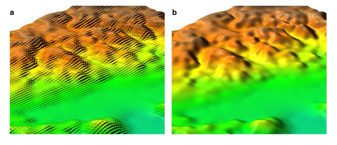
>just a few notes. If you set the resolution to 20m, GRASS will resample
your 90m SRTM to 20m using nearest neighbor, creating a DEM with "steps" -
something line this (a) is automatic nn resampling, b) is reinterpolation by
rst) http://www.grassbook.org/gallery/chapters/s050303f010_resamp.jpg

Yes, yesterday I tried the described procedure and I noticed the same result
NVIZing the reprojected dem. BTW I don't need to produce 3D maps, but I need
to introduce the less data distorsion as possible. The NN method should do
the job for me. I'm not sure that an interpolation would be a good solution,
but I talk with a strict mathematic/electronic approach, that's my
professional training; probably, talking about topography, interpolations
rarely produce remarkable errors.

This said, I prefer the 20m data, against the SRTM ones, because I analyzed
a very well known (small) area with NVIZ, using both SRTM and 20m data, and
I noticed relevant errors with SRTM data (I cannot pretend much from it,
it's a SAR shuttle mission... it's actually a miracle that we have it, that
it works pretty fine and that is free).

Summarizing:
1) r.proj method=nearest
2) r.resamp.rst

Right?

Thanks,

Marco


-----Messaggio originale-----
Da: Helena Mitasova [mailto:[EMAIL PROTECTED]
Inviato: mercoledì 7 maggio 2008 18.25
A: [EMAIL PROTECTED]
Oggetto: Re: [GRASS-dev] Reproject, change resolution and patch: doubts....


Marko,

just a few notes. If you set the resolution to 20m, GRASS will resample your
90m SRTM to 20m using nearest neighbor, creating a DEM with "steps" -
something line this (a) is automatic nn resampling, b) is reinterpolation by
rst) http://www.grassbook.org/gallery/chapters/s050303f010_resamp.jpg
Dylan has a nice comparison of effects of different resampling and
reinterpolation  methods on his web site, if you want to learn more.

If you have a GRASS book and the nc_spm data set - it has both SRTM data and
lidar based 10m and 1m resolution DEMs so you can see how SRTM works, there
are several examples in the book - e.g. SRTM is consistently higher and I
did viewshed from 30m SRTM and lidar-based 30m DEM - same resolution but the
results were quite different. You need to keep in mind that SRTM maps the
surface with vegetation on it while your 20m DEM is probably bare earth
surface. Also look at the metadata for both to compare their vertical
accuracy, some smoothing of SRTM may actually be justified (unless you want
the vegetation and have some means to add it to your 20m DEM). When you
decide to reinterpolate you can compare your re-interpolated DEM with the
original data (e.g. the 90m grid centers) and make sure that any smoothing
does not exceed the accuracy of your original data.

Just for illustration: here is a stream network derived from 10m resolution
IFSARE patched with 90m SRTM where IFSARE data were missing, all
reinterpolated to 30m resolution to get the river flow seamlessly
back-and-forth along the patch line.
http://skagit.meas.ncsu.edu/~helena/measwork/panama/pacora30maccum.jpg
some SRTM data can be pretty noisy:
http://skagit.meas.ncsu.edu/~helena/measwork/nrc/mumbai_srtm.png

Helena
>
> Do you agree?
>
> Thanks for all,
>
> Marco
> _______________________________________________
> grass-dev mailing list
> [email protected]
> http://lists.osgeo.org/mailman/listinfo/grass-dev

_______________________________________________
grass-dev mailing list
[email protected]
http://lists.osgeo.org/mailman/listinfo/grass-dev