Hi Helena,

> 1) r.proj method=nearest

good, the basic step has been fixed :-)

> 2) r.resamp.rst
>- you don't need this step if the default nearest neighbor works for
>your application
>  - it is useful only if you needed smooth connection between the 20m
>DEM and SRTM. ( r.resamp.rst does interpolation using a spline
>function - you can make it pass exactly through the given data points
>by setting smoothing =0.)
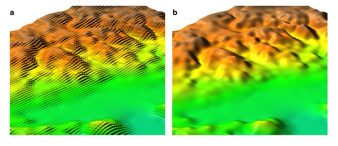
Actually I already thought that, in any case, I should at least fix the
interferences among the two different maps. That means that I should at least
apply r.resamp.rst along the line where the two maps collide. Having the 20m
raster called, for example, 20mDEM, I figured out (and already tested) how to
create a polygon matching the exact boudaries of that map (exactly an area
vector layer matching the whole area covered by the 20mDEM map):

create a raster from 20mDEM with NULL if NULL and 0 if >=0
transform that raster into a vector layer faeaturing the area covered by it

r.mapcalc 20mDEM_surface='if(20mDEM,0)'
r.to.vect feauture=area

Then I could apply r.resamp.rst on a buffer along the polyline that describe
the border of the above area... but I'm not sure how to do that, I still need
to carefully read the online manuals (unfortunately I still don't have the book
of Markus; GFOSS.it association kindly gave me a copy... but I still have to
get it...)

Thanks,

Marco


________________________________

Da: Helena Mitasova [mailto:[EMAIL PROTECTED]
Inviato: gio 08/05/2008 2.46
A: [EMAIL PROTECTED]
Oggetto: Re: R: [GRASS-dev] Reproject, change resolution and patch: doubts....


On May 7, 2008, at 3:35 PM, Marco Pasetti wrote:

> Hi Helena,
>
> Thanks for your reply.
>
>> just a few notes. If you set the resolution to 20m, GRASS will
>> resample
> your 90m SRTM to 20m using nearest neighbor, creating a DEM with
> "steps" -
> something line this (a) is automatic nn resampling, b) is
> reinterpolation by
> rst) http://www.grassbook.org/gallery/chapters/s050303f010_resamp.jpg
>
> Yes, yesterday I tried the described procedure and I noticed the
> same result
> NVIZing the reprojected dem. BTW I don't need to produce 3D maps,
> but I need
> to introduce the less data distorsion as possible. The NN method
> should do
> the job for me. I'm not sure that an interpolation would be a good
> solution,
> but I talk with a strict mathematic/electronic approach, that's my
> professional training; probably, talking about topography,
> interpolations
> rarely produce remarkable errors.
>
> This said, I prefer the 20m data, against the SRTM ones, because I
> analyzed
> a very well known (small) area with NVIZ, using both SRTM and 20m
> data, and
> I noticed relevant errors with SRTM data (I cannot pretend much
> from it,
> it's a SAR shuttle mission... it's actually a miracle that we have
> it, that
> it works pretty fine and that is free).
>
> Summarizing:
> 1) r.proj method=nearest

> 2) r.resamp.rst

- you don't need this step if the default nearest neighbor works for
your application
  - it is useful only if you needed smooth connection between the 20m
DEM and SRTM. ( r.resamp.rst does interpolation using a spline
function - you can make it pass exactly through the given data points
by setting smoothing =0.)

Helena


>
>
> Right?
>
> Thanks,
>
> Marco
>
>
>
> -----Messaggio originale-----
> Da: Helena Mitasova [mailto:[EMAIL PROTECTED]
> Inviato: mercoledì 7 maggio 2008 18.25
> A: [EMAIL PROTECTED]
> Oggetto: Re: [GRASS-dev] Reproject, change resolution and patch:
> doubts....
>
>
> Marko,
>
> just a few notes. If you set the resolution to 20m, GRASS will
> resample your
> 90m SRTM to 20m using nearest neighbor, creating a DEM with "steps" -
> something line this (a) is automatic nn resampling, b) is
> reinterpolation by
> rst) http://www.grassbook.org/gallery/chapters/s050303f010_resamp.jpg
> Dylan has a nice comparison of effects of different resampling and
> reinterpolation  methods on his web site, if you want to learn more.
>
> If you have a GRASS book and the nc_spm data set - it has both SRTM
> data and
> lidar based 10m and 1m resolution DEMs so you can see how SRTM
> works, there
> are several examples in the book - e.g. SRTM is consistently higher
> and I
> did viewshed from 30m SRTM and lidar-based 30m DEM - same
> resolution but the
> results were quite different. You need to keep in mind that SRTM
> maps the
> surface with vegetation on it while your 20m DEM is probably bare
> earth
> surface. Also look at the metadata for both to compare their vertical
> accuracy, some smoothing of SRTM may actually be justified (unless
> you want
> the vegetation and have some means to add it to your 20m DEM). When
> you
> decide to reinterpolate you can compare your re-interpolated DEM
> with the
> original data (e.g. the 90m grid centers) and make sure that any
> smoothing
> does not exceed the accuracy of your original data.
>
> Just for illustration: here is a stream network derived from 10m
> resolution
> IFSARE patched with 90m SRTM where IFSARE data were missing, all
> reinterpolated to 30m resolution to get the river flow seamlessly
> back-and-forth along the patch line.
> http://skagit.meas.ncsu.edu/~helena/measwork/panama/pacora30maccum.jpg
> some SRTM data can be pretty noisy:
> http://skagit.meas.ncsu.edu/~helena/measwork/nrc/mumbai_srtm.png
>
> Helena
>>
>> Do you agree?
>>
>> Thanks for all,
>>
>> Marco
>> _______________________________________________
>> grass-dev mailing list
>> [email protected]
>> http://lists.osgeo.org/mailman/listinfo/grass-dev
>
_______________________________________________
grass-dev mailing list
[email protected]
http://lists.osgeo.org/mailman/listinfo/grass-dev