Carrie,

Our trick is to wrap on a character that you would otherwise not normally see
in the string.
LAYER
....
CLASS
TEXT ([LastName] * [PIN]) #overrides LABELITEM
.....
LABEL
WRAP "*"
END #Parcel Label
END #Parcel Class
END #Parcel Layer
Sincerely,
Mark Volz, GISP
-----Original Message-----
From: mapserver-users [mailto:[email protected]] On
Behalf Of [email protected]
Sent: Wednesday, June 29, 2016 11:04 AM
To: [email protected]
Subject: mapserver-users Digest, Vol 101, Issue 37
Send mapserver-users mailing list submissions to
[email protected]
To subscribe or unsubscribe via the World Wide Web, visit
http://lists.osgeo.org/mailman/listinfo/mapserver-users
or, via email, send a message with subject or body 'help' to
[email protected]
You can reach the person managing the list at
[email protected]
When replying, please edit your Subject line so it is more specific than "Re:
Contents of mapserver-users digest..."
Today's Topics:
1. Map file, Label WRAP Function in mapbook removes character it
is wrapping on. (Carrie Quast)
----------------------------------------------------------------------
Message: 1
Date: Wed, 29 Jun 2016 15:58:59 +0000
From: Carrie Quast <[email protected]>
To: "'[email protected]'"
<[email protected]>
Subject: [mapserver-users] Map file, Label WRAP Function in mapbook
removes character it is wrapping on.
Message-ID: <[email protected]>
Content-Type: text/plain; charset="utf-8"
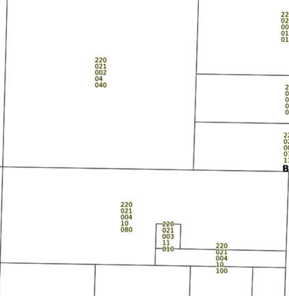
Hello - I'm working on updating my .MAP Documents to Mapserver 7.0.1.
I'm trying to get the labels in my Parcel Layer to wrap on the decimal point
(example 002.001.001.01.010) to make for a better a fit. I'm using the WRAP
function, which works wonderfully , except it removes the character I am
wrapping on. In this case, the point (.) In my parcel numbers.
Each of the numbers should have a decimal between it. Any idea of how to get
the line to wrap on a character, but also keep it in the displayed label? The
MAXLENGTH works well too, but still removes all decimal points.
I'm using Mapserver 7.0.1 with GeoMoose 2.9
Thank You - Carrie Quast, Brown County MN GIS Specialist
[cid:[email protected]]
-------------- next part --------------
An HTML attachment was scrubbed...
URL:
<http://lists.osgeo.org/pipermail/mapserver-users/attachments/20160629/8bda4b92/attachment.html>
-------------- next part --------------
A non-text attachment was scrubbed...
Name: image001.png
Type: image/png
Size: 66665 bytes
Desc: image001.png
URL:
<http://lists.osgeo.org/pipermail/mapserver-users/attachments/20160629/8bda4b92/attachment.png>
-------------- next part --------------
A non-text attachment was scrubbed...
Name: image002.png
Type: image/png
Size: 31355 bytes
Desc: image002.png
URL:
<http://lists.osgeo.org/pipermail/mapserver-users/attachments/20160629/8bda4b92/attachment-0001.png>
------------------------------
Subject: Digest Footer
_______________________________________________
mapserver-users mailing list
[email protected]
http://lists.osgeo.org/mailman/listinfo/mapserver-users
------------------------------
End of mapserver-users Digest, Vol 101, Issue 37
************************************************
_______________________________________________
mapserver-users mailing list
[email protected]
http://lists.osgeo.org/mailman/listinfo/mapserver-users