On Wed, Aug 10, 2011 at 11:48 PM, <[email protected]> wrote:
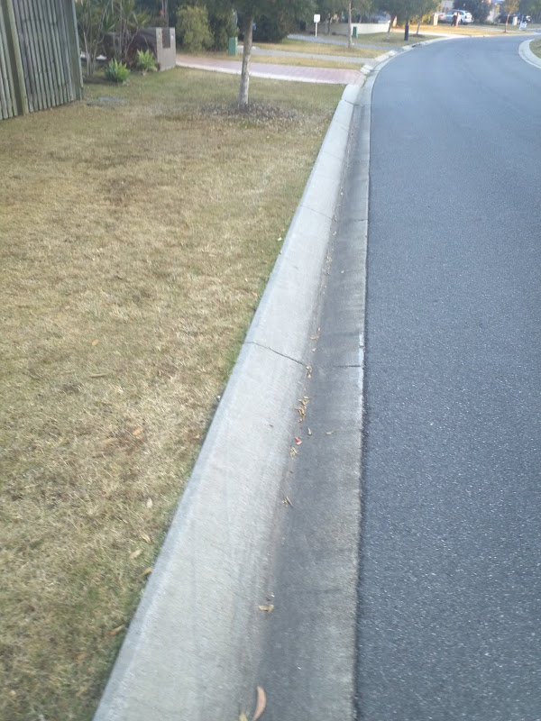
> I assume that if I have a way that runs along the physical location of the
> kerb (e.g. because it's a closed way or part of a multi-poly that's used to
> define a landuse area) I could tag that way with kerb= to indicate the type
> of kerb?
>

I believe that to be an acceptable method. However where footways/paths
cross the kerb, you should also add a kerb=* tag to the intersection node,
because it's asking a lot of data consumers to check every intersecting way
for the kerb=* tag.


> In that case, how should the type of kerb shown in this image be tagged?
>
>
> https://lh4.googleusercontent.com/-ZazzZqW8w5U/TkNH_duXp5I/AAAAAAAAAEs/kwDNJFxO9BE/s800/IMG_20110806_170811.jpg
>

>From the picture it appears to be kerb=rolled, that is "traversable by
vehicles and bicycles, but not wheelchairs".


> How should a stormwater drain be tagged?
>
>
> https://lh5.googleusercontent.com/-gD6RfYExBTc/TkNNqT-MNuI/AAAAAAAAAFI/gqh2ROwDkNQ/s800/IMG_20110811_132316.jpg
>

You could use kerb=normal (a value being discussed) to indicate it is not
accessible to vehicles (car/bike/wheelchair). Since I can't find a tag for
stormwater drains, perhaps just add a note (or propose a new tag :). I'd say
it should be tagged both as a kerb and a stormwater drain.


> And how should the place where a footpath crosses onto the road be tagged?
>
>
> https://lh3.googleusercontent.com/-ML8g03AXppA/TkNO5KLLIeI/AAAAAAAAAFY/O42YukZE_EY/s800/IMG_20110811_132337.jpg
>
>
This would be kerb=dropped (being discussed to replace the kerb=lowered
value), as it is accessible to bikes/wheelchairs.

-Josh
_______________________________________________
Tagging mailing list
[email protected]
http://lists.openstreetmap.org/listinfo/tagging