I had a chance to look at these 4 examples of small artificial
waterways used for irrigation or drinking water and lined with stone
or concrete, suggested to be tagged as <waterway?>=aqueduct
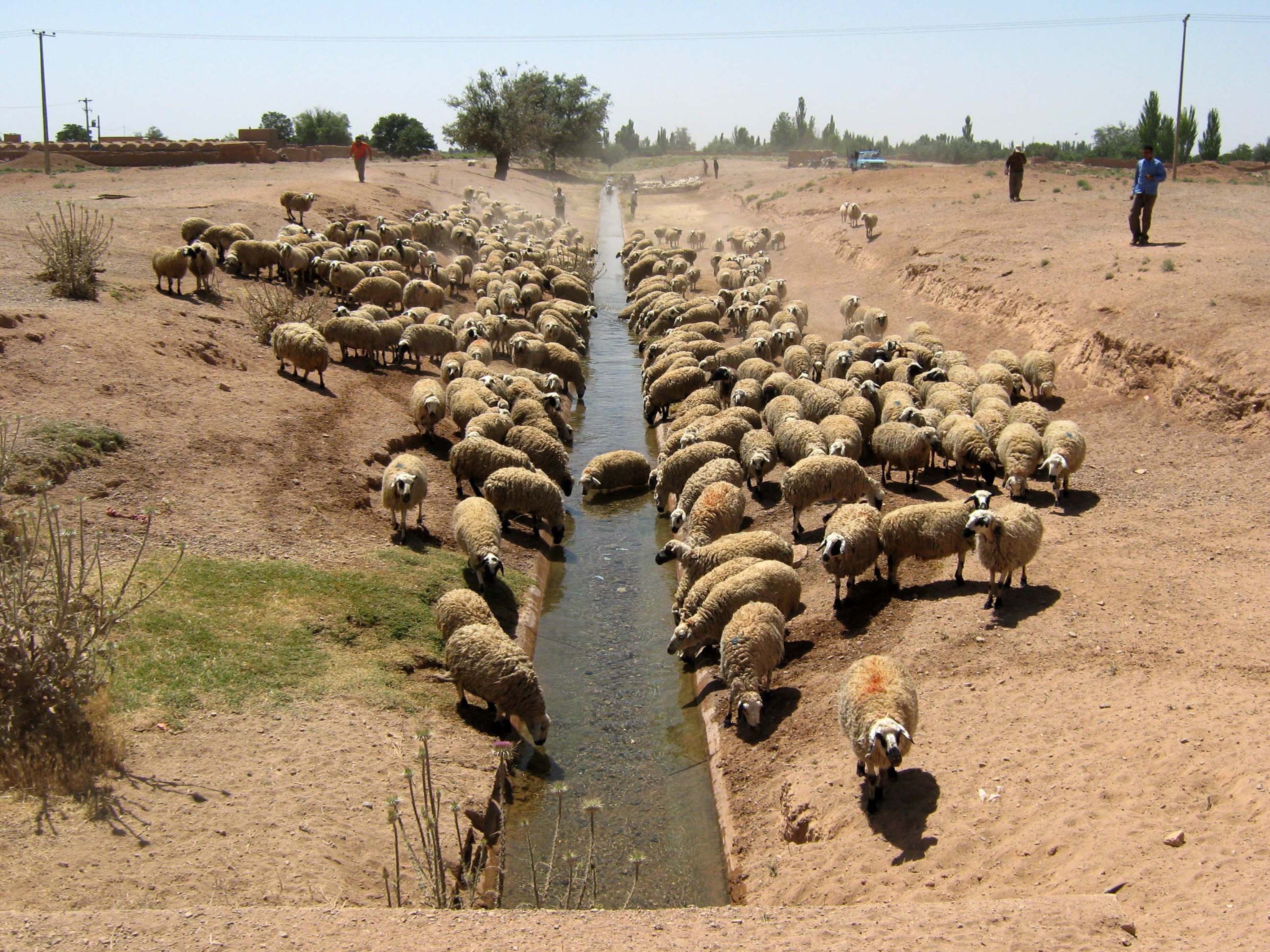
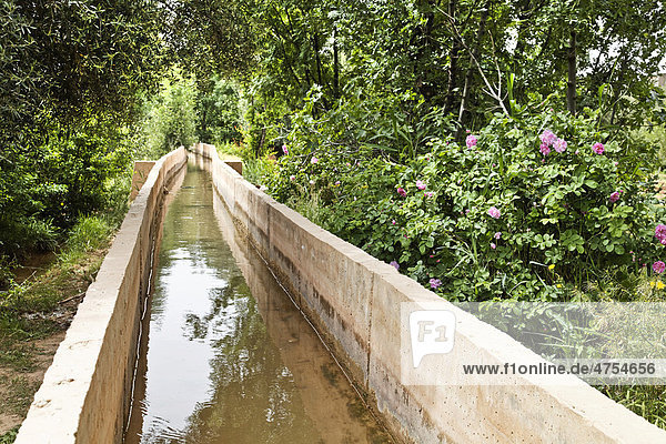
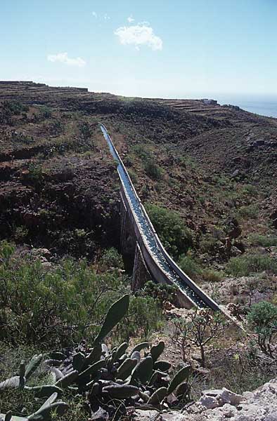
1) This is a shallow, straight waterway about 1 meter wide, which is
the bottom of a wider depression, in a semi-arid region. The bottom is
curved, but lined with concrete perhaps, and it's being used to water
sheep. This might be called a "canal" based on construction, or maybe
a "drain" - although I don't know the context, so I can't see if this
is mainly irrigation water or mainly drainage.

I don't think "aqueduct" would work, since it isn't above ground level:
https://assets.weforum.org/editor/skgMAyNg8Xu_anqQbTcTo87HkYgWEiN0eF-5dlsLhCo.jpg


2) This waterway looks to be about 1 to 1.5 meters wide. It's profile
is square, and the bottom appears to be at ground level and it's
probably concrete while the sides are concrete walls which rise up
about 0.5 to 1 meter above ground level. I can't tell if it's used for
irrigation or for drainage, but I suspect it's for irrigation.

I agree that this is probably best described as an "aqueduct":
http://www0.f1online.de/preW/004754000/4754656.jpg

3) A narrow waterway with stone or concrete walls on each side, in an
arid region. In the middle it is elevated on a viaduct (or bridge)
over a gully. This is probably an aqueduct used to supply drinking
water and irrigation water: >
http://www.insel-teneriffa.de/bilder-images/wasserversorgung-teneriffa-tf00_1474.jpg

4) A levada; a small channel (less than 1 meter wide and 1 meter high)
along a hillside, lined with a wall on the lower side and perhaps a
small stone retaining wall on the uphill side:
https://en.wikipedia.org/wiki/Levada "A levada is an irrigation
channel or aqueduct specific to the Portuguese Atlantic region of
Madeira."
I agree that waterway=aqueduct could be a good description for this
https://c7.alamy.com/compde/eetk3t/levada-bewasserungskanal-und-wanderweg-in-der-nahe-von-rabacal-madeira-eetk3t.jpg

The tag historic=aqueduct is already in use for historic features,
such as old roman aqueducts, which may no longer be in use, and
bridge=aqueduct is used for any viaduct or bridge that carries a
waterway above ground level, including aqueducts, irrigations canals,
and navigable canals.

It looks like waterway=aqueduct could be used for waterways that are
generally built with an above-ground structure on one or both sides,
such as stone, brickwork, concrete walls or even wood walls. This
would also include flumes and sluices. They could also be covered, but
are not a man_made=pipeline. Generally such structures are usually
narrower than a large canal, though there would be some overlap, and
are used to supply useful water, rather than to drain it like a
waterway=drain.

Most modern aqueducts used to supply water to cities in developed
countries are constructed from pipelines now, but it appears that
these older styles of aqueducts are still common in places where they
were built before the development of modern pipelines, or where local
labor and materials are still much cheaper than imported pipe
sections.

- Joseph

On 5/29/19, Martin Koppenhoefer <[email protected]> wrote:
>
>
> sent from a phone
>
>> On 29. May 2019, at 12:53, Joseph Eisenberg <[email protected]>
>> wrote:
>>
>> If there are small irrigation waterways that area lined with stone (or
>> concrete etc), we probably need a new tag, since waterway=drain is
>> pretty strongly associated with drainage, not irrigation, and
>> waterway=canal probably has a minimum width?
>
>
> examples
> https://assets.weforum.org/editor/skgMAyNg8Xu_anqQbTcTo87HkYgWEiN0eF-5dlsLhCo.jpg
> http://www0.f1online.de/preW/004754000/4754656.jpg
> http://www.insel-teneriffa.de/bilder-images/wasserversorgung-teneriffa-tf00_1474.jpg
> https://c7.alamy.com/compde/eetk3t/levada-bewasserungskanal-und-wanderweg-in-der-nahe-von-rabacal-madeira-eetk3t.jpg
>
> maybe these could be called aqueducts?
>
>
> Cheers, Martin

_______________________________________________
Tagging mailing list
[email protected]
https://lists.openstreetmap.org/listinfo/tagging