Hello,

I'm looking for a way to tag designated areas where cyclists wait to
safely make a far turn (in right-hand-drive regions, a left turn).
I'll call them "left turn boxes" for short though pointers to a better
name would be welcome!
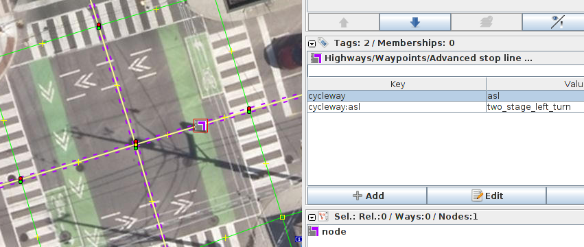
They're paint-designated places for cyclists to wait to do a two-stage
left turn from the right edge of the roadway. In regions that allow
right turn on red traffic signal, they are usually coupled with
no-right-turn-on-red restrictions. See for example
https://bin.piorkowski.ca/2019/two_stage_left_turn.png - screenshot of
Esri imagery for https://osm.org/node/25813496 at
43.6670781,-79.3746698

To my understanding, this is not the same as a cycleway=asl (advanced
stop line, "bike box") in OSM as an ASL is _behind_ the stop line and
behind the pedestrian crossing, and thus not really easily usable for
left turns - cyclists would have to cross the stream of pedestrians to
get into the box.

I am aware that in many regions left turn boxes are common to the
point of being basically the default at bigger intersections, and thus
doesn't really need tagging. However, the area I'm mapping has
probably a single digit amount of them. As they make left turns a lot
safer, I would like to map them so that routers can prefer them.

Does anyone know of an established way to tag these that I could adopt?

To tag unambiguously and in a computer-readable way, I guess it'll
need a relation from-to-via?

Previously discussed in OSM Canada Slack, #general channel on October
16, 2019
https://osm-ca.slack.com/archives/C36U69X18/p1571266663002600?thread_ts=1571265183.002300&cid=C36U69X18
but we didn't come up with much. Looking for an alternatives to a
relation, I came up with
https://bin.piorkowski.ca/2019/possible_asl_node_tagging.png and
described it as following: "I suppose something like this could work
to avoid a relation, routers would then have to look for
cycleway:asl=two_stage_left_turn a little to the right of where they'd
like to make a left turn. Advantages: no relations - they seem to be
somewhat disliked in OSM; representation as turn-right-then-U-turn is
somewhat like how cyclists are used to turning left at hostile
intersections. Disadvantages: the portrayed distance to turn off to
right is further than the actual distance; routers might well find it
easier to find left turns as they would normally and then prioritize
those with a bicycle_two_stage_left_turn relation"

But frankly I don't really like that solution much, and the other
editor contributing in the Slack thread thought it would be
"misleading, since the box is on a way not actually involved in the
turn".

Thanks for any leads!

--Jarek

_______________________________________________
Tagging mailing list
[email protected]
https://lists.openstreetmap.org/listinfo/tagging