Hello,

Just a bump here to see if anyone has opinions about tagging for
infrastructure allowing for two-stage bicycle turns. Please see
original message quoted below for more details.
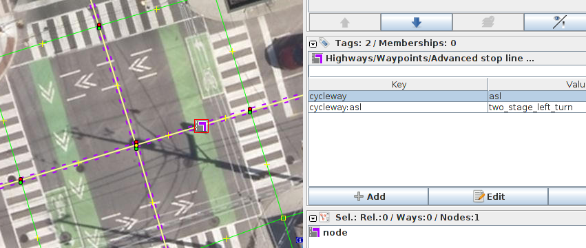
I'm currently thinking of using the following:

- relation with tag type=bicycle_two_stage_turn (comments on this
particularly welcome! it doesn't really seem to be a route=bicycle
since it doesn't have a designated network=*?)
- optionally segregated=yes if there is a designated, separated
waiting area for the bikes rather than only a painted area that is
also driven over by other vehicles (would usually be at particularly
wide intersections or at T-intersections)
- members as in a turn restriction relation: `from` and `to` ways, and
`via` either node or way

Comments most welcome!

If there are no comments here, I suppose I will create a tagging
proposal on wiki in a couple of days.

Thanks,
--Jarek

On Mon, 16 Dec 2019 at 20:05, Jarek Piórkowski <[email protected]> wrote:
>
> Hello,
>
> I'm looking for a way to tag designated areas where cyclists wait to
> safely make a far turn (in right-hand-drive regions, a left turn).
> I'll call them "left turn boxes" for short though pointers to a better
> name would be welcome!
>
> They're paint-designated places for cyclists to wait to do a two-stage
> left turn from the right edge of the roadway. In regions that allow
> right turn on red traffic signal, they are usually coupled with
> no-right-turn-on-red restrictions. See for example
> https://bin.piorkowski.ca/2019/two_stage_left_turn.png - screenshot of
> Esri imagery for https://osm.org/node/25813496 at
> 43.6670781,-79.3746698
>
> To my understanding, this is not the same as a cycleway=asl (advanced
> stop line, "bike box") in OSM as an ASL is _behind_ the stop line and
> behind the pedestrian crossing, and thus not really easily usable for
> left turns - cyclists would have to cross the stream of pedestrians to
> get into the box.
>
> I am aware that in many regions left turn boxes are common to the
> point of being basically the default at bigger intersections, and thus
> doesn't really need tagging. However, the area I'm mapping has
> probably a single digit amount of them. As they make left turns a lot
> safer, I would like to map them so that routers can prefer them.
>
> Does anyone know of an established way to tag these that I could adopt?
>
> To tag unambiguously and in a computer-readable way, I guess it'll
> need a relation from-to-via?
>
> Previously discussed in OSM Canada Slack, #general channel on October
> 16, 2019
> https://osm-ca.slack.com/archives/C36U69X18/p1571266663002600?thread_ts=1571265183.002300&cid=C36U69X18
> but we didn't come up with much. Looking for an alternatives to a
> relation, I came up with
> https://bin.piorkowski.ca/2019/possible_asl_node_tagging.png and
> described it as following: "I suppose something like this could work
> to avoid a relation, routers would then have to look for
> cycleway:asl=two_stage_left_turn a little to the right of where they'd
> like to make a left turn. Advantages: no relations - they seem to be
> somewhat disliked in OSM; representation as turn-right-then-U-turn is
> somewhat like how cyclists are used to turning left at hostile
> intersections. Disadvantages: the portrayed distance to turn off to
> right is further than the actual distance; routers might well find it
> easier to find left turns as they would normally and then prioritize
> those with a bicycle_two_stage_left_turn relation"
>
> But frankly I don't really like that solution much, and the other
> editor contributing in the Slack thread thought it would be
> "misleading, since the box is on a way not actually involved in the
> turn".
>
> Thanks for any leads!
>
> --Jarek

_______________________________________________
Tagging mailing list
[email protected]
https://lists.openstreetmap.org/listinfo/tagging