On 21/2/22 19:51, cleary wrote:
I too have struggled with correct tagging. I live in the city but I have
enjoyed visiting western NSW and I have an interest in the waterways of the
Murray-Darling river system. I have seen areas temporarily flooded on some
occasions and the same areas dust-dry at other times. I think I am probably the
person who mapped Lake Leaghur, among  others but not Mungo.  I have also
mapped areas including up to Ivanhoe, so I may have been the person mapping
other areas that Warin has mentioned.
One of the issues is the frequency of water in the rivers and lakes.
Quite some time ago I proposed the key 'ephemeral' as being less frequent then
'intermittent' .. but then other suggestions came up and I put it on 'the
backburner'..
I recently add a time limit on the water presence to the proposal. I think that
puts it out of 'usefulness' for European mappers and may lead to its rejection,
if they cannot use it they don't like it.
I am inclined to add the tag 'ephemeral=yes' to much of Australia inland water
things.
I recall the indigenous rangers at Lake Mungo saying that the Lake has not been
covered with water for about 15,000 years (when the Lachlan River forged a new
course and a much reduced volume now flows down what we know as Willandra
Creek).  I am not certain but I think none of the lakes of the Willandra Lake
region has been seriously submerged for many many years. Water flowing into the
lakes can make them soggy but not enough that one might contemplate using a
boat. I know NSW DCS Map shows the lakes as water but I recall a national parks
officer telling me that every year people arrive with their boats based on what
they see on maps but are disappointed as there is never enough water even to
swim, much less launch a boat.
The default OSM render does at least show 'intermittent'. I was not aware of
the 15,000 years, perhaps forgotten, makes water=lake be very wrong!
From the above I am incline to simply map them as sand areas with any relevant
names, and perhaps 'was:natural=water' with 'comment=water 15,000 years ago'.
?? Any objections? OSM is supposed to map the now not the history.
As I remember 'Lake Mungo' it had no suggestion of being a 'wetland' there
being nothing I could see that would suggest the plant growth I'd associate
with any wet area,
so I'd be reluctant to use the tag wetland. There is an area tagged with some
'protected zone' to the west of Lake Mungo .. that on hte DCS map (I don't
recall which) has some small areas with 'dry' wetland  mapped.

Dry wetland out here to me means wetland with key intermittent=yes and possibly
ephemeral=yes too.
For the above reasons,I would certainly like to see Lake Mungo and other lakes in the
Williandra Lakes region NOT be tagged as natural=water (and, given the vegetation on the
lakes, I I think surface=salt would be incorrect). I know that "intermittent"
is open to interpretation but I think the absence of water cover for 15,000 years is
stretching the interpretation.

As the areas do get soggy, support plant and animal life but would never be
suitable for building etc. I think natural=wetland is the best tag for these
areas.  Wetlands is a broad term but it generally applies to areas that are
occasionally inundated and remain wet for extended periods but may also be dry
at some times.  I have also visited areas such as the Gwydir Wetlands and
Macquarie Marshes which are also along tributaries of the Darling and I see
more similarities than differences.
Wetland also apples to areas of permanent water too.
And I have mapped wetland areas that do have buildings on them - stumps I would
think would be used. These areas are shown on the DCS maps .. the building
there with the wetland and on the imagery.
Many of the areas are on private land and not easily accessed from public
roads, although there is a road through the middle of Lake Leaghur and Lake
Garnpang. I have used my occasional visits, brief conversations with locals
where possible, satellite imagery and DCS NSW Maps to try to tag these areas as
accurately as I could but people with more knowledge of the area may be able to
do better.
There are two DCS maps - the 'Base Map' that is fairly clear to map from and
the 'Topographic Map' with generally coarse features, this is the one than has
the difficult to interpret mapping of these 'lakes'.
On Mon, 21 Feb 2022, at 6:25 PM, Warin wrote:
Hi,
There are inconsistencies in tagging of 'lakes' around Mungo national
Park...
The DCS base map show them as lakes ...
I am not certain what the DCS Topo map is showing .. but they all the
same. I think it is 'intermittent lake' over 'sand'?
A water lake one -
name Lake Mungo
natural water
surface salt
water lake
intermittent yes
vs the others e.g.
name Lake Leaghur
natural wetland
Similar inconsistencies extend out to at least Ivanhoe.
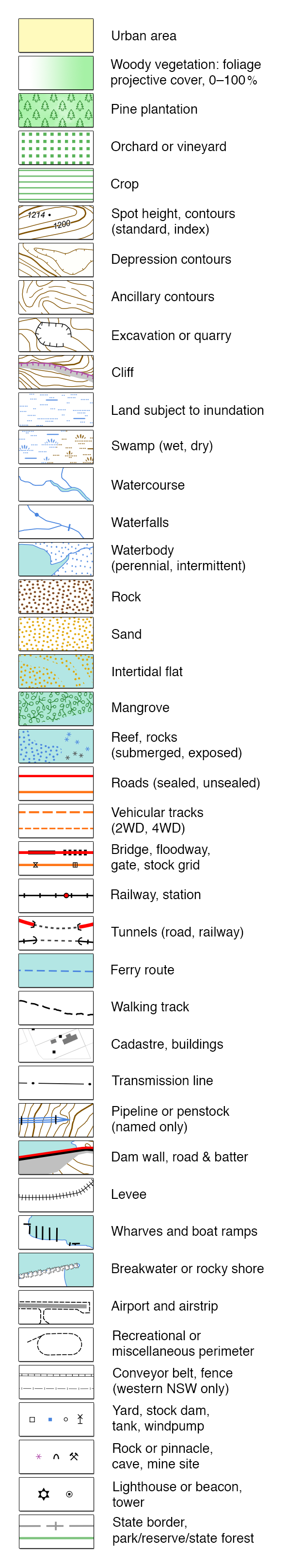
To my way of thinking they are lakes, dry most of the time, not wetlands.
Thoughts? In particular the rendering of the DCS Topo map ... what is
their meaning?
DCS Topo Legend
https://raw.githubusercontent.com/mholling/nswtopo-legends/master/nsw.png
_______________________________________________
Talk-au mailing list
[email protected]
https://lists.openstreetmap.org/listinfo/talk-au