On 22/2/22 18:55, Warin wrote:
On 22/2/22 09:20, Graeme Fitzpatrick wrote:
On Mon, 21 Feb 2022 at 17:30, Warin <[email protected]> wrote:
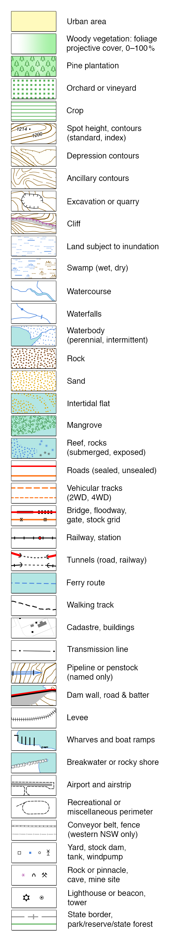
DCS Topo Legend
https://raw.githubusercontent.com/mholling/nswtopo-legends/master/nsw.png
Personally, I think the dry-lake proposal has a lot going for it -
maybe we should just start using it? A comment on it's talk page also
suggested natural=salt_pan, which isn't bad either.
I also notice on the Topo index that they show both wet & dry swamps
- dry swamp may also be an option
Except the Topo map does not map as a wet land/ swamp...
To me a lake would have to have some depth of water in it, not just
soggy soil .. so I against 'lake' if it never has a water surface now,
even though they were lakes in the distant path.
Satellite imagery is not consistent across the 'lake' area .. would
end up being a matrix of surface types.
"A playa is a dry, vegetation-free, flat area at the lowest part of an
undrained desert basin. It is a location where ephemeral lakes form
during wet periods, and is underlain by stratified clay, silt, and
sand, and commonly, soluble salts."
So it is not a playa as defined above by the US Geo Science people...
A 'dry_lake' as defined on the osm wiki "An area of flat, dried-up
land that is almost always dry, but rarely fills with water creating a
very shallow lake."
Humm well it does not define 'rare' so I suppose it is as close as
were are going to get.
As a square peg for a place of round holes :P
natural/landform=dry_lake -3 uses of this in OSM .. so it will not
render.
was:water=lake

name=Lake Mungo
As a matrix of surface types then a multipolugon with each surface
type as a member ...
From http://www.visitmungo.com.au/plants
Looks like the 'lake beds' are mainly shrubs (bluebush and saltbush)
with grasslands on the wetter areas..
Possible ignore grass  and a stretch of things to get


natural=shrub

landform=dry_lake

was:water=lake

name=Mungo Lake


and similar for the rest of these???
I'll have a look tomorrow at the various images to see if I can detect
differences.
_______________________________________________
Talk-au mailing list
[email protected]
https://lists.openstreetmap.org/listinfo/talk-au