It should be added to all buildings then if you want to use it in that way. I
can do that too, but we need some agreement on this. Either we use it or not,
or use it in some particular cases (then we need to decide in which cases).
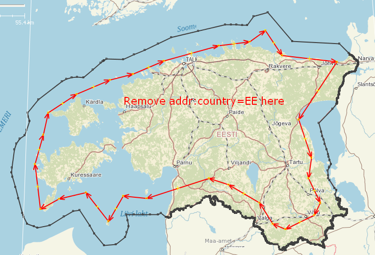
My idea was to use addr:country=EE along the border only (10-20km). That would
help to resolve the ambiguity when people extract countries by a simplified
.poly outline (it's always a simplified one, because the true Estonia border
cosists of 10335 nodes).

Other options would be to either use it everywhere, or to remove it completely.

Leaving things in a chaotic state because people can't decide is probably the
worst option. Any other option would at least have some thoughts behind it and
explanation why it's done in that way.

What's the global practice with this tag? The only thing I've found in wiki is:
"Using addr:country=*, addr:state=*, and addr:province=* are optional, since
they can almost always be determined from boundary relations."

Taginfo doesn't help either:
https://taginfo.openstreetmap.org/keys/addr:country#values
I don't know what to make out of this.

Четверг,  3 октября 2019, 21:56 +03:00 от "Manuel Hohmann"
<[email protected]>:
> I would not remove addr:country=EE, in particular not as a mechanical edit.
> For a human user the country may be obvious, but for software it is much
> simpler to read the tags of an object than to find administrative borders,
> construct their geometry and determine whether a given address is within that
> border or not.
>
> On 03.10.19 21:42, SviMik via Talk-ee wrote:
> > I think I agree with you that the addr:country=EE tag is redundant,
> especially far from the border. Do you think it's okay if I remove this tag
> automatically from all building further than 20km from the border? Like that:
> http://svimik.com/osmaddrcountryremoval1.png
>
>

_______________________________________________
Talk-ee mailing list
[email protected]
https://lists.openstreetmap.org/listinfo/talk-ee