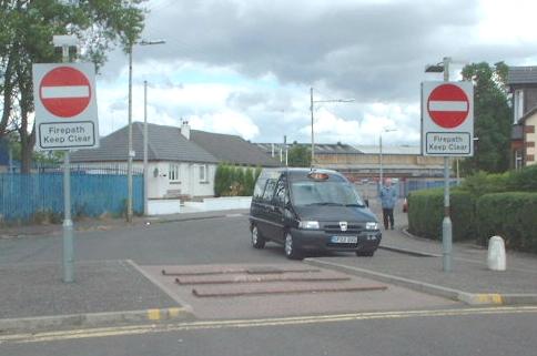
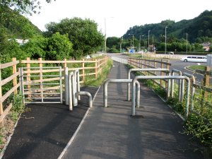
Calum Polwart schrieb:
> On Tue, 2007-12-25 at 10:23 +0100, Frédéric Bonifas wrote:
>
>> This is not a problem for emergency vehicules but for heavy vehicules
>> and the proper tags would be maxweight= or maxwidth=. If this road is
>> tagged with emergency=no, what will we say to the guy cycling this :
>> http://michka.blog50.com/images/medium_italie_pompier_italier_1903.jpg
>> ?!
>>
>> Frédéric
>>
>> 2007/12/25, Alex S. <[EMAIL PROTECTED]>:
>>
>>>> I cannot imagine a situation where I would tag "emergency=no"...
>>>>
> I've been lurking for a while so its time a chipin here's a couple of
> examples:
>
> Some examples of where Emergency=yes might be appropriate (does yes =
> only??):
> Roads at major locations (airports, stadia etc) where 'normal' vehicles
> can not access but emergency vehicles can.  These will often shortcut
> significant distances to an ERV
> (Link to type of signpost in UK:
> http://www.opsi.gov.uk/SI/si2002/023113ew.gif )
>
> Some small streets etc may have a specifically marked route called a
> 'firepath'.  Think of a street like a crescent the firepath is in the
> middle of the crescent separating the two ends.  Its illegal to use the
> firepath normally but fire engines can use it to improve access -->
> (Picture:
> http://www.andypreece.co.uk/cycling/images/barfillan_drive.jpg )(would
> be cycle=no; vehicle=no; emergency=yes) This restriction is kind of
> shown on streetmap.co.uk
> http://www.streetmap.co.uk/newsearch.srf?x=254250&y=664250&z=1&ar=Y&isp=200&ism=500&searchp=newsearch.srf&mapp=newmap.srf&ax=254125&ay=664435
>
>
> But not on
> http://www.multimap.com/maps/?hloc=GB|G52%201BE#t=l&map=55.84928,-4.33172|17|4&loc=GB:55.85098:-4.33172:15|G52%201BE|G52%201BE
>
> While on 'our maps' its shown too well!
> http://www.openstreetmap.org/?lat=55.85022&lon=-4.32831&zoom=16&layers=B0F
> If you are a fire engine coming along Paisley Road West from the West
> (which as it happens is where you'd come from!) you have to go all the
> way to Jura Street to loop back - according to our map... Paisley Road
> West flows at about 2MPH during the day (5MPh if you are a big red
> truck with flashing lights!! so the time may well matter...)
> BUT
exactly for such *highways* we need a "emergency=yes" :)
> Example of  emergency=No:
> there could be similar streets where the path is physically blocked
> because there is an acceptable route for emergency vehicles. (whereas
> this picture
> http://ex-parrot.com/~pete/cycle/difficult-barrier2-thumb.jpg would be
> cycle=yes, vehicle=no, emergency=no)
a node with "highway=bollard" would be all you need here, IMO. But maybe
you find a better one here:
http://wiki.openstreetmap.org/index.php/Proposed_features/barriers.
There is not really a need, for "emergyncy=no", but thre is all the more
for "emergency=yes" or "emergency=designated".

regards,
 mario

_______________________________________________
talk mailing list
[email protected]
http://lists.openstreetmap.org/cgi-bin/mailman/listinfo/talk