Here is a pretty good paper (as far as I can tell) from 2017 looking at ways to
improve single frequency results:
https://www.ncbi.nlm.nih.gov/pmc/articles/PMC5492347/
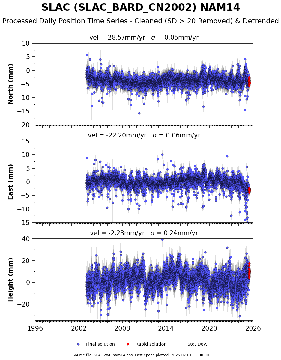
> 28. apr. 2018 kl. 06:20 skrev Jerome Blaha <[email protected]>:
>
> Real-time GPS <0.3m accuracy is quite possible with RTKLIB and < $35 of new
> equipment, some patience, a laptop/android phone, and a real-time RTCM3
> correction station stream (free) or with post-processing using ground
> stations and actual satellite path (Ephemeris).
>
> Disclaimer: I am neither a surveyor nor claimed GPS expert, but I play one on
> TV with my day job, so consult a surveyor if you are having to survey in
> WGS84 datum and convert to NAD or some other reference system, especially if
> testing against old surveyed reference points.  For instance here in the SF
> Bay Area, the land is moving North 28.31mm/yr and West 21.87mm/yr with
> respect to the WGS-84 (GPS Position) datum, which uses satellites orbits and
> the earth center as their reference.   If you were to survey your Telescope
> position in WGS-84 in the Bay Area, wait 15 years and survey again, the
> telescope will appear to have moved Northwest by 53.7cm and will have moved
> down by 1.1cm (Assumptions taken from SLAC de-trended data here:
> https://www.unavco.org/data/gps-gnss/derived-products/position-timeseries/SLAC_timeseries_cleaned_detrended.png)
>
> This is why most surveying is performed not in WGS-84 but in a datum that
> remains fixed to a tectonic plate as it moves, such as NAD83.  The 83 refers
> to the date or year (epoch) when the land position or survey marker was at
> that location, because even surveyed positions can move over time within that
> same tectonic reference frame such as along fault-lines, etc.
>
> Getting back, RTKLIB is a brilliant piece of open-source software to allow
> sub-meter (<5cm) phase-based positioning and my hat goes off to Tomoji Takasu
> from Japan who wrote this and keeps updating it.  Very few GPS receivers can
> measure phase shift, so this is where a specialized L1 + L2 survey receiver
> is needed or you find a cheap L1 GPS chip capable of raw phase and code, such
> as the u-blox M6T or M8T.
>
>
> RECEIVER:
> With regards to a GPS + Glonass raw receiver, the cheapest ublox M8T
> legitimate supplier seems to be over at csgshop.com in Northern Europe.  He
> has the real M8T GPS for $75 and I secretly believe he might also be one of
> the test engineers for u-blox. I say real, because there are knock-offs on
> ebay.
>
> Why did I mention $35?  Well, you can find an M6T gps-only with raw ublox
> output on Amazon and elsewhere called LEA-6T that should get the job done if
> you add a metal ground plane. This little thing works surprisingly well when
> tested for repeatable RTK fixes within 5cm and you can even do a real-time
> RTK fixes with only an Android phone and the older RTK lib App on GooglePlay.
> (M8T not supported)  Don't feel you have to use a newer M8T with GPS +
> Glonass, as usually a GPS-only solution will be superior to a GPS + Gloanss,
> because Glonass seems to have a little more noise to it. (Discussion for
> another time)
>
>
> USGS SURVEY MARKERS
> While we're at it, let's mention that there are survey points all over the
> United States where you can test the accuracy of your newly working RTK GPS
> system.  These are markers placed by the USGS and are typically reported in
> NAD or other American datum format.  These must be converted to WGS-84 datum
> for you to compare with GPS positions and there are tools out there if you do
> a Google search for converting datums to WGS-84, just pay attention to what
> year(epoch) you are converting to and it gets tricky to wrap your head around
> conversion between different Ellipsoids and Geoids (ground height).
> https://www.ngs.noaa.gov/NGSDataExplorer/
>
>
> RTKLIB:
> RTKLIB has multiple tools to allow streaming, real-time, logging,
> post-processing, and graphing RTK GPS fixes.  Typically raw GPS (code & phase
> measurements) are converted to RINEX data format before post-processing.
> RINEX is a standard and allows for raw GPS code and phase measurements
> between different GPS manufactures into one format for processing in
> third-party software.
>
> RTKLIB works in Windows and is a little tough to get started with; thankfully
> there is another very nice guy, Tim Everett, who has written many articles at
> rtkexplorer.com on accuracy of cheap RTK gps chips interfaced with RTKLIB as
> well as tutorials on getting started with pretty pictures.  As a side note,
> you may be tempted to try a newer ublox M8N; however many M8N chips are
> firmware disabled to not give raw phase anymore without firmware hacking.
> (The M8T still works with RTKLIB 2.4.3)
>
>
> SATELLITE PATH (EPHEMERIS)
> When typical GPS receivers are running in real-time, they download an
> approximate ephemeris of where the satellite path flies within a meter or
> two. The final ephemeris is the best true path that the GPS satellite
> actually flew, down to 10cm, however these files are not available until more
> than a week after you collect your raw survey by going to a government
> website such as (https://www.ngs.noaa.gov/orbits/orbit_data.shtml)   These
> post-processed orbital paths are computed from hundred of surveyed ground
> stations around the world to determine the precise track and position that
> each satellite "Bird" actually flew.    It's kind of like a feedback loop for
> oscillator timing correction, by using ground stations to correct an unknown.
>
>
> RTK CORRECTIONS
> For more real-time applications, a surveyed RTK ground station that is nearby
> your location (less than ~15km for L1 only and less than ~100km for an L1 +
> L2 ) can be used.  The farther you are from a reference station, the more
> error you will accumulate in timing errors that cannot account as well for
> clock error, tropospheric, and ionospheric delays.
>
> The real-time reference stations put out RTCM3 corrections which can be used
> in to compute your RTK position in real-time, once ambiguities are solved.
> There is one caveat in that your position is ALWAYS relative to the RTK
> position of the surveyed correction station.  If you put in the wrong
> location of the ground station antenna, your RTK fix will be off by the same
> amount.  A second method is to download the RINEX & RTCM3 files for a station
> and post-process your data in RTKLIB to compute a fix.  It is highly
> recommended to use more than one station to check your position and confirm
> that they correlate within a few cenimeteres for a static point.  Please note
> that a real-time RTK fix with only L1 phase can take 5-30 minutes to achieve
> a lock.  Before locking, they will be floating and may have 1 meter or more
> accuracy.
>
>
> SURVEYED STATIONS
> For a source of free NTRIP surveyed stations for the West Coast, the folks
> over at UNAVCO are again awesome.  If you ask very nicely or are doing
> research, they will give you a free account to their hundreds of RTK
> reference stations.  There are also many other sources of surveyed ground
> stations in you are on the East Coast.
> https://www.unavco.org/data/gps-gnss/real-time/real-time.html  These guys are
> also worth donating to as they are set up all of these reference stations out
> of pocket for free access to everyone as a non-profit university governed
> consortium.
>
>
> BIG TIPS:
> 1)If you plan to run RTKLIB with real-time RTK Static fix to survey a
> stationary point and use the free unavco RTCM3 correction stream, please make
> sure to get the correct station position file for the station you plan to use
> and manually enter the most current computed Lat/Lon/Height into RTKNAVI,
> because if you accidentally click the option to get the station Lat/Lon
> decoded from the RTCM3 stream, your RTK position will have error of the last
> time someone updated the RTCM3 streamed station position.
>
> 2)If you purchase a ublox-M8N or M8T it will not work with the older RTKLIB
> 2.4.2 because they changed the raw stream name, you will need a compiled
> version of the beta 2.4.3 to work.  (There is one on the rtkexplorer site)
>
> 3)Don’t forget a ground plane.  A dinky $5 GPS puck can do surprisingly well
> <5cm repeatable accuracy with a nice circular metal ground plane made of
> perhaps 15cm or more circular metal underneath.  (Just beware of something
> called cycle slip and don't trust the very first RTK fix until it stabilized
> for a while)
>
> If you missed everything above, start with
> http://rtkexplorer.com/how-to/posts-getting-started/ and go from there.
>
> IN MEMORIAM: The GNSS community recently lost a very bright star, Per Eng,
> Ph.D.  He was a GPS Stanford Lab professor, whom worked to improve the GNSS
> standards and safety that are used around the world today.  He will be
> greatly missed and his life work can still be found in online GNSS lectures
> and publications.
>
> -Jerome
> _______________________________________________
> time-nuts mailing list -- [email protected]
> To unsubscribe, go to https://www.febo.com/cgi-bin/mailman/listinfo/time-nuts
> and follow the instructions there.
_______________________________________________
time-nuts mailing list -- [email protected]
To unsubscribe, go to https://www.febo.com/cgi-bin/mailman/listinfo/time-nuts
and follow the instructions there.