My original solution when I changed the living streets back to normal roads
a few months back was to just add extra tags to highlight the features of
the scheme: access, traffic calming, surface, maxspeed:practical etc. I
have just received a message from contributor 'lakedistrict' who raised the
issue back then, supporting the way I tagged the roads.
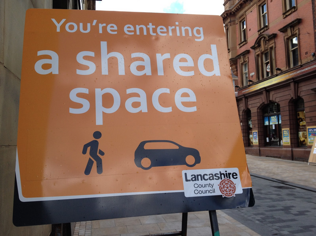
Andy, this scheme does have its own signs
https://designnotes.blog.gov.uk/wp-content/uploads/sites/53/2014/07/Screen-Shot-2014-07-07-at-12.15.04.png
but it doesn't seem to be an official designation in the same way as Home
Zones/Quiet Lanes so maybe if it needs a specific tag, 'designation' isn't
entirely appropriate. Is it better considered a form of traffic calming?
How about traffic_calming=shared_space?

Michael, thanks for the Poynton example. To me that clearly shows why it
shouldn't be a separate category of highway. It looks like two A roads and
a tertiary road cease to exist upon entering the town centre. There is a
tertiary road similarly affected in Preston

Adam


On 1 October 2017 at 16:58, Michael Booth <boot...@gmail.com> wrote:

> One of the first edits I did in OSM was to change my local high street to
> a tertiary road from a living_street. I think I noticed it because it's
> rendered different by osm-carto and some routers wouldn't use the road for
> directions.
>
> It's a 20mph two lane road, except with three traffic calming tables (one
> of which is a pelican crossing), and some larger pavements after
> improvement works reclaimed some parking spaces - so not somewhere like a
> "home zone".
>
> I read about the "shared space" scheme in Poynton, which seemed to be
> about narrowing/redesigning the roads to reduce speeds, and allowing
> pedestrians to cross almost anyway. However I think it's marked wrongly as
> a living_street in OSM: https://www.openstreetmap.org/way/19753268/history
> - funnily enough also by Pete Owens...
>
>
> On 01/10/2017 14:12, Adam Snape wrote:
>
> Hi,
>
> Over the past couple of years Fishergate, the high street in Preston, and
> some surrounding streets have been redeveloped and these highways are now
> designated as 'shared space' https://en.wikipedia.org/wiki/Shared_space
>
> Following redeveleopment these were mapped as "highway=living_street".
> Earlier this year fellow mapper 'lakedistrict' left a note saying that this
> seemed incorrect as this wasn't a residential scheme, I agreed and changed
> the roads to unclassified highways (+ 1 tertiary), adding traffic calming,
> surface and access tags as appropriate. These roads have recently been
> changed back to highway-=living_street by another mapper 'Pete Owens'
> https://www.openstreetmap.org/changeset/52072635
>
> To move things forward I would like others' opinions about how we should
> map such shared space schemes Are we happy to broaden the definition of
> living_street to include them or are they better mapped as ordinary streets
> with additional tags? Another potential option which I toyed with was
> mapping them as highway=pedestrian, adding access tags (bicycles are
> permitted, motor vehicle access varies across the area from 24/7
> thoroughfares, to time conditional/destination/psv only access).
>
> I'll draw lakedistrict and Pete Owens' attentions to this email so that
> they can contribute to the discussion.
>
> Kind regards,
>
> Adam (ACS1986)
>
>
>
>
>
>
>
> _______________________________________________
> Talk-GB mailing
> listTalk-GB@openstreetmap.orghttps://lists.openstreetmap.org/listinfo/talk-gb
>
>
>
> _______________________________________________
> Talk-GB mailing list
> Talk-GB@openstreetmap.org
> https://lists.openstreetmap.org/listinfo/talk-gb
>
>
_______________________________________________
Talk-GB mailing list
Talk-GB@openstreetmap.org
https://lists.openstreetmap.org/listinfo/talk-gb