Kirk,

Great pic!  Glad you still had enough composure to snap a photo!
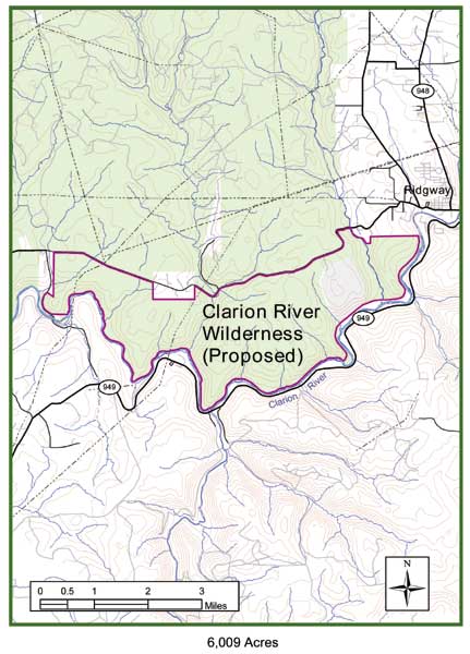
I've met John before at some lumber heritage meetings over the years, but
have spent more time with Bob.  They're both a wealth of information.

I've never walked into Arroyo on the north bank of the river upstream from
the Arroyo Bridge.  I've canoed & kayaked the raceway beside the island a
number of times.  What a blast!

I've put visiting the indian rock overhang site on the north hilltop on my
list of hikes, but haven't got there yet.

Dale

On Tue, Jan 5, 2010 at 4:16 PM, Kirk Johnson <[email protected]> wrote:

> Dale,
>
> Thanks for all of this information, very interesting. I have both of the
> books you reference too. John Imhof took me on a tour of that area in the
> spring of '03, pointing out many of the features of the old mill foundations
> along through the river corridor there. You are right, he is a wealth of
> information. (His brother Bob knows a lot about the area too.)
>
> Mostly we were on the north side of the river. While exploring the old town
> of Arroyo, walking through all the foundations, John points at one in
> particular and suggests I walk up to the top of it and look down in. So I
> did, and right there at the foot of the foundation directly below me was a
> sleeping black bear. He immediately woke up and ran away, pausing at the far
> edge of the foundation to look back (see attached photo). It was pretty
> cool.
>
> If anyone wants to look for large oak trees, there are a lot of them on
> that south-facing slope on the north side of the river between Ridgway and
> Arroyo.
>
> This is also an area of the Allegheny National that Forest Friends of
> Allegheny Wilderness is asking Congress to designate as a wilderness area
> under the Wilderness Act of 1964. See map here:
>
> http://www.pawild.org/images/maps/clarion_river.jpg
>
> To all: letters to Congress in support of this wilderness proposal always
> help! (More info here: http://www.pawild.org )
>
> Thanks again,
>
> Kirk Johnson
>
>
>
>
>
> ENTS,
>
> On 4/21,30/09 I surveyed the Portland Mills Pennsylvania Fish & Boat
> Commission (PAFBC) property on the Clarion River for big trees & historical
> attributes.  The area is part of a proposed land swap between the PAFBC and
> DCNR.  The area is loaded with lumber history and a treasure trove to those
> who love to walk a site and look into its past.  Most signs of human
> disturbance goes unnoticed to the untrained eye, but to those who know what
> to look for, it's one of the best spots on the Clarion River to hunt for old
> mills and tanneries while taking a walk back in time.
>
> Portland Mills is about 34 miles up-river from Cook Forest.  Here's a link
> to various sections of the Clarion River Water Trail map:
>
> http://www.fishandboat.com/watertrails/clarion/clarion-trail.htm
>
> and another link to download the whole guide (~3megs)
> http://www.fishandboat.com/watertrails/clarion/clariontrailguide.pdf
>
> I've had the pleasure of reading several books on lumber history in the
> area.  Two have a great deal of information on the Portland Mills section of
> the Clarion River.  The first is:
>
> Taber, T.  1974.  'Tanbark, Alcohol, and Lumber: The Forest Industries of
> Ridgway, St. Mary's, Hallton, Wilcox, Portland Mills, Straight,
> Johnsonburg'.  by Thomas T. Taber III.
>
> This is book #10 within the series 'Logging Railroad Era of Lumbering in
> Pennsylvania'.  It is a classic to all PA lumber history nuts.
>
> The second is:
>
> Imhof, J.  2003.  'Elk County A Journey Through Time: Volume One The
> Central Clarion Corridor'.  Clarion River Publishing, First Edition, by John
> D. Imhoff.
>
> Both are excellent, but Imhof's book goes into much greater detail.  Here
> are a few excerpts:
>
> "*Early History
> *
> Portland Mills has existed under several different names and in various
> sizes and configurations since the earliest days of recorded local history.
> Early accounts indicate that the area that now encompasses Portland Mills
> was a great gathering point for elk, making it a likely, though unconfirmed
> focus for hunting parties of the native tribes that made their homes to the
> north and west of this vast wilderness.
>
> The earliest recorded pioneers of European descent are said to have been a
> gentleman known as General Wade and his companion, a man known only as
> Slade.  Some tradition holds that Slade was a lieutenant under Wade, but the
> facts are difficult to determine with a high degree of certainty.
>
> Wade had come to the lower Little Toby watershed to remove some of the
> remaining native population, particularly a group near what would later
> become the town of Blue Rock.  During this excursion a brief fight was
> conducted on the slopes above Little Toby Creek, but the natives were
> quickly defeated and relocated.
>
> Wade was apparently fascinated by the area and returned with his family and
> Slade in 1798 to homestead.  The group spent about 5 years in the upper Toby
> valley before moving to the mouth of the stream near what is now called
> Carman.  It was during this period that Slade would encounter a young native
> girl in the Blue Rock area.  Slade would eventually marry the young woman
> who is known to local history as the Indian Maid of the Blue Rock.
>
> Slade and his bride established a trading post somewhere in the
> Carmon-Portland Mills area that would exist for many years.  The year was
> probably 1803, and settlement was officially underway..."
>
> There were a number of different mills and industries located here: 3
> lumber mills, 3 railroads, a tannery, a matchstick factory, lath mill,
> kindling wood plant, hub plant, quarry.  Portland Mills was once a lumber
> boom town that boasted a population of around 1,000 people, now several
> dozen call the town home.  Wish you could see the old photos.  What a change
> from total desolation in the early 1900's to the recovered landscape of
> today.
>
> Eventhough time has wiped away most evidence of past human disturbance, the
> trained eye can still see remants of foundations of a number of houses,
> lumber mill sites, boom piers in the river, train trestle support, and dam
> remnants in the substrate of the river.
>
> The surrounding forest is still recovering.  Sycamore is the most canopy
> dominant tree, and turns out to be the tallest documented so far for the
> Clarion River.  We even found a new staghorn sumac height record for the
> state (paltry few in the database though).  Tree stats follows:
>
> *Species            CBH   Height   Comments
> *
> Am. beech         N/A    80.9
>
> Am. hornbeam   1.4      36.3
>
> black cherry       N/A     91.2
> black cherry       N/A     97.8
> black cherry       7.6     101.8
> black cherry       N/A    106.2
> black cherry       6.1     108.1+
> black cherry       6.2     108.1+
> black cherry       7.8     111.3
>
> butternut            4.5     46.2
>
> dotted hawthorne 2.1    31.9
> dotted hawthorne 3.7    33.3
> dotted hawthorne 2.3    41.7
>
> E. white pine      N/A     116.3
> E. white pine      N/A     121.1       N side of river
>
> Juneberry           N/A     67.5
>
> N. red oak          N/A     104.5
>
> quaking aspen    3.4       79.9
>
> shagbark hickory N/A     69.3
>
> silver maple        9.7      107.3
>
> slippery elm        7.7       66.1+
>
> staghorn sumac  1.7       36.9        tallest documented PA 41 22.920N x 78
> 49.965W
>
> sycamore           N/A      88.1
> sycamore           N/A      99.9
> sycamore           N/A      110.6
> sycamore           10        115.4
> sycamore           N/A      118.4
> sycamore           5.8       118.6
> sycamore          11.4      119.1
> sycamore          N/A       119.7
> sycamore           5.7       123.1
> sycamore           N/A      129.1
> sycamore           4.8       130.6   tallest documented Clarion River 41
> 22.919N x 78 50.007W
>
> tuliptree             N/A       117
>
> white ash           7.3        84.1+
>
>
> The RI for Clarion River-Portland Mills = *100.6
> *
> *Species             CBH     Height
> *
> sycamore           4.8       130.6
> E. white pine      N/A       121.1
> tuliptree             N/A       117
> black cherry       7.8        111.3
> silver maple        9.7        107.3
> N. red oak          N/A       104.5
> white ash           7.3         84.1+
> Am. beech         N/A        80.9
> quaking aspen    3.4         79.9
> shagbark hickory N/A       69.3
>
>
> The addition of the new sycamore record brings up the Clarion River RI to
> 130.97
>
> *Species             CBH     Height   Location
> *
> E. white pine       9.5       149.7     Cook Forest SP
> tuliptree              7.4       141.4     Cook Forest SP
> black cherry        10.2     136.4     Cook Forest SP
> sycamore            4.8      130.6      Portland Mills
> white ash            7.6       128.3     Cook Forest SP
> N. red oak          10.1      126.7     Clear Creek SP
> E. hemlock          9.2      126.7     Cook Forest SP
> pignut hickory      5         126.7     Cook Forest SP
> cucumbertree      7.2       122.6     Cook Forest SP
> Am. beech          9.3       120.6     Cook Forets SP
>
> The tallest trees are mostly found in Cook Forest with all of the Cook
> trees being located in the Cook Trail Old Growth Area (1st bench) or on the
> Foundation Ridge Flat.  Out of 63 recorded sites in PA, the Clarion River
> now rises to 3rd place in PA's Top Ten RI's:
>
> *Site                                          RHI
> *
> Cook Forest State Park              137.38
> Fairmont Park                            132.27
> Clarion River                               130.97
> McConnells Mill State Park         130.85
> Cemetery Run-Meadville, PA       129.23
> Ridley Creek State Park              128.3
> Swarthmore College                    127.55
> Wintergreen Gorge                      127.53
> Ricketts Glen State Park             126.29
> Valley Forge National Park          123.83
>
>
> Dale
>
>
> --
> Eastern Native Tree Society http://www.nativetreesociety.org
> Send email to [email protected]
> Visit this group at http://groups.google.com/group/entstrees?hl=en
> To unsubscribe send email to
> [email protected]<entstrees%[email protected]>
>
>
--
Eastern Native Tree Society http://www.nativetreesociety.org
Send email to [email protected]
Visit this group at http://groups.google.com/group/entstrees?hl=en
To unsubscribe send email to [email protected]