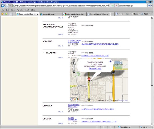
On Apr 30, 9:57 am, TerriLyn <[email protected]> wrote:
> Hello,
>
> I'm trying to get a map to display under the address for a business
> listing when a "Map It" link is clicked (opening a hidden div), and I
> currently have it working properly in IE.  However, it is broken in
> Firefox.  I have images for the problem.  First the working IE model:
>
> http://farm4.static.flickr.com/3335/3488442547_b30cbfbc77.jpg
>
> And then the broken Firefox model.  I have turned on in this image
> some block-level outlining tools, so you can see that despite it being
> all twisted around, there does seem to be a container of sorts being
> drawn with map controls and the Google logo inside it.
>
> http://farm4.static.flickr.com/3299/3488442647_91aca111d7_o.jpg
>
> Unfortunately, I cannot link to a "working site" due to limitations
> here at my work.  However, below is all my map-related javascript, the
> "firing link" and the div tag.
>
> Any suggestions on why this isn't working would be great.
I suspect you are going to have to provide a link. Reasons here: http://groups.google.com/group/Google-Maps-API/web/suggested-posting-guidelines Remove any work related stuff from your example. > > Thanks, > -Terri > > Javascript: > <script type="text/javascript"> > // ksa/sld google map > var mapRow = 0; > function showHideMap(tagId) { > document.getElementById(tagId).style.display='none'; > > } > > </script> > > <script src="http://maps.google.com/maps? > file=api&v=2&key=<bean:write name="dealerLocatorForm" > property="googleKey" filter="false" />" > type="text/javascript"></script> > > <script type="text/javascript"> > > var map = new Array(); > > var geocoder; > if (GBrowserIsCompatible()) > { > geocoder = new GClientGeocoder(); > } > > var directionsPanel; > var directions; > var WINDOW_HTML_TXT; > var gmarkers = []; > var htmls = []; > var to_htmls = []; > var from_htmls = []; > var i=0; > var addrStr; > > function initialize() { > <logic:iterate id="output" name="dealerLocatorForm" > property="dealers" indexId="index"> > <logic:present name="output"> > showHideMap('map_canvas<bean:write name="index"/>') > </logic:present> > </logic:iterate> > } > > function initializeMap() { > <logic:notEqual name="dealerLocatorForm" property="option" > value="default" > > if (GBrowserIsCompatible()) > { > > map[mapRow] = new GMap2(document.getElementById > ("map_canvas"+mapRow)); > > //getting map center from database. > map[mapRow].setCenter(new GLatLng(40.00000,-95.00000), 3); > map[mapRow].addControl(new GSmallMapControl()); > map[mapRow].checkResize(); > geocoder = new GClientGeocoder(); > > } > </logic:notEqual> > > } // initializeMap > > // addAddressToMap() is called when the geocoder returns an > // answer. It adds a marker to the map with an open info window > // showing the nicely formatted version of the address and the > country code. > function addAddressToMap(response, html) { > > var htm=html > map[mapRow].clearOverlays(); > if (!response || response.Status.code != 200) { > // hide previously opened map > document.getElementById > ("map_canvas"+mapRow).style.display='none'; > > if (response && response.Status.code == 500) > alert("Sorry, Google Maps found a server error. > Please call the > dealer for more information."); > else > alert("Sorry, we were unable to map that address.\rPlease > call the dealer for more information."); > } else { > > place = response.Placemark[0]; > point = new GLatLng(place.Point.coordinates[1], > place.Point.coordinates[0]); > > var marker = new GMarker(point); > > GEvent.addListener(marker, "click", function() { > map[mapRow].openInfoWindowHtml(point, WINDOW_HTML_TXT); }); > map[mapRow].setCenter(point, 13); > map[mapRow].addOverlay(marker); > map[mapRow].enableDoubleClickZoom(); > map[mapRow].checkResize(); > map[mapRow].addControl(new GSmallMapControl()); > map[mapRow].openInfoWindowHtml(point, WINDOW_HTML_TXT); > } > } > > // showLocation() is called when you click on the Search button > // in the form. It geocodes the address entered into the form > // and adds a marker to the map at that location. > function showLocation(x, row) { > > var address = x; > // hide previously openedmap > document.getElementById > ("map_canvas"+mapRow).style.display='none'; > > mapRow = row; > initializeMap(); > > geocoder.getLocations(address, addAddressToMap); > > // open curent map > document.getElementById > ("map_canvas"+mapRow).style.display='inline'; > > } > > // populateInfo() is called when you click on the map it link > // it passes the value of infotxt to the global variable of > // WINDOW_HTML_TXT so that it can be displayed on the map. > function populateInfo(srN, srA1, srC , srS, srZ) { > > addrStr = escape(srA1)+",%20"+escape(srC)+",%20"+escape(srS)+", > %20"+escape(srZ); > > WINDOW_HTML_TXT = unescape(srN)+ "<br>"+srA1+"<br>"; > WINDOW_HTML_TXT = WINDOW_HTML_TXT + srC +", "+srS+" "+srZ; > WINDOW_HTML_TXT = WINDOW_HTML_TXT + "<br>"; > WINDOW_HTML_TXT = WINDOW_HTML_TXT + "<a href=http:// > maps.google.com/maps?daddr="+addrStr+" target=_blank class=maplink>Get > Directions</a>"; > > } > > // findLocation() is used to enter the sample addresses into the > form. > function findLocation(address) { > document.forms[0].q.value = address; > showLocation(); > } > </script> > > Body tag: > <body onload="initialize()" onunload="GUnload()"> > > Firing link: > <a href="#" onClick="showLocation('<%=address%> <%=city%>, <%=state%> < > %=zip%>',<bean:write name="index"/>);populateInfo('<%=name%>','< > %=address%>','<%=city%>','<%=state%>','<%=zip%>');return false;" > class="link">Map It</a> > > Table row with div tag: > <tr><td align="center" colspan="2"> </td><td align="center" > colspan="3"><div id="map_canvas<bean:write name="index"/>" > style="width: 400px; height: 300px; z-index:0"></div></td></tr> --~--~---------~--~----~------------~-------~--~----~ You received this message because you are subscribed to the Google Groups "Google Maps API" group. To post to this group, send email to [email protected] To unsubscribe from this group, send email to [email protected] For more options, visit this group at http://groups.google.com/group/Google-Maps-API?hl=en -~----------~----~----~----~------~----~------~--~---